Noceto
| Noceto | |
|---|---|
| Comune | |
| Comune di Noceto | |
|
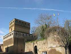
Noceto: the fortress | |
 Noceto Location of Noceto in Italy | |
| Coordinates: 44°49′N 10°11′E / 44.817°N 10.183°ECoordinates: 44°49′N 10°11′E / 44.817°N 10.183°E | |
| Country | Italy |
| Region | Emilia-Romagna |
| Province | Province of Parma (PR) |
| Frazioni | Borghetto, Cella, Costamezzana, Ponte Taro, Sanguinaro |
| Area | |
| • Total | 79.6 km2 (30.7 sq mi) |
| Elevation | 74 m (243 ft) |
| Population (Dec. 2004) | |
| • Total | 11,300 |
| • Density | 140/km2 (370/sq mi) |
| Demonym | Nocetani |
| Time zone | CET (UTC+1) |
| • Summer (DST) | CEST (UTC+2) |
| Postal code | 43015 |
| Dialing code | 0521 |
| Website | Official website |
Noceto (Emiliano-Romagnolo: Nozèi) is a comune (municipality) in the province of Parma in the Italian region Emilia-Romagna, located about 100 kilometres (62 mi) northwest of Bologna and about 12 kilometres (7 mi) west of Parma. As of 31 December 2004, it had a population of 11,300 and an area of 79.6 square kilometres (30.7 sq mi).[1]
The municipality of Noceto contains the frazioni (subdivisions, mainly villages and hamlets) Borghetto, Cella, Costamezzana, Ponte Taro, and Sanguinaro.
Noceto borders the following municipalities: Collecchio, Fidenza, Fontanellato, Fontevivo, Medesano, Parma.
Noceto is a sister city of Walnut Creek in the U.S. state of California.
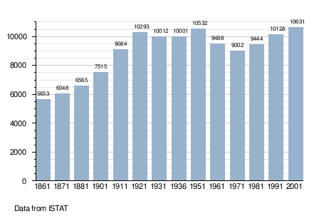
Demographic evolution