Niuoko
| Niuoko islet, Nukulaelae | |
|---|---|
| Atoll | |
|
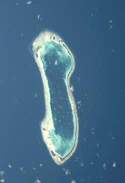
Nukulaelae atoll from space | |
 Niuoko islet, Nukulaelae | |
| Coordinates: 09°22′52″S 179°51′08″E / 9.38111°S 179.85222°ECoordinates: 09°22′52″S 179°51′08″E / 9.38111°S 179.85222°E | |
| Country | Tuvalu |
Main article: Nukulaelae
Niuoko islet is the easternmost point of Tuvalu, which is located in Nukulaelae atoll.[1][2]
The Nukulaelae Conservation Area covers the eastern end of the lagoon. A baseline survey of marine life in the conservation zone was conducted in 2010.[3][4]
In 1865 a trading captain acting on behalf of the German firm of J.C. Godeffroy & Sohn obtained a 25-year lease to Niuoko.[5] For many years the islanders and the Germans argued over the lease, including its terms and the importation of labourers, however the Germans remained until the lease expired in 1890.[5]
References
- ↑ Map of Nukulaelae Atoll. Tuvaluislands.com.
- ↑ British Admiralty Nautical Chart 766 Ellice Islands (1893 ed.). United Kingdom Hydrographic Office (UKHO). 21 March 1872.
- ↑ Sandrine Job, Dr. Daniela Ceccarelli (December 2012). "Tuvalu Marine Life Scientific Report". an Alofa Tuvalu project with the Tuvalu Fisheries Department. Retrieved 3 December 2013.
- ↑ Sandrine Job, Dr. Daniela Ceccarelli (December 2011). "Tuvalu Marine Life Synthesis Report". an Alofa Tuvalu project with the Tuvalu Fisheries Department. Retrieved 3 December 2013.
- ↑ 5.0 5.1 Suamalie N.T. Iosefa, Doug Munro, Niko Besnier (1991). Tala O Niuoku, Te: the German Plantation on Nukulaelae Atoll 1865-1890. Published by the Institute of Pacific Studies. ISBN 9820200733.