Nishi-ku, Hamamatsu
| Nishi-ku 西区 | |
|---|---|
| Ward of Hamamatsu | |
|
Lake Hamana and Hamanako Road Bridge | |
 Location of Nishi-ku in Shizuoka | |
 Nishi-ku
| |
| Coordinates: 34°41′33.77″N 137°38′43.2″E / 34.6927139°N 137.645333°ECoordinates: 34°41′33.77″N 137°38′43.2″E / 34.6927139°N 137.645333°E | |
| Country | Japan |
| Region | Chūbu |
| Prefecture | Shizuoka |
| City | Hamamatsu |
| Area | |
| • Total | 114.40 km2 (44.17 sq mi) |
| Population (July 1, 2012) | |
| • Total | 112,619 |
| • Density | 984/km2 (2,550/sq mi) |
| Time zone | Japan Standard Time (UTC+9) |
| Phone number | 053-597-1111 |
| Address | 1-31-1 Yūtō, Nishi-ku, Hamamatsu, Shizuoka 431-0193 |
| Website | Nishi-ku home page |
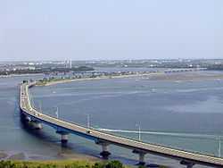
Nishi-ku (西区 Nishi-ku) is one of seven wards of Hamamatsu, Shizuoka, Japan, located in the southwest corner of the city. It is bordered by Naka-ku, Kita-ku, Minami-ku, and the city of Kosai. The 3rd largest ward of Hamamatsu in terms of area, much of the ward is still rural, with farms and rice fields.
Nishi-ku was created on April 1, 2007 when Hamamatsu became a city designated by government ordinance (a "designated city").
Nishi-ku is served by Maisaka Station and Bentenjima Station on the Tōkaidō Main Line railway.
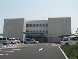
Nishi Ward Office, Hamamatsu
| Wikimedia Commons has media related to Nishi-ku, Hamamatsu. |
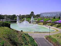
Hamamatsu Flower Park

Kanzanji Hot Springs's buildings
| ||||||||||||||||||||||||||||||||||||||||