Nipe-Sagua-Baracoa
| Nipe-Sagua-Baracoa | |
|---|---|
| Macizo de Nipe Sagua Baracoa | |
|
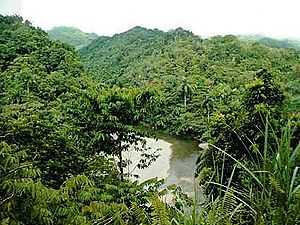
Alejandro de Humboldt National Park, in the middle of the mountain range | |
| Highest point | |
| Peak | Pico Cristal (Sierra Cristal) |
| Elevation | 1,231 m (4,039 ft) |
| Coordinates | 20°32′56.04″N 75°30′16.56″W / 20.5489000°N 75.5046000°W |
| Dimensions | |
| Length | 187 km (116 mi) |
| Width | 50 km (31 mi) |
| Geography | |
|
<div style="padding:2px 2px 5px 2px;>  Location of Nipe-Sagua-Baracoa in Cuba | |
| Country | Cuba |
| Provinces | Holguín and Guantánamo |
| Range coordinates | 20°30′14″N 74°51′00″W / 20.5039°N 74.85°WCoordinates: 20°30′14″N 74°51′00″W / 20.5039°N 74.85°W |
.jpg)
Nipe-Sagua-Baracoa, also knon as Macizo Nipe Sagua Baracoa ("Nipe Sagua Baracoa Massif"), is a mountain range of eastern Cuba located in the provinces of Holguín and Guantánamo.[1][2]
Geography
Overview
Extended for a length of 187 km and a width of 50, the Nipe-Sagua-Baracoa spans from the central-eastern part of the Province of Holguín (near Nipe Bay, Mayarí) to the eastern corner of the one of Guantánamo, up to Maisí. It borders with the mountain range of Sierra Maestra and counts the Pico Cristal that, with an elevation of 1,231 m, is the second Cuban peak after the Pico Turquino (1,974 m).
The range is crossed by the rivers Toa, Mayarí and Sagua de Tánamo.[1]
Composition
The range is composed by several subgroups:[1]
- Sierra del Nipe, with the highest peak at the Loma de la Mensura (994 m)
- Sierra Cristal, with the highest peak at the Pico Cristal (1,231 m)
- Cuchillas de Moa, surrounding the homonym city, with the highest peak at the Pico del Toldo (1,175 m)
- Cuchillas de Baracoa, near the homonym city, with a maximum elevation of 788 m
- Cuchillas del Toa, with the highest peak at the Pico Galán (974 m)
- Sierra del Purial, with a maximum elevation of 1,059 m
- Sierra de Imías, near the homonym town, with the highest peak at the Pico el Gato (1,176 m)
Environment
Nipe-Sagua-Baracoa is known for its biodiversity[2][3][4] and counts the national parks of Sierra Cristal and Alejandro de Humboldt,[5] and the biosphere reserve of Cuchillas del Toa.
See also
References
- ↑ 1.0 1.1 1.2 (Spanish) Nipe-Sagua-Baracoa on EcuRed
- ↑ 2.0 2.1 "Nipe-Sape-Sagua-Baracoa, an example of global biodiversity" (Cuba Headlines)
- ↑ "Nipe-Sagua-Baracoa, an example of global biodiversity" (Conservation International)
- ↑ (Spanish) Article about Nipe-Sagua-Baracoa's biodiversity on lomadelfuerte.wordpress.org
- ↑ Humboldt National Park on the UNESCO website
External links
![]() Media related to Nipe-Sagua-Baracoa at Wikimedia Commons
Media related to Nipe-Sagua-Baracoa at Wikimedia Commons
| ||||||||||