Ninety Mile Beach, Victoria
| Ninety Mile | |
| Beach | |
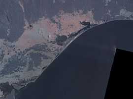 False colour NASA landsat image of Ninety Mile Beach and the Gippsland Lakes | |
| Country | Australia |
|---|---|
| State | Victoria |
| Region | East Gippsland |
| Coordinates | 38°18′8″S 147°17′15″E / 38.30222°S 147.28750°ECoordinates: 38°18′8″S 147°17′15″E / 38.30222°S 147.28750°E |
|
Location of the Ninety Mile Beach in Victoria
| |
The Ninety Mile Beach is a sandy stretch of beach on the south-eastern coastline of the East Gippsland region of Victoria in Australia. The beach faces Bass Strait and backs the Gippsland Lakes. The beach is just over 151 kilometres (94 mi) in length, running north-eastward from a spit near Port Albert to the man-made channel at Lakes Entrance.
Features and location
The Ninety Mile Beach is located about 260 kilometres (160 mi) from Melbourne[1] and can be reached from the South Gippsland Highway passing the coastal towns of McLoughlins Beach, Woodside, Seaspray, Golden Beach, and Loch Sport. The beach is located within the Gippsland Lakes Coastal Park, with the Ninety Mile Beach Marine National Park located off-shore. Behind the beach are long sandy dunes that separate various lakes and lagoons from the ocean. In the northern section, the beach runs along a sandbar on what amounts to a series of tidal islands. Behind this are several large lakes and numerous shallow littoral lagoons. The three main lakes are Lake King, Lake Victoria and Lake Wellington, partially contained within The Lakes National Park.
Ecology
The beach's length ensures that the waves break too close to the beach for good surfing, and there are strong rip currents and cross-currents that make conditions rather hazardous. The local authorities recommend that anyone who wishes to swim should do so at Woodside, Seaspray and Lakes Entrance, which have life saving beach patrols during the summer season.
The beach has golden sand,[2] with crashing waves and a natural bush environment. It is part of the Ninety Mile Beach Marine National Park, which covers 2,750 hectares and 5 kilometres (3.1 mi) of coastline, 30 kilometres (19 mi) south of Sale.[3] There are basic camping facilities within the park at Emu Bight, as well as accommodation at Seaspray and Lakes Entrance.
Rotamah Island, which is part of the Lakes National Park, has a large bird observatory, and can be visited by boat from Paynesville, about 6 kilometres (3.7 mi) away.
The beach is believed to be the fourth longest uninterrupted beach in the world, behind Praia do Cassino on the Brazilian southern coast, Padre Island on the US Gulf Coast and Eighty Mile Beach in Western Australia, which is actually 140 miles (230 km) long.
Wild horses were introduced to the park after the islands were explored to help eat and trample down small areas of bush so it could be more easily explored but they were left unchecked and their numbers quickly increased. Their large numbers grew and over time started to caused concern as environmental damage became an issue, but once the park was established as a national heritage the horses were rounded up and transported back across to the mainland.
Gallery
-
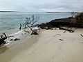
Western edge of Ninety Mile Beach
-
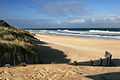
Ninety Mile Beach
-
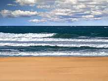
Ninety Mile Beach
References
- ↑ "Ninety Mile Beach, Victoria". web page. Tourism Australia. 2012. Retrieved 15 December 2012.
- ↑ "Gippsland Ninety Mile Beach". web page. Melbourne & Victoria. Retrieved 15 December 2012.
- ↑ "Ninety Mile Beach Marine National Park". web page. Parks, Victoria. 2012. Retrieved 15 December 2012.