Nilwande Dam
| Nilwande Dam | |
|---|---|
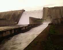 Nilwande Dam in 2011 | |
 | |
| Official name | Upper Pravara Nilwande Dam D02986 |
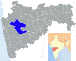
| Location | Akole, Akole taluka, India |
| Coordinates | 19°32′46″N 73°54′05″E / 19.54611°N 73.90139°ECoordinates: 19°32′46″N 73°54′05″E / 19.54611°N 73.90139°E |
| Construction began | 1999 |
| Opening date | 2011 |
| Demolition date | N/A |
| Owner(s) | Government of Maharashtra, India |
| Operator(s) | Command Area Development Authority (CADA), Ahmednagar |
| Dam and spillways | |
| Type of dam | RCC |
| Impounds | Pravara river |
| Height | 73.91 m (242.5 ft) |
| Length | 583 m (1,913 ft) |
| Reservoir | |
| Creates | Nilwande Dam |
| Catchment area | 202 km2 (78 sq mi) |
Nilwande dam, also called as Upper Pravara dam, in the Indian state of Maharashtra is the second largest dam on the Pravara river. The dam is located near Akole, Ahmednagar district.[1]
Specifications
The height of the dam above lowest foundation is 73.91 m (242.5 ft) while the length is 583 m (1,913 ft).
Purpose
- Irrigation
See also
- Dams in Maharashtra
- List of reservoirs and dams in India
References
- ↑ "Upper Pravara D02986". Retrieved March 19, 2013.
| ||||||||||||||||||||||||||||||||||||||||