Nikopol, Dnipropetrovsk Oblast
- For Nikopol in Bulgaria see Nikopol, Bulgaria.
| Nikopol Нікополь | |||
|---|---|---|---|
| City of regional significance | |||
|
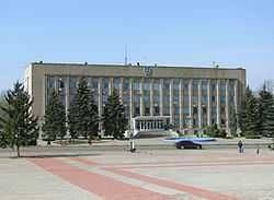
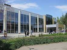
City Administration Building. | |||
| |||
 Nikopol Nikopol in Ukraine | |||
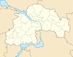 Nikopol Nikopol in Dnipropetrovsk Oblast | |||
| Coordinates: 47°34′N 34°24′E / 47.567°N 34.400°ECoordinates: 47°34′N 34°24′E / 47.567°N 34.400°E | |||
| Country |
| ||
| Oblast |
| ||
| City Municipality |
| ||
| Founded | 1782 | ||
| Area | |||
| • Total | 50 km2 (20 sq mi) | ||
| Population (2013) | |||
| • Total | 118 720 | ||
| • Density | 2,764/km2 (7,160/sq mi) | ||
| Postal code | 53200—53239 | ||
| Area code(s) | +380-5662 | ||
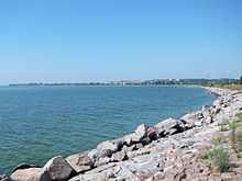
Nikopol (Ukrainian: Ні́кополь; Russian: Ни́кополь; Greek: Νικόπολις, literally: "City of Victory") is a city in Ukraine, in the Dnipropetrovsk Oblast, on the right bank of the Dnieper River, about 100 km south-west of Dnipropetrovsk. Administratively, Nikopol is incorporated as the city of oblast significance and serves as the administrative center of Nikopol Raion which it does not belong to. Population: 118,720 (2013 est.)[1].
In terms of population, Nikopol is the third biggest city in the oblast as well as among the top 50 nationwide. The city is also a powerful industrial and transportation center in the country conveniently located by the Kakhovka reservoir.
Encyclopædia Britannica description
The 1911 edition of Encyclopædia Britannica gave the following description of Nikopol: It was formerly called "Mykytyn Rog", and occupies an elongated peninsula between two arms of the Dnieper at a point where its banks are low and marshy, and has been for centuries one of the places where the middle Dnieper can most conveniently be crossed.
In 1900, its 21,282 inhabitants were Ukrainians, Jews and Mennonites, who carry on agriculture and shipbuilding. The old Sich, or fortified camp of the Zaporozhian Cossacks, brilliantly described in N. V. Gogol's novel Taras Bulba (1834), was situated a little higher up the river. Numbers of graves in the vicinity recall the battles which were fought for the possession of this important strategic point. One of them, close to the town, contained, along with other Scythian antiquities, the well-known precious vase representing the capture of wild horses. Even now Nikopol, which is situated on the highway from Dnipropetrovsk to Kherson, is the point where the "salt-highway" of the Chumaks (Ukrainian salt-carriers) to the Crimea crosses the Dnieper. Nikopol is, further, one of the chief places on the lower Dnieper for the export of corn, linseed, hemp and wool.
History
There are some claims by the Russian and Polish historians referring to the area in the medieval and late-medieval times as the Wild Fields. That, of course, is a dubious identification as the land here is famous for its fruitfulness, being cultivated since the remotest past. The land for a long time was ruled by both the Polish-Lithuanian Commonwealth and Moscovy which wanted to colonize it.
In times of the Kievan Rus the land belonged to the Pechenegs, who later were displaced by the Polovtsi (also known as Cumans) that established their own state in today's southern Ukraine and Crimea. In the 13th century the advancing Mongol hordes had conquered the Polovtsi, only running into difficulties in the Crimea, and established the Golden Horde state. After the fall of the Golden Horde, it is believed that the land belonged to the Nogai people (later under the suzerainty of the Crimean Khanate), although it is possible that the land might have been inhabited by a Slavic population as well. Whatever the case, the first concrete historical evidence found for a Slavic settlement is from the 15th century, when the area was being populated by the Cossacks. This was first documented in the diary of E.Liasota.
By 1648, in the close proximity of today's Nikopol, Mykytyn Sich was built, renowned for the fact that it was here that Bohdan Khmelnytsky was elected as the Hetman of Ukraine, and it was here that war against the Catholic Polish state has started. Until 1775, the time of the Sich sacking, it was called "Mykytyn Rih", "Mykytyn Pereviz", or simply "Mykytyne". The name rih (Ukrainian for horn) was given because the locality rose at a place reminiscing a peninsula, as it was almost surrounded by the Dnieper river (see Kryvyi Rih). Mykytyne was a town of the Kodak Palanka, an administrative division of the Zaporizhian Sich. Later it was renamed into Slovianske and then Nikopol.
Interestingly, what could be now the most sacred place of an early distinctly Ukrainian statehood was eventually submerged by water, owing to the Soviet policy of industrialization. The Kakhovka Reservoir covers now the lands of the former Zaporizhian Host and the burial sites of thousands of former heroes whose names, probably, will never be recovered.
During World War II, Nikopol was occupied by the German Army from August 17, 1941 to February 8, 1944.
Just a few miles west of the city was buried the Kosh otaman Ivan Sirko.
International relations
Twin towns — Sister cities
Nikopol is twinned with:
External links
References
- ↑ "Чисельність наявного населення України (Actual population of Ukraine)" (in Ukrainian). State Statistics Service of Ukraine. Retrieved 21 January 2015.
- ↑ "Lista municipiilor înfrățite din România" [List of municipality twinnings in Romania] (in Romanian). Archived from the original on 2009-12-22. Retrieved 2013-08-21.
 This article incorporates text from a publication now in the public domain: Chisholm, Hugh, ed. (1911). Encyclopædia Britannica (11th ed.). Cambridge University Press.
| ||||||||||||||||||||||||||||