Nienhagen, Mecklenburg-Vorpommern
| Nienhagen | ||
|---|---|---|
| ||
 Nienhagen | ||
Location of Nienhagen within Rostock district  | ||
| Coordinates: 54°10′N 11°58′E / 54.167°N 11.967°ECoordinates: 54°10′N 11°58′E / 54.167°N 11.967°E | ||
| Country | Germany | |
| State | Mecklenburg-Vorpommern | |
| District | Rostock | |
| Municipal assoc. | Bad Doberan-Land | |
| Government | ||
| • Mayor | Uwe Kahl | |
| Area | ||
| • Total | 5.90 km2 (2.28 sq mi) | |
| Population (2013-12-31)[1] | ||
| • Total | 1,881 | |
| • Density | 320/km2 (830/sq mi) | |
| Time zone | CET/CEST (UTC+1/+2) | |
| Postal codes | 18211 | |
| Dialling codes | 038203 | |
| Vehicle registration | LRO | |
| Website | www.doberan-land.de | |

Nienhagen is a municipality in the Rostock district, in Mecklenburg-Vorpommern, Germany.
Geography
The municipality lies on the Baltic Sea Coast between the oldest German seaside spa of Heiligendamm and Warnemünde.
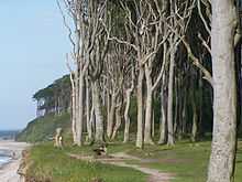
Large parts of the municipal territory are forested. West of the village lies Nienhagen Wood (Nienhäger Holz) immediately behind the roughly 12 metre high sea cliffs. This mixed forest is circa 180 hectares in area and is called Ghost Wood (Gespensterwald) by the locals. The origin of this description is not exactly known, but is probably derived from its 1.25 kilometre long and around 100 metre wide coastal strip of the wood, which is mainly stocked with beech and a few oaks. The beech trees, in particular, have been shaped by the sea winds, grow mainly on one side and have twisted, snake-like branches, which gives them a ghostly appearance especially at twilight and in the mist.

A footpath with picturesque views runs immediately behind the sea cliffs to Börgerende. Below the cliffs are beaches of fine sand, suitable for bathing, interesting piles of scree and several large glacial erratics. A mile off the coast in the Baltic Sea is Nienhagen Artificial Reef which is used for research.
External links
 Media related to Nienhagen at Wikimedia Commons
References
- ↑ "Bevölkerungsstand der Kreise, Ämter und Gemeinden in Mecklenburg-Vorpommern 31.12.2013". Statistisches Amt Mecklenburg-Vorpommern (in German). 23 September 2014.