Niederhorn
Not to be confused with Niderhorn.
| Niederhorn | |
|---|---|
|
View from the Güggisgrat (north-east side) | |
| Elevation | 1,963 m (6,440 ft) |
| Prominence | 45 m (148 ft)[1] |
| Isolation | 1.2 km (0.75 mi)[2] |
| Parent peak | Burgfeldstand |
| Location | |
 Niederhorn Location in Switzerland | |
| Location | Bernese Oberland, Switzerland |
| Range | Emmental Alps |
| Coordinates | 46°42′39″N 7°46′24″E / 46.71083°N 7.77333°ECoordinates: 46°42′39″N 7°46′24″E / 46.71083°N 7.77333°E |

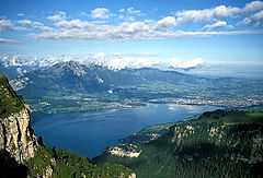
The Niederhorn (elevation 1963 metres) is a peak of the Emmental Alps in the Bernese Oberland near Beatenberg. It is the peak farthest west in the Güggis ridge. From its summit you can see Lake Thun and the entire Bernese Alps.
An aerial cable car to the summit was completed in 1946 with a restaurant and children's playground at the top. Today the summit can be reached by the Seilbahnen Beatenberg-Niederhorn, a more modern gondola lift that runs from the village of Beatenberg, where it connects with the Thunersee–Beatenberg Bahn, a funicular with connections to the shipping services on Lake Thun.[3]
See also
References
- ↑ Retrieved from the Swisstopo topographic maps. The key col is located east of the summit at 1,918 metres.
- ↑ Retrieved from Google Earth. The nearest point of higher elevation is southwest of the Burgfeldstand.
- ↑ Richard Green (2007). Railways in the Berner Oberland - Part 3. Today's Railways Europe: Issue 134: February 2007. Platform 5 Publishing Ltd.
External links
- Neiderhorn web site (in German)
- Niederhorn on Hikr