Niderviller
| Niderviller | |
|---|---|
 Niderviller | |
|
Location within Lorraine region  Niderviller | |
| Coordinates: 48°42′49″N 7°06′31″E / 48.7136°N 7.1086°ECoordinates: 48°42′49″N 7°06′31″E / 48.7136°N 7.1086°E | |
| Country | France |
| Region | Lorraine |
| Department | Moselle |
| Arrondissement | Arrondissement of Sarrebourg |
| Canton | Canton of Sarrebourg |
| Intercommunality | Communauté de communes de la Vallée de la Bièvre |
| Government | |
| • Mayor (2008–2014) | Claude Vouriot |
| Area1 | 10.75 km2 (4.15 sq mi) |
| Population (1999)2 | 1,069 |
| • Density | 99/km2 (260/sq mi) |
| INSEE/Postal code | 57505 / 57565 |
| Elevation |
257–364 m (843–1,194 ft) (avg. 300 m or 980 ft) |
|
1 French Land Register data, which excludes lakes, ponds, glaciers > 1 km² (0.386 sq mi or 247 acres) and river estuaries. 2 Population without double counting: residents of multiple communes (e.g., students and military personnel) only counted once. | |
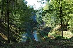
The Marne-Rhine Canal at Niderviller, Moselle.
Niderviller is a commune in the Moselle department in Lorraine in north-eastern France. It is mostly known for the Niderviller pottery, established in 1735 and still producing there.