Ngatimoti
| Ngatimoti | |
|---|---|
|
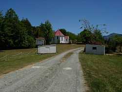
St. James' Anglican Church, November, 2007 | |
 Ngatimoti Ngatimoti's location within New Zealand | |
| Coordinates: 41°13′S 172°54′E / 41.217°S 172.900°ECoordinates: 41°13′S 172°54′E / 41.217°S 172.900°E | |
| Country |
|
| Time zone | NZST (UTC+12) |
| • Summer (DST) | NZDT (UTC+13) |
| Area code | 03 |
Ngatimoti is a town near Motueka in New Zealand's South Island. Its Māori name means "of Timothy".
The town lies on the banks of the Motueka River and has been inhabited since 1855 when the Salisbury brothers arrived in the river valley. The local economy includes forestry, apple orchards and sheep and dairy farming.
History
The name for this community came from a recently converted Māori Christian who carved his name into a tree at the corner of what is now Ngatimoti school. On 1 January 1860 the town featured the first gathering of the Brethren religious movement, at the house of a local man, James George Deck and by the 1900 census the movement had nearly 2% of the total NZ population. This created a tension between Brethren and Anglican settlers in the valley. The Anglicans sent troops to World War I, while the Brethren adopted a semi-pacifist stance. The first New Zealander to die in the conflict was from Ngatimoti. An ongoing characteristic of the community is the peaceful coexistence and respect a wide variety of lifestyles and viewpoints, including conservative farmers, hippies and communes. The town experienced major floods in 1877 and 1990, contributed to by extensive deforestation of the steep surrounding region.
School
Ngatimoti School is a small school that was opened on August 17, 1868.[1]
St. James Church
St. James is an Anglican church which was erected in 1884. The building is constructed of Tōtara and Rimu.[2]
External links
- Ngatimoti Tasman District Council website
- Ngatimoti War Memorial
- Ngatimoti School
- Ngatimoti Hall
- St James Church, painting and brief history from Don Donovan's blog.
- Church gets historic bell back Article from the Nelson Mail, 24/12/2010
- Ngatimoti's Peninsula Bridge Celebrates 100 Years Sarah J Ryder, News from Nelson/Tasman, NZ