Newton, New Jersey
| Newton, New Jersey | |
|---|---|
| Town | |
| Town of Newton | |
|
Spring Street seen from the Newton Town Green | |
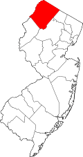
 Map of Newton in Sussex County. Inset: Location of Sussex County highlighted in the State of New Jersey. | |
 Census Bureau map of Newton, New Jersey | |
| Coordinates: 41°03′10″N 74°45′17″W / 41.052742°N 74.754787°WCoordinates: 41°03′10″N 74°45′17″W / 41.052742°N 74.754787°W[1][2] | |
| Country |
|
| State |
|
| County | Sussex |
| Incorporated | April 11, 1864 |
| Government[3] | |
| • Type | Faulkner Act (Council-Manager) |
| • Mayor | E. Kevin Elvidge (term ends June 30, 2016)[4][5] |
| • Manager | Thomas S. Russo, Jr.[6] |
| • Clerk | Lorraine A. Read[7] |
| Area[1] | |
| • Total | 3.169 sq mi (8.207 km2) |
| • Land | 3.146 sq mi (8.147 km2) |
| • Water | 0.023 sq mi (0.060 km2) 0.73% |
| Area rank |
327th of 566 in state 18th of 24 in county[1] |
| Elevation[8] | 663 ft (202 m) |
| Population (2010 Census)[9][10][11] | |
| • Total | 7,997 |
| • Estimate (2013)[12] | 7,942 |
| • Rank |
288th of 566 in state 7th of 24 in county[13] |
| • Density | 2,542.2/sq mi (981.5/km2) |
| • Density rank |
245th of 566 in state 3rd of 24 in county[13] |
| Time zone | Eastern (EST) (UTC-5) |
| • Summer (DST) | Eastern (EDT) (UTC-4) |
| ZIP code | 07860[14][15] |
| Area code(s) | 973 exchanges: 300, 383, 579, 940[16] |
| FIPS code | 3403751930[1][17][18] |
| GNIS feature ID | 0885322[1][19] |
| Website |
www |

Newton, officially the Town of Newton, is an incorporated municipality located in Sussex County, New Jersey, United States. It is one of fifteen municipalities in the state organized as a town, and the municipal government operates under a council-manager structure provided by the Faulkner Act, or Optional Municipal Charter Law. As the location of the county's administrative offices and court system, Newton is the county seat of Sussex County.[20][21]
Newton was incorporated by an act of the New Jersey Legislature on April 11, 1864, from portions of Newton Township, which was also partitioned to create Andover Township and Hampton Township, and was then dissolved. Additional land was acquired from Andover Township in 1869 and 1927, and from Fredon Township in 1920.[22]
As of the 2010 United States Census, the town's population was 7,997,[9][10][11] reflecting a decline of 247 (-3.0%) from the 8,244 counted in the 2000 Census, which had in turn increased by 723 (+9.6%) from the 7,521 counted in the 1990 Census.[23]
Geography
Geology
Newton is located in the Kittatinny Valley, part of the Great Appalachian Valley and is located in the Ridge and Valley Appalachians physiographic province. This physiographic province occupies approximately two-thirds of the county's area (the county's western and central sections) dominated by Kittatinny Mountain and the Kittatinny Valley. This province's contour is characterized by long, even ridges with long, continuous valleys in between that generally run parallel from southwest to northeast. The features of the Ridge and Valley province were created approximately 300–400 million years ago during the Ordovician period and Appalachian orogeny—a period of tremendous pressure and rock thrusting that caused the creation of the Appalachian Mountains.[24][25] This region is largely formed by sedimentary rock.[26][27]
Political geography
According to the United States Census Bureau, the town had a total area of 3.169 square miles (8.207 km2), of which, 3.146 square miles (8.147 km2) of it was land and 0.023 square miles (0.060 km2) of it (0.73%) was water.[1][2]
Climate and weather
Because of its location in the higher elevations of northwestern New Jersey's Appalachian mountains, Newton, as well as the rest of Sussex County, has a cooler humid continental climate or microthermal climate (Köppen climate classification Dfb) which indicates patterns of significant precipitation in all seasons and at least four months where the average temperature rises above 10 °C (50 °F)[28][29][30] This differs from the rest of the state which is generally a humid mesothermal climate, in which temperatures range between -3 °C (27 °F) and 18 °C (64 °F) during the year's coldest month.[29][31] Sussex County is part of USDA Plant Hardiness Zone 6.[32][33]
During winter and early spring, New Jersey in some years is subject to "nor'easters"—significant storm systems that have proven capable of causing blizzards or flooding throughout the northeastern United States. Hurricanes and tropical storms, tornadoes, and earthquakes are relatively rare. The Kittatinny Valley to the north of Newton, part of the Great Appalachian Valley, experiences a snowbelt phenomenon and has been categorized as a microclimate region known as the "Sussex County Snow Belt." This region receives approximately forty to fifty inches of snow per year and generally more snowfall that the rest of Northern New Jersey and the Northern Climate Zone.[34] This phenomenon is attributed to the orographic lift of the Kittatinny Ridge which impacts local weather patterns by increasing humidity and precipitation.[35]
In recent years, average temperatures in the county seat of Newton have ranged from a low of 17 °F (−8 °C) in January to a high of 84 °F (29 °C) in July. Average monthly precipitation ranged from 2.86 inches (73 mm) in February to 4.76 inches (121 mm) in June.[36]
According to the USDA Natural Resource Conservation Service soil survey, the area receives sunshine approximately 62% of the time in summer and 48% in winter. Prevailing winds are typically from the southwest for most of year; but in late winter and early spring come from the northwest. The lowest recorded temperature was −26 °F on January 21, 1994. The highest recorded temperature was 104 °F (40 °C) on September 3, 1953. The heaviest one-day snowfall was 24 inches recorded on January 8, 1996 (combined with the next day, total snowfall was 40 inches). The heaviest one-day rainfall—6.70 inches— was recorded on August 19, 1955.[37]
Demographics
| Historical population | |||
|---|---|---|---|
| Census | Pop. | %± | |
| 1870 | 2,403 | — | |
| 1880 | 2,513 | 4.6% | |
| 1890 | 3,003 | 19.5% | |
| 1900 | 4,376 | 45.7% | |
| 1910 | 4,467 | 2.1% | |
| 1920 | 4,125 | −7.7% | |
| 1930 | 5,401 | 30.9% | |
| 1940 | 5,533 | 2.4% | |
| 1950 | 5,781 | 4.5% | |
| 1960 | 6,563 | 13.5% | |
| 1970 | 7,297 | 11.2% | |
| 1980 | 7,748 | 6.2% | |
| 1990 | 7,521 | −2.9% | |
| 2000 | 8,244 | 9.6% | |
| 2010 | 7,997 | −3.0% | |
| Est. 2013 | 7,942 | [12][38] | −0.7% |
| Population sources: 1870-1920[39] 1870[40][41] 1880-1890[42] 1890-1910[43] 1910-1930[44] 1930-1990[45] 2000[46][47] 2010[9][10][11] | |||

Census 2010
At the 2010 United States Census, there were 7,997 people, 3,170 households, and 1,842 families residing in the town. The population density was 2,542.2 per square mile (981.5/km2). There were 3,479 housing units at an average density of 1,106.0 per square mile (427.0/km2). The racial makeup of the town was 85.04% (6,801) White, 4.88% (390) Black or African American, 0.49% (39) Native American, 2.98% (238) Asian, 0.05% (4) Pacific Islander, 4.34% (347) from other races, and 2.23% (178) from two or more races. Hispanics or Latinos of any race were 12.34% (987) of the population.[9]
There were 3,170 households, of which 27.2% had children under the age of 18 living with them, 40.1% were married couples living together, 13.7% had a female householder with no husband present, and 41.9% were non-families. 36.1% of all households were made up of individuals, and 16.8% had someone living alone who was 65 years of age or older. The average household size was 2.34 and the average family size was 3.06.[9]
In the town, 21.2% of the population were under the age of 18, 8.7% from 18 to 24, 24.7% from 25 to 44, 26.8% from 45 to 64, and 18.5% who were 65 years of age or older. The median age was 41.9 years. For every 100 females there were 91.5 males. For every 100 females age 18 and over, there were 87.6 males.[9]
The Census Bureau's 2006-2010 American Community Survey showed that (in 2010 inflation-adjusted dollars) median household income was $48,702 (with a margin of error of +/- $7,922) and the median family income was $72,266 (+/- $10,712). Males had a median income of $57,369 (+/- $5,859) versus $29,676 (+/- $3,910) for females. The per capita income for the borough was $25,296 (+/- $2,141). About 10.9% of families and 12.8% of the population were below the poverty line, including 21.2% of those under age 18 and 16.6% of those age 65 or over.[48]
Census 2000
As of the 2000 United States Census[17] there were 8,244 people, 3,258 households, and 1,941 families residing in the town. The population density was 2,661.7 people per square mile. There were 3,425 housing units at an average density of 1,105.8 per square mile. The racial makeup of the town was 91.97% White, 2.80% African American, 0.13% Native American, 1.97% Asian, 0.01% Pacific Islander, 1.16% from other races, and 1.35% from two or more races. Hispanic or Latino of any race were 3.80% of the population.[46][46][47]
There were 3,258 households out of which 30.1% had children under the age of 18 living with them, 44.0% were married couples living together, 11.5% had a female householder with no husband present, and 40.4% were non-families. 33.5% of all households were made up of individuals and 14.5% had someone living alone who was 65 years of age or older. The average household size was 2.39 and the average family size was 3.12.[46][47]
In the town, the population was spread out with 23.9% under the age of 18, 7.6% from 18 to 24, 31.2% from 25 to 44, 21.6% from 45 to 64, and 15.6% who were 65 years of age or older. The median age was 38 years. For every 100 females there were 92 males. For every 100 females age 18 and over, there were 90.5 males.[46][47]
The median income for a household in the town was $44,667, and the median income for a family was $56,484. Males had a median income of $41,089 versus $30,016 for females. The per capita income for the town was $20,577. About 6.9% of families and 11.2% of the population were below the poverty line, including 11.4% of those under age 18 and 11% of those age 65 or over.[46][47]
Government
Local government

Newton operates within the Faulkner Act, formally known as the Optional Municipal Charter Law, under the Council-Manager form of municipal government (Plan B), implemented based on the recommendations of a Charter Study Commission as of July 1, 1978.[49] The town is governed by a five-member Town Council, whose members are chosen at-large in nonpartisan elections to four-year terms of office on a staggered basis, with either two or three seats coming up for election in May of even years in alternating fashion. The council selects a mayor and deputy mayor from among its members at a reorganization meeting held after each election.[3]
As of 2015, members of the Town Council are Mayor E. Kevin Elvidge (term on committee ends June 30, 2018; term as mayor ends 2016), Deputy Mayor Daniel G. Flynn (term on committee and as deputy mayor ends 2016), Kristen S. Becker (2016), Sandra Lee Diglio (2018) and Wayne F. Levante (2018).[4][50][51][52]
Law enforcement and public safety
Newton has a municipal police department. Newton is also home to the Sussex County Sheriff's Office. A barracks for the New Jersey State Police is located in Augusta, New Jersey several miles north of Newton.
Federal, state and county representation

Newton is located in the 5th Congressional District[53] and is part of New Jersey's 24th state legislative district.[10][54][55]
New Jersey's Fifth Congressional District is represented by Scott Garrett (R, Wantage Township).[56] New Jersey is represented in the United States Senate by Cory Booker (D, Newark, term ends 2021)[57] and Bob Menendez (D, Paramus, 2019).[58][59]
For the 2014-2015 Session, the 24th Legislative District of the New Jersey Legislature is represented in the State Senate by Steve Oroho (R, Franklin) and in the General Assembly by Alison Littell McHose (R, Franklin) and Parker Space (R, Wantage Township).[60][61] The Governor of New Jersey is Chris Christie (R, Mendham Township).[62] The Lieutenant Governor of New Jersey is Kim Guadagno (R, Monmouth Beach).[63]
Sussex County is governed by a Board of Chosen Freeholders whose five members are elected at-large in partisan elections on a staggered basis, with either one or two seats coming up for election each year. At an annual reorganization meeting held in the beginning of January, the board selects a Freeholder Director and Deputy Director from among its members, with day-to-day supervision of the operation of the county delegated to a County Administrator.[64] As of 2014, Sussex County's Freeholders are Freeholder Director Richard Vohden (R, Green Township, 2016),[65] Deputy Director Dennis J. Mudrick (R, Sparta Township, 2015),[66] Phillip R. Crabb (R, Franklin, 2014),[67] George Graham (R, Stanhope, 2016)[68] and Gail Phoebus (R, Andover Township, 2015).[69][64] Graham was chosen in April 2013 to fill the seat vacated by Parker Space, who had been chosen to fill a vacancy in the New Jersey General Assembly.[70] Constitutional officers elected on a countywide basis are County Clerk Jeff Parrott (R, 2016),[71] Sheriff Michael F. Strada (R, 2016)[72] and Surrogate Gary R. Chiusano (R, filling the vacancy after the resignation of Nancy Fitzgibbons).[73][70] The County Administrator is John Eskilson.[74][75]
Politics
As of March 23, 2011, there were a total of 4,476 registered voters in Newton, of which 881 (19.7% vs. 16.5% countywide) were registered as Democrats, 1,537 (34.3% vs. 39.3%) were registered as Republicans and 2,052 (45.8% vs. 44.1%) were registered as Unaffiliated. There were 6 voters registered to other parties.[76] Among the town's 2010 Census population, 56.0% (vs. 65.8% in Sussex County) were registered to vote, including 71.0% of those ages 18 and over (vs. 86.5% countywide).[76][77]
In the 2012 presidential election, Republican Mitt Romney received 1,546 votes (50.9% vs. 59.4% countywide), ahead of Democrat Barack Obama with 1,395 votes (45.9% vs. 38.2%) and other candidates with 87 votes (2.9% vs. 2.1%), among the 3,038 ballots cast by the town's 4,645 registered voters, for a turnout of 65.4% (vs. 68.3% in Sussex County).[78] In the 2008 presidential election, Republican John McCain received 1,747 votes (54.8% vs. 59.2% countywide), ahead of Democrat Barack Obama with 1,359 votes (42.6% vs. 38.7%) and other candidates with 62 votes (1.9% vs. 1.5%), among the 3,189 ballots cast by the town's 4,418 registered voters, for a turnout of 72.2% (vs. 76.9% in Sussex County).[79] In the 2004 presidential election, Republican George W. Bush received 1,903 votes (59.6% vs. 63.9% countywide), ahead of Democrat John Kerry with 1,220 votes (38.2% vs. 34.4%) and other candidates with 54 votes (1.7% vs. 1.3%), among the 3,191 ballots cast by the town's 4,359 registered voters, for a turnout of 73.2% (vs. 77.7% in the whole county).[80]
In the 2013 gubernatorial election, Republican Chris Christie received 67.3% of the vote (1,210 cast), ahead of Democrat Barbara Buono with 29.5% (531 votes), and other candidates with 3.2% (58 votes), among the 1,808 ballots cast by the town's 4,705 registered voters (9 ballots were spoiled), for a turnout of 38.4%.[81][82] In the 2009 gubernatorial election, Republican Chris Christie received 1,161 votes (57.0% vs. 63.3% countywide), ahead of Democrat Jon Corzine with 620 votes (30.4% vs. 25.7%), Independent Chris Daggett with 203 votes (10.0% vs. 9.1%) and other candidates with 34 votes (1.7% vs. 1.3%), among the 2,037 ballots cast by the town's 4,323 registered voters, yielding a 47.1% turnout (vs. 52.3% in the county).[83]
Education
Elementary and secondary schools
The Newton Public School District serves students in Kindergarten through twelfth grade. As of the 2011-12 school year, the district's three schools had an enrollment of 1,532 students and 127.0 classroom teachers (on an FTE basis), for a student–teacher ratio of 12.06:1.[84] Schools in the district (with 2010-11 enrollment data from the National Center for Education Statistics[85]) are Merriam Avenue School[86] (499 students; grades K-5), Halsted Street Middle School[87] (238; 6-8) and Newton High School[88] (800; 9-12).[89][90] The district's enrollment includes high school students from Andover Borough, Andover Township and Green Township, who attend the high school as part of sending/receiving relationships with their respective home districts.[91]
Founded in 1956, the Saint Joseph's Regional School is a private school affiliated with parish of Newton's Saint Joseph's Roman Catholic Church and overseen by the Roman Catholic Diocese of Paterson.[92][93][94] St Joseph's provides classes from pre-Kindergarten (ages 3-5) to seventh-grade for a total enrollment of 140 students.[92]
|


Higher education

Sussex County Community College (commonly referred to as SCCC) is a accredited, co-educational, two-year, public, community college located on a 167-acre (68 ha) campus in Newton. The SCCC campus was formerly the site of Don Bosco College, a Roman Catholic seminary operated by the Salesian Order from 1928 until it was closed in the early 1980s and its campus sold to the Sussex County government on 22 June 1989 for US$4,209,800.[95][96]
SCCC was authorized as a "college commission" in 1981 and began operations the following year. It became fully accredited in 1993 by the Commission on Higher Education of the Middle States Association of Colleges and Schools.[97][98] SCCC offers 40 associate degree and 16 post-secondary professional and health science certificate programs available both at traditional classes at its campus, through hybrid and online classes, and through distance learning.[98][99][100] Many students who attend SCCC transfer to pursue the completion of their undergraduate college education at a four-year college or university.[99][101] The college also offers programs for advanced high school students, community education courses, and programs in cooperation with the New Jersey Department of Labor and Workforce Development.[102] As of 2012, SCCC reported an enrollment of 3,403 students of which 56% attend full-time and 44% attended part-time.[97]
Infrastructure
Roads and highways
Newton is located at the intersection of U.S. Route 206 (known within Newton as Woodside Avenue, Main Street, and Water Street), New Jersey Route 94 (known within Newton as High Street and Water Street), and County Route 519 (known within Newton as West End Avenue and Mill Street) and County Route 616 (known within Newton as Spring Street and Sparta Avenue).[103] As of May 2010, the town had a total of 28.75 miles (46.27 km) of roadways, of which 21.18 miles (34.09 km) were maintained by the municipality, 4.47 miles (7.19 km) by Sussex County and 3.10 miles (4.99 km) by the New Jersey Department of Transportation.[104] Interstate 80 is accessible approximately 13 miles (21 km) to the south.
Public transportation

The nearest New Jersey Transit rail station is Netcong, approximately 12 miles (19 km) to the south.
Lakeland Bus Lines provides limited service between Newton and the Port Authority Bus Terminal in Midtown Manhattan.[105]
Local bus service is provided by the Skylands Connect bus, which connects to Sparta, Hamburg, and Sussex.[106]
Aviation
Newton Airport is a public-use airport located 3 miles (4.8 km) south of the central business district.[107]
Health care
Newton Memorial Hospital opened in the early 1930s, during the Great Depression. The medical center was established thanks to a willed gift of $35,000 from Thomas Murray (to be specifically used to establish a hospital in Newton) and a $100,000 bequest from Clarence Linn. According to their website, "Newton Memorial Hospital is a short-term, fully accredited, 146-bed acute care, not-for-profit hospital serving more than 250,000 people in Warren and Sussex counties in New Jersey, Pike County in Pennsylvania and southern Orange County in New York."[108]
Media
Newspapers
Newton is home to the editorial offices of The New Jersey Herald, the state's oldest newspaper, founded in 1829.
Radio and television
The town of Newton has two radio stations within its borders, WNNJ, on 103.7 FM, with a format of Rock, and WTOC (AM) also serves Newton in Spanish at 1360 AM.
WMBC-TV is licensed to Newton, but its studios are in West Caldwell, NJ and its transmitter is near Lake Hopatcong.
Notable people
People who were born in, residents of, or otherwise closely associated with Newton include:
- Thomas Oakley Anderson (1783–1844), American naval officer, involved in the raiding party, led by Stephen Decatur on February 16, 1804, to destroy the U.S. frigate Philadelphia which ran aground in Tripoli harbor during the First Barbary War.[109]
- Danny Baugher (born 1984), punter who has played in the NFL for the Oakland Raiders.[110]
- Susanna Bokoyni (1879-1984), circus performer and oldest living little person on record.[111]
- Will Bradley (1912–1989), trombonist.[112]
- Johnny Budd (1899–1963), football player in the early NFL for the Frankford Yellow Jackets and the Pottsville Maroons.[113]
- Henry J. B. Cummings (1831–1909), member of the United States Congress who represented Iowa's 7th congressional district.[114]
- Newman E. Drake (1860-1930), founder of Drake's bakery.[115]
- Janeane Garofalo (born 1964), actress and comedian.[116]
- John W. Griggs (1849–1927), 27th Governor of New Jersey who later served as United States Attorney General.[117]
- Robert Hamilton (1809–1878), represented New Jersey's 4th congressional district in the United States House of Representatives from 1873-1877.[118]
- Ardolph L. Kline (1858–1930), represented Brooklyn in the United States House of Representatives from Brooklyn in 1921–23 and served in 1913 as acting Mayor of New York City.[119]
- Leonard LaRue (1914–2001), captain of the SS Meredith Victory who was involved in the largest humanitarian rescue operation by a single ship in human history[120]
- Mary Tuthill Lindheim (1912-2004), sculptor.[121]
- Robert H. McCarter (1859–1948), New Jersey Attorney General from 1903-09.[122]
- Rodman M. Price (1816–1894), represented New Jersey's 5th congressional district in the United States House of Representatives from 1851–1853, and served as the 17th Governor of New Jersey, from 1854 to 1857.[123]
- Andrew J. Rogers (1828–1900), represented New Jersey's 4th congressional district in the United States House of Representatives from 1863-1867.[124]
- Red Strader (1902–1956), football player and coach.[125]
- Matt Valenti (born 1984), two-time national champion wrestler for the University of Pennsylvania who won the 133 pound weight class at the NCAA tournament in both 2006 and 2007.[126]
Points of interest
- Christ Church, founded 1770 (episcopal)
- First Presbyterian Church of Newton
- Memory Park, donated by Newman E. Drake
- Newton Abbey, also known as St Paul's Abbey, a Benedictine monastery.
- Newton Cemetery[127]
- Newton Theatre
- Old Newton Burial Ground
- Sussex County Courthouse
- Newton Town Green
- Spring Street
- Sussex County Community College
- Horton Mansion on the SCCC campus[128]
References
- ↑ 1.0 1.1 1.2 1.3 1.4 1.5 Gazetteer of New Jersey Places, United States Census Bureau. Accessed June 14, 2013.
- ↑ 2.0 2.1 US Gazetteer files: 2010, 2000, and 1990, United States Census Bureau. Accessed September 4, 2014.
- ↑ 3.0 3.1 2012 New Jersey Legislative District Data Book, Rutgers University Edward J. Bloustein School of Planning and Public Policy, March 2013, p. 110.
- ↑ 4.0 4.1 Town Council, Town of Newton. Accessed February 7, 2015.
- ↑ 2014 New Jersey Mayors Directory, New Jersey Department of Community Affairs, as of December 15, 2014. Accessed April 7, 2015. As of date accessed, Joseph Ricciardo was listed as mayor with a term-end year of 2015.
- ↑ Town Manager, Town of Newton. Accessed June 28, 2012.
- ↑ Municipal Clerk, Town of Newton. Accessed June 28, 2012.
- ↑ U.S. Geological Survey Geographic Names Information System: Town of Newton, Geographic Names Information System. Accessed March 8, 2013.
- ↑ 9.0 9.1 9.2 9.3 9.4 9.5 DP-1 - Profile of General Population and Housing Characteristics: 2010 for Newton town, Sussex County, New Jersey, United States Census Bureau. Accessed February 24, 2013.
- ↑ 10.0 10.1 10.2 10.3 Municipalities Grouped by 2011-2020 Legislative Districts, New Jersey Department of State, p. 11. Accessed January 6, 2013.
- ↑ 11.0 11.1 11.2 Profile of General Demographic Characteristics: 2010 for Newton town, New Jersey Department of Labor and Workforce Development. Accessed February 24, 2013.
- ↑ 12.0 12.1 PEPANNRES - Annual Estimates of the Resident Population: April 1, 2010 to July 1, 2013 - 2013 Population Estimates for New Jersey municipalities, United States Census Bureau. Accessed June 16, 2014.
- ↑ 13.0 13.1 GCT-PH1 Population, Housing Units, Area, and Density: 2010 - State -- County Subdivision from the 2010 Census Summary File 1 for New Jersey, United States Census Bureau. Accessed February 24, 2013.
- ↑ Look Up a ZIP Code for Newton, NJ, United States Postal Service. Accessed February 24, 2013.
- ↑ Zip Codes, State of New Jersey. Accessed October 25, 2013.
- ↑ Area Code Lookup - NPA NXX for Newton, NJ, Area-Codes.com. Accessed October 25, 2013.
- ↑ 17.0 17.1 American FactFinder, United States Census Bureau. Accessed September 4, 2014.
- ↑ A Cure for the Common Codes: New Jersey, Missouri Census Data Center. Accessed June 28, 2012.
- ↑ US Board on Geographic Names, United States Geological Survey. Accessed September 4, 2014.
- ↑ Find a County], National Association of Counties. Accessed April 7, 2015.
- ↑ Sussex County, NJ, National Association of Counties. Accessed January 21, 2013.
- ↑ Snyder, John P. The Story of New Jersey's Civil Boundaries: 1606-1968, Bureau of Geology and Topography; Trenton, New Jersey; 1969. p. 231. Accessed June 28, 2012.
- ↑ Table 7. Population for the Counties and Municipalities in New Jersey: 1990, 2000 and 2010, New Jersey Department of Labor and Workforce Development, February 2011. Accessed February 24, 2013.
- ↑ Hatcher, Robert D., Jr. "Tracking lower-to-mid-to-upper crustal deformation processes through time and space through three Paleozoic orogenies in the Southern Appalachians using dated metamorphic assemblages and faults" in Abstracts with Programs (Geological Society of America), Vol. 40, No. 6, 513. Accessed August 28, 2012.
- ↑ Bartholomew, M.J., and Whitaker, A.E., 2010, The Alleghanian deformational sequence at the foreland junction of the Central and Southern Appalachians in Tollo, R.P., Bartholomew, M.J., Hibbard, J.P., and Karabinos, P.M., eds., From Rodinia to Pangea: The Lithotectonic Record of the Appalachian Region, GSA Memoir 206, p. 431-454.
- ↑ Lucey, Carol S. Geology of Sussex County in Brief. (Trenton, NJ: New Jersey Geological Survey, November 1969), 21pp. Accessed August 28, 2012.
- ↑ Dalton, Richard. New Jersey Geological Survey Information Circular: Physiographic Provinces of New Jersey (Trenton, NJ: Department of Environmental Protection, State of New Jersey, 2003, 2006). Accessed August 28, 2012.
- ↑ The determination of Dfb (warm summer subtype) region is from Peel, M. C., Finlayson, B. L., and McMahon, T. A. (University of Melbourne). Updated world map of the Köppen-Geiger climate classification from Hydrology and Earth System Sciences (2007), 11:1633–1644, doi:10.5194/hess-11-1633-2007. Accessed August 3, 2011.
- ↑ 29.0 29.1 Thornthwaite, Charles Warren. Atlas of Climatic Types in the United States 1900-1939: U.S. Department of Agriculture Miscellaneous Publication 421. (Washington, DC: U.S. Department of Agriculture, 1941); and Thornthwaite. "The Climates of North America: According to a New Classification" in Geographical Review (October 1931), 21(4):633-655.
- ↑ Climate Summary for Newton, New Jersey
- ↑ See also: Hare, F.K. "Climatic classification" in Stamp, L.D., and Wooldridge, S.W. (editors). The London Essays in Geography (Cambridge, Massachusetts: Harvard University Press, 1951), 111-134.
- ↑ "What is my arborday.org Hardiness Zone?", Arbor Day Foundation. Accessed March 31, 2013.
- ↑ 2012 USDA Plant Hardiness Zone Map (USA), United States Department of Agriculture, Agricultural Research Service and Oregon State University. (2012). Accessed August 3, 2013.
- ↑ Office of the New Jersey State Climatologist
- ↑ Carney, Leo. H. "Weather; Microclimates, Big Variations.", The New York Times, January 30, 2005. Accessed September 21, 2014. "In places like Hidden Valley and throughout the snow belt of northwestern Sussex County, a condition known as orographic lifting can increase humidity and precipitation."
- ↑ Monthly Averages for Newton, New Jersey, The Weather Channel. Accessed October 13, 2013.
- ↑ U.S. Department of Agriculture Natural Resource Conservation Service, Soil Survey of Sussex County, New Jersey (Washington, DC: 2009).
- ↑ Census Estimates for New Jersey April 1, 2010 to July 1, 2013, United States Census Bureau. Accessed September 23, 2014.
- ↑ Compendium of censuses 1726-1905: together with the tabulated returns of 1905, New Jersey Department of State, 1906. Accessed October 24, 2013.
- ↑ Raum, John O. The History of New Jersey: From Its Earliest Settlement to the Present Time, Volume 1, p. 271, J. E. Potter and company, 1877. Accessed February 24, 2013. "Newton contains the town of Newton, the seat of justice of the county. It contained in 1850, 3,279 inhabitants; in 1860, including the village 4,098; and in 1870 2,403."
- ↑ Staff. A compendium of the ninth census, 1870, p. 260. United States Census Bureau, 1872. Accessed February 20, 2013.
- ↑ Porter, Robert Percival. Preliminary Results as Contained in the Eleventh Census Bulletins: Volume III - 51 to 75, p. 99. United States Census Bureau, 1890. Accessed October 24, 2013.
- ↑ Thirteenth Census of the United States, 1910: Population by Counties and Minor Civil Divisions, 1910, 1900, 1890, United States Census Bureau, p. 338. Accessed June 28, 2012.
- ↑ Fifteenth Census of the United States: 1930 - Population Volume I, United States Census Bureau, p. 719. Accessed February 24, 2013.
- ↑ New Jersey Resident Population by Municipality: 1930 - 1990, Workforce New Jersey Public Information Network, backed up by the Internet Archive as of May 2, 2009. Accessed February 24, 2013.
- ↑ 46.0 46.1 46.2 46.3 46.4 46.5 Census 2000 Profiles of Demographic / Social / Economic / Housing Characteristics for Newton town, New Jersey, United States Census Bureau. Accessed June 28, 2012.
- ↑ 47.0 47.1 47.2 47.3 47.4 DP-1: Profile of General Demographic Characteristics: 2000 - Census 2000 Summary File 1 (SF 1) 100-Percent Data for Newton town, Sussex County, New Jersey, United States Census Bureau. Accessed February 24, 2013.
- ↑ DP03: Selected Economic Characteristics from the 2006-2010 American Community Survey 5-Year Estimates for Newton town, Sussex County, New Jersey, United States Census Bureau. Accessed June 28, 2012.
- ↑ "The Faulkner Act: New Jersey's Optional Municipal Charter Law", New Jersey State League of Municipalities, July 2007. Accessed October 25, 2013.
- ↑ 2014 Municipal Data Sheet, Town of Newton. Accessed September 18, 2014.
- ↑ pages/docs/2012/Newton-5-8-2012-results.html Newton Municipal Election - May 8, 2012 - Unofficial Results, Sussex County, New Jersey Clerk, run date May 8, 2012. Accessed February 24, 2013.
- ↑ pages/docs/2014/20140513-EL45-OFFICIAL.html SUMMARY REPORT SUSSEX COUNTY, NEW JERSEY OFFICIAL RESULTS NEWTON MUNICIPAL ELECTION MAY 13, 2014, Sussex County Clerk, run date May 14, 2014. Accessed September 18, 2014.
- ↑ Plan Components Report, New Jersey Redistricting Commission, December 23, 2011. Accessed January 6, 2013.
- ↑ 2012 New Jersey Citizen's Guide to Government, p. 62, New Jersey League of Women Voters. Accessed January 6, 2013.
- ↑ Districts by Number for 2011-2020, New Jersey Legislature. Accessed January 6, 2013.
- ↑ Directory of Representatives: New Jersey, United States House of Representatives. Accessed January 5, 2012.
- ↑ About Cory Booker, United States Senate. Accessed January 26, 2015. "He now owns a home and lives in Newark's Central Ward community."
- ↑ Biography of Bob Menendez, United States Senate, January 26, 2015. "He currently lives in Paramus and has two children, Alicia and Robert."
- ↑ Senators of the 114th Congress from New Jersey. United States Senate. Accessed January 26, 2015. "Booker, Cory A. - (D - NJ) Class II; Menendez, Robert - (D - NJ) Class I"
- ↑ Legislative Roster 2014-2015 Session, New Jersey Legislature. Accessed February 11, 2014.
- ↑ District 24 Legislators, New Jersey Legislature. Accessed February 11, 2014.
- ↑ "About the Governor". State of New Jersey. Retrieved 2010-01-21.
- ↑ "About the Lieutenant Governor". State of New Jersey. Retrieved 2010-01-21.
- ↑ 64.0 64.1 Sussex County Board of Chosen Freeholders, Sussex County, New Jersey. Accessed July 28, 2014.
- ↑ Richard A. Vohden, Sussex County, New Jersey. Accessed July 28, 2014.
- ↑ Dennis J. Mudrick, Sussex County, New Jersey. Accessed July 28, 2014.
- ↑ Phillip R. Crabb, Sussex County, New Jersey. Accessed July 28, 2014.
- ↑ George Graham, Sussex County, New Jersey. Accessed July 28, 2014.
- ↑ Gail Phoebus, Sussex County, New Jersey. Accessed July 28, 2014.
- ↑ 70.0 70.1 Miller, Jennifer Jean. "George Graham Chosen as Freeholder at Sussex County Republican Convention", TheAlternativePress.com, April 13, 2013. Accessed April 25, 2013. "Graham will fill the freeholder seat that New Jersey Assemblyman Parker Space left to take his new position. Space recently took the seat, which formerly belonged to Gary Chiusano, who in turn, was appointed to the spot of Sussex County Surrogate, following the retirement of Surrogate Nancy Fitzgibbons."
- ↑ Home Page, Sussex County Clerk's Office. Accessed July 28, 2014.
- ↑ Sheriff's Office, Sussex County, New Jersey. Accessed July 28, 2014.
- ↑ Home Page, Sussex County Surrogate. Accessed July 28, 2014.
- ↑ County Administrator, Sussex County, New Jersey. Accessed July 28, 2014.
- ↑ Sussex County Official Directory 2014, Sussex County, New Jersey. Accessed July 28, 2014.
- ↑ 76.0 76.1 Voter Registration Summary - Sussex, New Jersey Department of State Division of Elections, March 23, 2011. Accessed February 24, 2013.
- ↑ GCT-P7: Selected Age Groups: 2010 - State -- County Subdivision; 2010 Census Summary File 1 for New Jersey, United States Census Bureau. Accessed February 24, 2013.
- ↑ General Election November 6, 2012: District Report - Group Detail, Sussex County, New Jersey Clerk, run date November 30, 2012. Accessed February 26, 2013.
- ↑ 2008 Presidential General Election Results: Sussex County, New Jersey Department of State Division of Elections, December 23, 2008. Accessed February 24, 2013.
- ↑ 2004 Presidential Election: Sussex County, New Jersey Department of State Division of Elections, December 13, 2004. Accessed February 24, 2013.
- ↑ "Governor - Sussex County" (PDF). New Jersey Department of Elections. January 29, 2014. Retrieved December 24, 2014.
- ↑ "Number of Registered Voters and Ballots Cast - November 5, 2013 - General Election Results - Sussex County" (PDF). New Jersey Department of Elections. January 29, 2014. Retrieved December 24, 2014.
- ↑ 2009 Governor: Sussex County, New Jersey Department of State Division of Elections, December 31, 2009. Accessed February 24, 2013.
- ↑ District information for Newton School District, National Center for Education Statistics. Accessed September 18, 2014.
- ↑ School Data for the Newton Public School District, National Center for Education Statistics. Accessed September 18, 2014.
- ↑ Merriam Avenue School, Newton Public School District. Accessed October 25, 2013.
- ↑ Halsted Street Middle School, Newton Public School District. Accessed October 25, 2013.
- ↑ Newton High School, Newton Public School District. Accessed October 25, 2013.
- ↑ Schools, Newton Public School District. Accessed October 25, 2013.
- ↑ New Jersey School Directory for the Newton Public School District, New Jersey Department of Education. Accessed October 24, 2013.
- ↑ Newton High School 2013 Report Card Narrative, New Jersey Department of Education. Accessed April 7, 2015. "Newton High School serves students from Andover Township, Andover Borough, and Green Township as well as historic Newton."
- ↑ 92.0 92.1 About Us: 2014–2015 School Profile, St Joseph's Regional School, Newton, New Jersey. Retrieved 15 April 2015.
- ↑ About Us: Affiliated Parish, St Joseph's Regional School. Retrieved 15 April 2015.
- ↑ About Us: Accreditation, St Joseph's Regional School, Newton, New Jersey. Retrieved 15 April 2015.
- ↑ Sussex County Clerk's Office (Newton, New Jersey), Register of Deeds. Deed between the Salesian Society, Inc., a corporation of the State of New York being the parent company of Don Bosco College and the Salesian Society of New Jersey, Inc., and The County of Sussex, a political division of the State of New Jersey (May 10, 1989, filed June 22, 1989) in Deed Book 1662, page 022 et seq. (Instrument No. 89-39284).
- ↑ Wright, Kevin. Newton NJ: Pearl of the Kittatinny – "The Horton Mansion Former Don Bosco Campus, now Sussex County Community College". Note: Wright states it was 1984 but I suspect this is either a typographical error or an intentional copyright trap. Accessed July 10, 2012.
- ↑ 97.0 97.1 Sussex County Community College (Newton, NJ). "Our History". Accessed 10 July 2012.
- ↑ 98.0 98.1 Middle States Commission on Higher Education, Middle States Association of Colleges and Schools.Institution Directory: Sussex County Community College. Accessed July 18, 2012.
- ↑ 99.0 99.1 Sussex County Community College (Newton, NJ). "Degrees, Programs and Certificates". Accessed August 2, 2013.
- ↑ Sussex County Community College (Newton, NJ). "Distance Learning". Accessed August 2, 2013.
- ↑ Sussex County Community College (Newton, NJ). "The Degree Advantage: Complete your Associate Degree at SCCC and give yourself the edge when you transfer". Accessed August 2, 2013.
- ↑ Sussex County Community College Community Education and Workforce Development. Accessed August 2, 2013.
- ↑ Route 94 Straight Line Diagram, New Jersey Department of Transportation. Accessed October 25, 2013.
- ↑ Sussex County Mileage by Municipality and Jurisdiction, New Jersey Department of Transportation, May 2010. Accessed July 18, 2014.
- ↑ LAKELAND RT 80 NEWTON TO PABT, Lakeland Bus Lines. Accessed September 18, 2014.
- ↑ Skylands Connect, Sussex County, New Jersey. Accessed September 18, 2014.
- ↑ Newton Airport, New Jersey Department of Transportation. Accessed February 24, 2013.
- ↑ Newton Memorial Hospital
- ↑ Lee, Francis Bazley. Genealogical and Memorial History of the State of New Jersey, p. 1550. Lewis Historical Publishing Company, 1910. Accessed October 25, 2013. "Thomas Oakley Anderson, son of Thomas and Letitia Anderson, was born in Newton, Sussex county, New Jersey, in 1793, and died there in 1844. In his minority he entered the United States navy, and as an ensign at the age of eighteen years, he took part in the daring attempt of Commodore Decatur to rescue the frigate Philadelphia from the Tripolitans who had captured it."
- ↑ Danny Baugher, Fox Sports (USA). Accessed February 5, 2011.
- ↑ Weird NJ Your Travel Guide to New Jerseys Local Legends and Best Kept Secrets. Barnes and Noble. 2004. p. 120. ISBN 0-7607-3979-X.
- ↑ Yanow, Scott. Swing, p. 22. Hal Leonard Corporation, 2000. ISBN 0-87930-600-9. Accessed February 5, 2011.
- ↑ Johnny Budd, Pro-Football-Reference.com. Accessed February 5, 2011.
- ↑ Henry Johnson Brodhead Cummings, Biographical Directory of the United States Congress. Accessed February 5, 2011.
- ↑ Staff. "NEWMAN E. DRAKE DIES AFTER OPERATION; Founder of Bakery Concern Bearing Family Name--Spent Youth on Farm.", The New York Times, March 20, 1930. Accessed February 5, 2011. "Funeral services will be held at 3:15 PM on Saturday at his late home, 27 Inwood Avenue, Newton, N.J."
- ↑ Longsdorf, Amy. "SPOTLIGHT ON JANEANE GAROFALO ROMANTIC COMEDY STAR STILL DOESN'T FEEL LIKE `THE PRETTY GIRL'", The Morning Call, October 4, 1997. Accessed February 5, 2011. "Born in Newton, NJ, Garofalo's taste in comedy has always run to neurotic funnymen such as Woody Allen and Albert Brooks."
- ↑ New Jersey Governor John William Griggs, National Governors Association. Accessed February 5, 2011.
- ↑ Robert Hamilton, Biographical Directory of the United States Congress. Accessed September 3, 2007.
- ↑ Staff. "EX-MAYOR KLINE DIES AT AGE OF 72; City's Chief Executive a Few Months Upon Death of Mayor Gaynor in 1913. ONCE HEAD OF ALDERMEN A Brigadier General in the National Guard--Was With U.S. Shipping Board at His Death. Joined National Guard in 1876. Praised by Gaynor.", The New York Times, October 14, 1930. Accessed October 25, 2013.
- ↑ Goldstein, Richard. "Leonard LaRue, Rescuer in the Korean War, Dies at 87", The New York Times, October 20, 2001. Accessed June 28, 2012. "Brother Marinus Leonard LaRue, who as a merchant marine captain in the Korean War evacuated 14,000 refugees from a besieged North Korean port, died on Sunday at St. Paul's Abbey in Newton, N.J.... In 1954, he left the sea to join the Benedictines at St. Paul's Abbey, where he lived until his death."
- ↑ Staff. "Book details Sausalito artist's life", Twin Cities Times, November 24, 2010. Accessed October 25, 2013. "Born in Newton, N.J., and raised in Tucson, Ariz., Tuthill arrived in California in 1928."
- ↑ Robert H. McCarter: Attorney General 1903-1908, New Jersey Department of Law & Public Safety. Accessed February 5, 2011.
- ↑ Rodman McCamley Price, Biographical Directory of the United States Congress. Accessed September 24, 2007.
- ↑ Andrew Jackson Rogers, Biographical Directory of the United States Congress. Accessed September 2, 2007.
- ↑ Staff. "STRADER IS NAMED COACH OF BULLDOGS", The New York Times, January 6, 1950. Accessed June 28, 2012. "He was born at Newton, N. J., on Dec. 21, 1904."
- ↑ Staff. "Matt Valenti Added to Columbia Wrestling Coaching Staff", Columbia University, August 17, 2007. Accessed February 5, 2011. "A three-time All-Ivy League first team selection, the native of Newton, N.J. earned the Fletcher Award for most team points in a career at EIWA's."
- ↑ Newton Cemetery Company. Newton Cemetery: About Us (cemetery website). Accessed February 24, 2013.
- ↑ The Horton Mansion, Newton, NJ. Accessed February 24, 2013.
Reading list
- Gordon, Kate; McCabe, Wayne T. (1998). Newton (Images of America). Charleston, SC: Arcadia Publishing.
- McCabe, Wayne T.; Gordon, Kate (1996). A Penny A View...An Album of Postcard Views...Newton, N.J. Newton, New Jersey: Historic Preservation Alternatives.
- Wright, Kevin W. (1999). Around The Green, Newton, New Jersey. Newton, N.J.: Minisink Press.
External links
- Newton Town website
- History of Newton, NJ, includes historical views & comprehensive description
- Newton Fire Museum
- Newton Public School District
- Newton Police Department
- Newton Fire Department
- Newton First Aid Squad
- Newton Memorial Hospital
- Newton Public School District's 2012–13 School Report Card from the New Jersey Department of Education
- The Township Journal, community newspaper
- Newton Public School District, National Center for Education Statistics
| |||||||||||||||||||||||||||||