Newhaven, Edinburgh


Newhaven is a district in the City of Edinburgh, Scotland, between Leith and Granton and about 2 miles (3.2 km) north of the city centre. Formerly a village and harbour on the Firth of Forth, it had a population of approximately 5,000 inhabitants at the 1991 census. Newhaven was designated a conservation area, one of 40 such areas in Edinburgh, in 1977.[1]
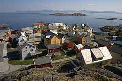
It has a very distinctive building form, typical of many Scottish fishing villages, with a 'forestair' leading to accommodation at first floor level. The lower ground floor was used for storing nets. More modern housing dating from the 1960s has replicated the style of these older buildings.
Victoria Primary School, established in the 1840s, is a historic building in Newhaven Main Street and the oldest local council primary school still in use within the City of Edinburgh. It has a school roll of around 145 children.
The new Western Harbour development extends north into the Firth of Forth from Newhaven. It is also the home of Next Generation Sports Centre (now named David Lloyd Newhaven Harbour), where the tennis player Andy Murray regularly played as a youngster.
History
The village lies on the line of a prehistoric raised beach.
It was part of North Leith Parish, being situated north of the Water of Leith which divided Leith into north and south parishes. It was once a thriving fishing village and a centre for shipbuilding. King James IV wanted to build a Scottish navy, but the existing port of Leith proved unsuitable for large warships. In 1504 he created "Newhavin"[2] (meaning literally "new harbour") as a custom-built port, specifically for the construction of the warship Michael (popularly called the "Great Michael"). The ship was built between 1507 and 1511. The site of the original harbour is the current open space at Fishmarket Square (see photo above).
Surviving walls of the Chapel of St. Mary and St. James, believed to have been built for the dockyard workers and mariners, can still be seen in Lamb's Court and Westmost Court off Main Street.[3]

Although close to Edinburgh, the people of Newhaven remained distinctive in dress and tradition.[4] As a result the village and its residents have been well documented in photographs and postcards intended to show the distinctive local character,[5] notably by the pioneer Victorian photographers David Octavius Hill and Robert Adamson who photographed many of the fishermen and fishwives of Newhaven in both their village surroundings and the partnership's Calton Hill studio in Edinburgh.
The Society of Free Fishermen of Newhaven, dating from at least 1572, was one of the oldest friendly societies in Scotland.[6] It survived until 1989.
Up to the end of the 20th century, pilots of ships on the Firth of Forth traditionally came from a close-knit group of Newhaven families. The early pilots provided their own crews and sailing cutters which were regarded as the fastest and most seaworthy available.[7]
The village was once connected by the Edinburgh, Leith and Newhaven Railway to Edinburgh and Leith, but the line closed in 1956.
Between 1572 and 1890, Newhaven was a major port for landing oysters. It also played a role in the whaling industry, recalled in the name "Whale Brae" at the northmost end of Newhaven Road. The whalemaster's house (13) at the centre of what is now Park Road had clear views down to the harbour over the lower buildings to the north. Originally brick built as an oddity and novelty it was later rendered then doubled in size using stone (i.e. unusually the stone section is the extension). It was split into two flats in the 1970s.
A lighthouse built at the harbour entrance in 1869 is a local landmark. The harbour has now been dwarfed by the enlarged Leith Harbour. The once thriving Victorian fishmarket is now converted into a smaller still functioning fishmarket, and the Loch Fyne restaurant. The Newhaven Heritage Museum which used to occupy a small section of the old fishmarket closed in 2007. It has since been converted into to a retail fishmonger, linked to the adjacent fishmarket. Some of its exhibits have been kept by the Victoria Primary School.
Newhaven was redeveloped by Edinburgh's town planners in the 1950s and 1960s under the control of both the city architect (for the demolition elements) and Ian Lindsay and Partners (for the reconstruction). Main Street was almost wholly obliterated but rebuilt in "replica" on its north side. The south side was rebuilt as uncompromisingly modern three storey flats in a typically bland 1960s style. Other redevelopment in the area, at Great Michael Rise and on Laverockbank Crescent, was the work of the eminent Scottish modern architect Sir Basil Spence.
A 16th century stone armorial panel on the south side of Main Street, known locally as the "Newhaven Stone", appears to have come from the long vanished Trinity Mains Farm, a farm estate linked to Trinity House in Leith whose crest appears on the tablet. The farm gave its name to the adjacent suburb of Trinity. The panel is copied in part on a plaque in the local primary school.
The upper section of the village contained larger villas, looking down over the more crowded village of fishing cottages.
The Victorian fishmarket on the east side of the harbour was rescued from demolition in 1990 by its listing. Originally converted to a huge Harry Ramsden's it is now the Loch Fyne restaurant. The Newhaven Museum placed in a small room in the northern section did not survive, but the fishmarket function itself has now been revitalised, including a publicly accessible fishmonger.
New development north and north-east of the village has quickly dwarfed the original village, both in the sense of scale and population. Much of the village now looks out onto high-rise modern apartments rather than the Firth of Forth.
Notable inhabitants
Jimmy Campbell was a professional football player who was capped for Scotland in 1913.
Transport
Newhaven is served by several buses: 7 and 11 going direct to the city centre, 16 linking to Leith and from there again to the city centre.
Newhaven was part of the early 20th century tram route until 1956.
A railway also served the area, the station building and platform still existing off Trinity Crescent. Stations also existed at the end of Annfield and on Craighall Road.
Notes
- ↑ "Newhaven conservation area". Retrieved 28 August 2012.
- ↑ Register of the Great Seal of Scotland Vol. I-XI, reprinted by the Scottish Record Society 1984
- ↑ http://www.britishlistedbuildings.co.uk/sc-27475-newhaven-main-street-ruins-of-st-mary-and
- ↑ Grant, James. "Old and New Edinburgh". Retrieved 3 September 2012.
- ↑
- ↑
- ↑ "The Leith Pilotage Authority – Part 1". Retrieved 28 August 2012.
References
- Newhaven: A Fishing Village ElectricScotland.com. Retrieved 20 April 2009.
External links
- Bartholomew's Chronological map of Edinburgh (1919)
- Pictures of Newhaven April 2010
- The 'Newhaven Stone'
Coordinates: 55°58′46.29″N 3°11′35.54″W / 55.9795250°N 3.1932056°W
| |||||||||||||||||||||||||||||||||||||||||


