New York State Route 9A
| |||||||
|---|---|---|---|---|---|---|---|
|
Map of the New York City area with NY 9A highlighted in red | |||||||
| Route information | |||||||
| Auxiliary route of US 9 | |||||||
| Maintained by NYSDOT, NYCDOT, Triborough Bridge and Tunnel Authority and the city of Yonkers | |||||||
| Length: | 47.25 mi[1] (76.04 km) | ||||||
| Existed: | 1930[2] – present | ||||||
| Major junctions | |||||||
| South end: |
| ||||||
|
| |||||||
| North end: |
| ||||||
| Location | |||||||
| Counties: | New York, Bronx, Westchester | ||||||
| Highway system | |||||||
| |||||||

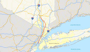
New York State Route 9A (NY 9A) is a state highway in the vicinity of New York City in the United States. Its southern terminus is at the northern end of the Brooklyn–Battery Tunnel in New York City, where it intersects with both Interstate 478 (I-478) and FDR Drive. The northern terminus of NY 9A is at U.S. Route 9 (US 9) in Peekskill. It is predominantly an alternate route of US 9 between New York City and Peekskill; however, in New York City, it is a major route of its own as it runs along the West Side Highway and Henry Hudson Parkway. In Westchester County, NY 9A follows the Briarcliff–Peekskill Parkway.
The origins of NY 9A date back to the 1920s when an alternate route of then-NY 6 from Yonkers to Tarrytown was designated as New York State Route 6A. NY 6 was redesignated as US 9 in 1927; however, NY 6A was not renumbered to NY 9A until the 1930 renumbering of state highways in New York. NY 9A was extended south into New York City in 1934 and north to Ossining in the late 1930s. In 1933, the Briarcliff–Peekskill Parkway opened as New York State Route 404. All of NY 404 was incorporated into an extended NY 9A on January 1, 1949. NY 9A was extended northward to Peekskill in 1967 following the completion of the Croton Expressway and southward to the Brooklyn–Battery Tunnel in the mid-1990s.
Route description
NY 9A begins in Lower Manhattan at the north end of the Brooklyn–Battery Tunnel (I-478) and heads north on the surface West Side Highway and Henry Hudson Parkway, crossing US 9 for the first time at the east end of the George Washington Bridge. After crossing into the Bronx via the Triborough Bridge and Tunnel Authority-owned Henry Hudson Bridge, NY 9A proceeds to leave the parkway at exit 23, joining US 9 on Broadway.[3] The portions of NY 9A between 34th and 72nd streets in Manhattan and from the Henry Hudson Parkway to the New York City line in the Bronx is maintained by the New York City Department of Transportation.[4][5] The concurrency between US 9 and NY 9A runs for 2.87 miles (4.62 km) within the city of Yonkers.[1] All of NY 9A within Yonkers is maintained by the city.[6]
NY 9A separates from US 9 along Ashburton Avenue and heads north as Saw Mill River Road. It parallels the Saw Mill River Parkway through Ardsley and Elmsford, to the west side of Hawthorne. The route meets the southbound New York State Thruway (I-87) at a partial interchange and later meets I-287 (the Cross-Westchester Expressway) at a full interchange that provides a route to the northbound Thruway (I-87).[7] NY 100 merges with NY 9A to form a 3.11-mile (5.01 km) concurrency[1] carrying the names Saw Mill River Road and Briarcliff–Peekskill Parkway, parallel to the Taconic State Parkway. NY 9A exits off this highway along the Briarcliff–Peekskill Parkway, while NY 100 continues straight as Saw Mill River Road. NY 9A merges to form a brief concurrency with US 9 as the Croton Expressway in Ossining just south of the Croton River.[7]
The second concurrency between US 9 and NY 9A runs for 0.65 miles (1 km), with NY 9A leaving the Croton Expressway at Croton Point Avenue in Croton-on-Hudson. The highway heads north along Riverside Avenue and eventually joins old Albany Post Road. After crossing US 9 once more in Cortlandt, NY 9A ends at the Welcher Avenue interchange in southern Peekskill.[7]
History
Origins
Prior to the establishment of the U.S. Highway System, US 9 was designated as NY 6. An alternate route from Yonkers to Tarrytown was assigned the NY 6A designation by 1926. This ran along the present alignment of NY 9A from Yonkers to north of Elmsford, where it turned west on Old Saw Mill River Road, Neperan Road, County House Road and Bedford Road to end at NY 6 in Tarrytown.[8] NY 6 was redesignated as US 9 when U.S. Highways were first posted in New York in 1927; however, NY 6A was not renumbered at this time.[9] It was finally renumbered to NY 9A as part of the 1930 renumbering of state highways in New York.[2]
New York City initially did not mark numbered routes within its limits.[10] In 1932, the New York Automobile Club drafted a plan establishing alignments for several routes through the city. In this plan, NY 9A went south through the Bronx and into Manhattan on Broadway while US 9 used Riverdale Avenue north of 230th Street. As a result, the two routes would have had a short concurrency across Spuyten Duyvil Creek. NY 9A would have split to the south on Tenth Avenue at 218th Street in order to join the Harlem River Drive via Nagle Avenue and Dyckman Street. From there it would head west on 155th Street to Amsterdam Avenue, where it would head south to 79th Street, heading west there to rejoin US 9 at Riverside Drive. US 9 would have continued south through lower Manhattan to Staten Island via the Staten Island Ferry; however, it is unclear whether NY 9A would have continued south with US 9 to lower Manhattan.[11]
The New York Automobile Club released another plan in 1933. This plan made no changes to NY 9A; however, US 9 was changed to use Broadway all the way through the Bronx and to travel to New Jersey by way of the Holland Tunnel.[12] In the final plan implemented in mid-December 1934, no route was assigned to the Harlem River Drive–Amsterdam Avenue corridor. Instead, NY 9A used what had been planned as US 9, splitting at Broadway and Dyckman Street. NY 9A ran south along the west side of Manhattan on Riverside Drive and the West Side Elevated Highway (detouring around an unfinished section via 57th Street, Eleventh Avenue and 48th Street) to end at the entrance and exit plazas of the Holland Tunnel. US 9 was shifted northward to enter New Jersey via the George Washington Bridge.[10]
Westchester County
In Westchester County, Saw Mill River Road originally followed the Saw Mill River Parkway corridor from Eastview to Hawthorne. This section of Saw Mill River Road gained a number c. 1931, becoming part of NY 142, a route that began at NY 100 on the Greenburgh–Mount Pleasant town line and followed Grasslands Road, NY 9A, and Saw Mill River Road north to Hawthorne, where it rejoined NY 100.[13][14] The route went unchanged until it was removed c. 1938.[15][16] Its former routing was split into two routes—an extended NY 141 north of NY 9A and the new NY 100C along Grasslands Road—by 1940.[17] NY 9A was extended northward c. 1939 from Tarrytown to Archville, a small hamlet midway between Tarrytown and Ossining, by way of Sleepy Hollow Road.[18][19]
Farther north, a new highway was built around Ossining from Saw Mill River Road (NY 100) in Briarcliff Manor to US 9 north of Ossining. The highway, known as the Briarcliff–Peekskill Parkway, was completed c. 1933 and initially designated as NY 404.[20][21] On January 1, 1949, NY 9A was altered to continue north along a slightly realigned Saw Mill River Road from NY 100C near Elmsford to the south end of the Briarcliff–Peekskill Parkway in Briarcliff Manor. At this point, NY 9A left Saw Mill River Road and followed the parkway to its end at US 9, supplanting NY 404. The realignment created a 3-mile (5 km) overlap between NY 9A and NY 100 from Hawthorne to Briarcliff Manor and resulted in the truncation of NY 141 back to its previous terminus in Hawthorne.[22]
Construction on the Croton Expressway, the only piece of the failed Hudson River Expressway project that was ever built, began in the mid-1960s.[23][24] It became part of a realigned US 9 when it was completed by 1967. The former surface routing of US 9 along Albany Post Road between Croton-on-Hudson and Buchanan became a northward extension of NY 9A, which reached the old alignment by way of an overlap with US 9 from the north end of the Briarcliff–Peekskill Parkway to Croton-on-Hudson.[24]
New York City
As the Henry Hudson Parkway replaced Riverside Drive in the mid-1930s, NY 9A was moved onto it, eventually using the new parkway to where it crossed US 9 (Broadway) in the Bronx. Here, NY 9A exited the parkway and ran concurrent with US 9 to the split in Yonkers.[16][25] The Brooklyn–Battery Tunnel connecting Manhattan's Battery Park to Brooklyn was completed in 1950.[26] By 1960, an extension of the West Side Elevated Highway south to the Manhattan tunnel portal became part of NY 27A,[27] which had ended in Brooklyn prior to the construction of the tunnel.[28] On January 1, 1970, NY 27A was truncated on its western end to eastern Nassau County while NY 27 was extended northward over NY 27A's former routing through the Battery Tunnel and the West Side Elevated Highway.[29]
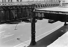
However, by 1973, NY 27 had been cut back to its interchange with the Gowanus Expressway in Brooklyn while I-478 was assigned to both the Battery Tunnel and all of the West Side Elevated Highway south of the Lincoln Tunnel. NY 9A was cut back to the Lincoln Tunnel as a result.[30][31] The extension of I-478 into Manhattan was eliminated following the collapse of part of the Elevated Highway in 1973,[32] an event which led to the demolition of the highway south of 59th Street. Demolition was completed in 1989.[33] NY 9A was shifted onto 12th Avenue, one of the surface streets that the Elevated Highway had run atop of, but was otherwise unaffected as the route's south end was initially kept at the Lincoln Tunnel.[34][35]
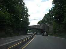
In the mid-1990s, NY 9A was extended south to the Battery Tunnel by way of 12th Avenue and two other streets the Elevated Highway had previously run atop of, West Street and 11th Avenue.[35][36] Construction began in early 1996 on a project to convert the section of NY 9A south of 59th Street into the West Side Highway, a six-lane urban boulevard with a parkway-style median and decorative lightposts. The first of the project's seven segments—between Clarkson and Horatio streets in the Greenwich Village neighborhood—was completed in 1998.[37] Completion of the project was originally set for October 2001; however, it was delayed for years due to damage caused by the September 11 attacks.[38] It is expected to be finished by the end of 2013.[39]
Major intersections
| County | Location | mi[1] | km | Destinations | Notes |
|---|---|---|---|---|---|
| New York | Manhattan | 0.00 | 0.00 | Northern terminus of I-478; southern terminus of FDR Drive | |
| Eastern terminus of I-78 | |||||
| Eastern terminus of NY 495 | |||||
| 5.29 | 8.51 | Southern terminus of NY 9A / Henry Hudson Parkway overlap; southern terminus of Henry Hudson Parkway | |||
| 10.21 | 16.43 | ||||
| Bronx | The Bronx | 15.34 | 24.69 | Northern terminus of NY 9A / Henry Hudson Parkway overlap; southern terminus of US 9 / NY 9A overlap | |
| Westchester | Yonkers | 18.21 | 29.31 | Northern terminus of US 9 / NY 9A overlap | |
| 20.19 | 32.49 | ||||
| Ardsley | 24.17 | 38.90 | Exit 7 (I-87 / Thruway) | ||
| Greenburgh | 25.58 | 41.17 | Western terminus of NY 100B | ||
| Elmsford | 28.13 | 45.27 | |||
| 28.41 | 45.72 | Exit 2 (I-287) | |||
| Greenburgh–Mount Pleasant town line | 29.54 | 47.54 | Western terminus of NY 100C | ||
| Mount Pleasant | 30.94 | 49.79 | |||
| 32.02 | 51.53 | Western terminus of NY 141 | |||
| 32.22 | 51.85 | Hamlet of Hawthorne; southern terminus of NY 9A / NY 100 overlap | |||
| 33.35 | 53.67 | ||||
| Briarcliff Manor–Mount Pleasant village/town line | 35.33 | 56.86 | Northern terminus of NY 9A / NY 100 overlap | ||
| Village of Ossining | 36.85 | 59.30 | |||
| Town of Ossining | 38.20 | 61.48 | |||
| 39.71 | 63.91 | Southern terminus of US 9 / NY 9A overlap | |||
| Croton-on-Hudson | 40.36 | 64.95 | Northern terminus of US 9 / NY 9A overlap | ||
| Cortlandt | 43.99 | 70.80 | |||
| Peekskill | 47.25 | 76.04 | |||
1.000 mi = 1.609 km; 1.000 km = 0.621 mi
| |||||
See also
- U.S. Route 9 Business (now Route 139), which continued NY 9A back to its parent in Jersey City, New Jersey
References
- ↑ 1.0 1.1 1.2 1.3 "2008 Traffic Data Report for New York State" (PDF). New York State Department of Transportation. June 16, 2009. pp. 106–107. Retrieved December 7, 2009.
- ↑ 2.0 2.1 Automobile Legal Association (ALA) Automobile Green Book, 1930–31 and 1931–32 editions, (Scarborough Motor Guide Co., Boston, 1930 and 1931). The 1930–31 edition shows New York state routes prior to the 1930 renumbering
- ↑ 2008 Road Atlas (Map). American Map. p. 80.
- ↑ "New York County Inventory Listing" (CSV). New York State Department of Transportation. October 1, 2009. Retrieved December 7, 2009.
- ↑ "Bronx County Inventory Listing" (CSV). New York State Department of Transportation. October 1, 2009. Retrieved December 7, 2009.
- ↑ County and State Roads and Parks (PDF) (Map). Westchester County Department of Public Works. 2009. Retrieved December 7, 2009.
- ↑ 7.0 7.1 7.2 Google (April 9, 2013). "overview map of NY 9A" (Map). Google Maps. Google. Retrieved April 9, 2013.
- ↑ Official Map Showing State Highways and other important roads (Map). Cartography by Rand McNally and Company. State of New York Department of Public Works. 1926.
- ↑ Automobile Blue Book 1 (1927 ed.). Chicago: Automobile Blue Book, Inc. 1927. This edition shows U.S. Routes as they were first officially signed in 1927.
- ↑ 10.0 10.1 "Mark Ways in the City". The New York Times. December 16, 1934. p. XX12.
- ↑ "Through Routes Mapped". The New York Times. March 20, 1932. p. XX6.
- ↑ "Routes Through New York City". The New York Times. November 12, 1933.
- ↑ Road Map of New York (Map). Cartography by General Drafting. Standard Oil Company of New York. 1930.
- ↑ New York (Map). Cartography by H.M. Gousha Company. Kendall Refining Company. 1931.
- ↑ Shell Road Map – New York (Map). Cartography by H.M. Gousha Company. Shell Oil Company. 1937.
- ↑ 16.0 16.1 New York Road Map for 1938 (Map). Cartography by General Drafting. Esso. 1938.
- ↑ New York Info-Map (Map). Cartography by Rand McNally and Company. Gulf Oil Company. 1940.
- ↑ Thibodeau, William A. (1938). The ALA Green Book (1938–39 ed.). Automobile Legal Association.
- ↑ New York (Map). Cartography by General Drafting. Standard Oil Company. 1939.
- ↑ Staff (2012). "NBI Structure Number: 1006210". National Bridge Inventory. Federal Highway Administration. Retrieved April 6, 2013.
- ↑ Texaco Road Map – New York (Map). Cartography by Rand McNally and Company. Texas Oil Company. 1934.
- ↑ "State Announces Changes in County; Routes 28 and 209". The Kingston Daily Freeman (Kingston, New York). December 9, 1948. p. 1. Retrieved August 20, 2014 – via Newspapers.com.

- ↑ New York and Metropolitan New York (Map). Cartography by Rand McNally and Company. Sinclair Oil Corporation. 1964.
- ↑ 24.0 24.1 Gousha Road Atlas (Map). H.M. Gousha Company. 1967. Retrieved December 29, 2009.
- ↑ Road Map & Historical Guide – New York (Map). Cartography by Rand McNally and Company. Sun Oil Company. 1935.
- ↑ Falk, Sam (May 25, 1950). "Tube to Brooklyn Will Open Today". The New York Times. p. 30. Retrieved December 29, 2009.
- ↑ New York and New Jersey Tourgide Map (Map). Cartography by Rand McNally and Company. Gulf Oil Company. 1960.
- ↑ New York (Map). Cartography by Rand McNally and Company. Socony-Vacuum Oil Company. 1950.
- ↑ State of New York Department of Transportation (January 1, 1970). Official Description of Touring Routes in New York State (PDF). Retrieved December 29, 2009.
- ↑ New York (Map) (1973 ed.). Cartography by H.M. Gousha Company. Shell Oil Company. 1973.
- ↑ Central Park Digital Raster Quadrangle (Map). 1:24,000. New York State Department of Transportation. 1975. Retrieved December 28, 2009.
- ↑ Perlmutter, Emanuel (December 17, 1973). "Indefinite Closing Is Set For West Side Highway; Northbound Road Closed". The New York Times. p. 41. Retrieved December 29, 2009.
- ↑ Levine, Richard (January 6, 1989). "Highway's Demise: Nightmare for Drivers". The New York Times. p. B1. Retrieved December 29, 2009.
- ↑ New York (Map). Rand McNally and Company. 1985. ISBN 0-528-91040-X.
- ↑ 35.0 35.1 "1996 Traffic Volume Report for New York State". New York State Department of Transportation. p. 30.
- ↑ New York (Map). Rand McNally and Company. 1995. ISBN 0-528-96764-9.
- ↑ Stamler, Bernard (June 21, 1998). "Neighborhood Report: West Side; Route 9A: Long Overdue but Ahead of Schedule". The New York Times. p. 145. Retrieved December 29, 2009.
- ↑ "Governor, Mayor Open West Street Promenade South" (Press release). New York State Department of Transportation. July 7, 2006. Retrieved April 9, 2013.
- ↑ "9A West Street Promenade". New York State Department of Transportation. Retrieved April 9, 2013.
External links
| Wikimedia Commons has media related to New York State Route 9A. |
- New York State Route 9A at Alps' Roads • New York Routes • New York State Highway Termini
- NYCRoads: Briarcliff–Peekskill Parkway – includes formerly proposed extension off NY 9A
- NY 9A (Greater New York Roads)
| ||||||||||