New York State Route 72
| ||||
|---|---|---|---|---|
|
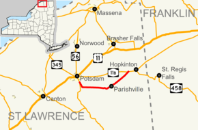
Map of St. Lawrence County and vicinity with NY 72 highlighted in red | ||||
| Route information | ||||
| Maintained by NYSDOT | ||||
| Length: | 15.36 mi[1] (24.72 km) | |||
| Existed: | 1930[2] – present | |||
| Major junctions | ||||
| West end: |
| |||
| East end: |
| |||
| Location | ||||
| Counties: | St. Lawrence | |||
| Highway system | ||||
| ||||
New York State Route 72 (NY 72) is a state highway in the North Country of New York in the United States. The road is an east–west highway located entirely within the eastern part of St. Lawrence County. The western terminus of NY 72 is at an intersection with NY 56 in the town of Potsdam, south of the village of Potsdam. Its eastern terminus is at a junction with NY 11B west of the community of Hopkinton in the town of Hopkinton.
The NY 72 designation dates back to 1930; however, the route initially followed an entirely different alignment from Potsdam to Hopkinton and was much longer than it is now, extending as far east as Brighton, Franklin County. It was shifted onto its present routing by the 1940s and truncated to its current length in the 1970s.
Route description
NY 72 begins at an intersection with NY 56 southwest of the Potsdam village limits in the town of the same name in northern St. Lawrence County. The route heads southeast on a line to Stafford Corners, a small hamlet located on the Potsdam-Parishville, then turns east to serve the hamlets of Parishville Center, located at the junction of NY 72 and Ashton/Sinclair Roads,[3] and Parishville, located on the west branch of the St. Regis River. Within Parishville, NY 72, named Main Street, crosses over the river and intersects the southern end of County Route 47 (CR 47), a connector leading to U.S. Route 11 (US 11) and NY 11C 10 miles (16 km) to the north.[4][5]

East of the hamlet of Parishville, NY 72 turns to the northeast and proceeds on a linear alignment through the towns of Parishville and Hopkinton toward the hamlet of Hopkinton in the northeast corner of the town of the same name.[4] Upon reaching the community, the route terminates at NY 11B, the primary east–west route through the hamlet.[6]
History
The primary east–west roadway connecting Potsdam to Brighton via Southville, Hopkinton, and Saint Regis Falls (modern NY 11B and NY 458) was originally designated as part of NY 2A from Potsdam to Nicholville and as part of NY 56 from Nicholville to Brighton in the mid-1920s. NY 56 initially continued northwestward from Nicholville to Massena by way of Lawrenceville, North Lawrence, and Winthrop.[7][8] When NY 2 was redesignated as US 11 in 1927, the NY 2A designation was eliminated and replaced with a rerouted NY 56 from Potsdam to Nicholville.[9] NY 56 was truncated to end in Potsdam as part of the change.[10] In the 1930 renumbering of state highways in New York, NY 56 was renumbered to NY 72[2] while an alternate routing of NY 72 between Potsdam and Hopkinton via Parishville was assigned NY 72A.[11]
When NY 11B was assigned in the renumbering, it was simply a north–south connector between Nicholville and Lawrenceville.[2] By the following year, NY 11B was extended west from Nicholville to Potsdam, creating a lengthy overlap with NY 72 between the two locations.[12] The length of the concurrency was significantly reduced in the early 1940s when NY 72 was rerouted to follow NY 72A between Potsdam and Hopkinton.[13][14] The overlap was eliminated c. 1973 when NY 72 was truncated to the west end of its overlap with NY 11B. The portion of former NY 72 southeast of Nicholville became NY 458.[15][16]
Major intersections
The entire route is in St. Lawrence County.
| Location | mi[1] | km | Destinations | Notes | |
|---|---|---|---|---|---|
| Town of Potsdam | 0.00 | 0.00 | |||
| Parishville | 8.59 | 13.82 | CR 47 | Hamlet of Parishville | |
| Hopkinton | 15.36 | 24.72 | Hamlet of Hopkinton | ||
| 1.000 mi = 1.609 km; 1.000 km = 0.621 mi | |||||
See also
- New York Roads portal
References
- ↑ 1.0 1.1 "2008 Traffic Volume Report for New York State" (PDF). New York State Department of Transportation. June 16, 2009. p. 130. Retrieved January 31, 2010.
- ↑ 2.0 2.1 2.2 Dickinson, Leon A. (January 12, 1930). "New Signs for State Highways". The New York Times. p. 136.
- ↑ Potsdam Quadrangle - New York - St. Lawrence Co. (Map). 1 : 24,000. 7.5 Minute Series (Topographic). United States Geological Survey. 1964. Retrieved February 17, 2008.
- ↑ 4.0 4.1 Parishville Quadrangle - New York - St. Lawrence Co. (Map). 1:24,000. 7.5 Minute Series (Topographic). United States Geological Survey. 1980. Retrieved February 17, 2008.
- ↑ Google (February 17, 2008). "Parishville, New York" (Map). Google Maps. Google. Retrieved February 17, 2008.
- ↑ Google (February 17, 2008). "Hopkinton, New York" (Map). Google Maps. Google. Retrieved February 17, 2008.
- ↑ "New York's Main Highways Designated by Numbers". The New York Times. December 21, 1924. p. XX9.
- ↑ Official Map Showing State Highways and other important roads (Map). Cartography by Rand McNally and Company. State of New York Department of Public Works. 1926.
- ↑ Automobile Blue Book 1 (1927 ed.). Chicago: Automobile Blue Book, Inc. 1927. This edition shows U.S. Routes as they were first officially signed in 1927.
- ↑ New York in Soconyland (Map). Cartography by General Drafting. Standard Oil Company of New York. 1929.
- ↑ Automobile Legal Association (ALA) Automobile Green Book, 1930–31 and 1931–32 editions, (Scarborough Motor Guide Co., Boston, 1930 and 1931). The 1930–31 edition shows New York state routes prior to the 1930 renumbering
- ↑ New York (Map). Cartography by H.M. Gousha Company. Kendall Refining Company. 1931.
- ↑ New York Info-Map (Map). Cartography by Rand McNally and Company. Gulf Oil Company. 1940.
- ↑ New York with Pictorial Guide (Map). Cartography by General Drafting. Esso. 1942.
- ↑ New York and New Jersey Tourgide Map (Map) (1972 ed.). Cartography by Rand McNally and Company. Gulf Oil Company. 1972.
- ↑ New York (Map) (1973 ed.). Cartography by H.M. Gousha Company. Shell Oil Company. 1973.
External links
| Wikimedia Commons has media related to New York State Route 72. |
- New York State Route 72 at New York Routes • New York State Highway Termini

