New York State Route 214
| ||||
|---|---|---|---|---|
|
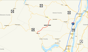
Map of eastern New York with NY 214 highlighted in red | ||||
| Route information | ||||
| Maintained by NYSDOT | ||||
| Length: | 12.48 mi[1] (20.08 km) | |||
| Existed: | 1930[2] – present | |||
| Major junctions | ||||
| South end: |
| |||
| North end: |
| |||
| Location | ||||
| Counties: | Ulster, Greene | |||
| Highway system | ||||
| ||||
New York State Route 214 (NY 214) is a short but scenic state highway in the heart of the Catskill Park. It runs north–south from near the hamlet of Phoenicia up near an old railroad route into the narrow pass known as Stony Clove Notch, then down into the upper Schoharie Creek valley to end near Hunter.
Route description

NY 214 begins at an intersection with NY 28 in the town of Shandaken as the latter runs along the Esopus Creek. NY 214 gains the moniker of Main Street, climbing downhill into the hamlet of Phoenicia, crossing a tributary of Esopus Creek, Stony Clove Creek, into the center of the community. A block after the water crossing, NY 214 turns northwest off Main Street, becoming a two-lane commercial street, bypassing the downtown section of Phoenicia, now paralleling the waterway. NY 214 soon leaves Phoenicia, bending northeast along Stony Clove Creek, crossing northeast along the sides of the nearby mountains, reaching the hamlet of Chichester, where it becomes a two-lane residential road in the middle of the notch.[3]
NY 214 continues northeast out of Chichester, crossing through the town of Shandaken, remaining a two-lane roadway. A short distance northeast of Chichester, the route crosses out of Ulster County and into Greene County. NY 214 continues northeast through the town of Hunter. Reaching the hamlet of Lanesville, the route becomes a rural mountainside road through various mountains of the Catskill High Peaks. For a short distance along the route east of Lanesville, the route bends eastward rather than northeast, reaching the hamlet of Edgewood, which consists of a few homes and a junction with Notch Hill Road. At this junction, NY 214 turns northward between Plateau and Hunter mountains, becoming a two-lane woods road.[3]
NY 214 passes a small pond of Stony Clove Notch, continuing north and turning northeast near Higgins Road. After the northeastern turn, the route junctions with the southern terminus of County Route 83 (CR 83 or Ski Bowl Road). The route winds out and becomes a flat area through Hunter, reaching a junction with NY 23A in the hamlet of Hunter, just west of Tannersville.[3]
History
A track of some kind had long existed up NY 214's present-day course, although it was suitable only for personal foot traffic, which had to pass through Stony Clove Notch in single file as it was extremely narrow at the time. In the 1840s tanner Charles Edwards widened it at great personal expense so that at least wagons could get through, serving not only his tanneries in Hunter but the lumber companies in Lanesville and Chichester as well.
In 1873 the Stoney [sic] Clove Turnpike was incorporated to make further road improvements. In 1881, the narrow gauge railway was built along the road. The road was taken over by the state of New York in the late 1920s and designated as NY 214 as part of the 1930 renumbering of state highways in New York.[2][4]
Major intersections
| County | Location | mi[1] | km | Destinations | Notes |
|---|---|---|---|---|---|
| Ulster | Shandaken | 0.00 | 0.00 | Hamlet of Phoenicia | |
| Greene | Town of Hunter | 12.48 | 20.08 | ||
| 1.000 mi = 1.609 km; 1.000 km = 0.621 mi | |||||
See also
- New York Roads portal
References
- ↑ 1.0 1.1 "2008 Traffic Volume Report for New York State" (PDF). New York State Department of Transportation. June 16, 2009. p. 189. Retrieved February 1, 2010.
- ↑ 2.0 2.1 Road Map of New York (Map). Cartography by General Drafting. Standard Oil Company of New York. 1930.
- ↑ 3.0 3.1 3.2 Microsoft; Nokia (March 11, 2013). "overview map of NY 214" (Map). Bing Maps. Microsoft. Retrieved March 11, 2013.
- ↑ Official Map Showing State Highways and other important roads (Map). Cartography by Rand McNally and Company. State of New York Department of Public Works. 1926.
External links
| Wikimedia Commons has media related to New York State Route 214. |
- New York State Route 214 at Alps' Roads • New York Routes • New York State Highway Termini

