New Mexico State Road 597
| ||||
|---|---|---|---|---|
| Route information | ||||
| Maintained by NMDOT | ||||
| Length: | 0.447 mi[1] (0.719 km) | |||
| Major junctions | ||||
| South end: |
| |||
| North end: | 4 Corners Road at the Four Corners Monument | |||
| Location | ||||
| Counties: | San Juan | |||
| Highway system | ||||
| ||||

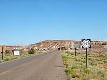
State Road 597 (NM 597) is a 0.447-mile (719 m) long state highway located entirely on the Navajo Nation, which is located in San Juan County, New Mexico, United States. The highway serves to link the U.S. Route 160 (US 160) to the Four Corners Monument. The highway is the second shortest highway in New Mexico, with the shortest being NM 446 measuring 0.250 miles (402 m).
Route description
NM 597 begins at a t-intersection with US 160 in extreme northwestern San Juan County, New Mexico. Traveling northwest the two-lane highway passes through desert terrain to its northern terminus at a toll booth. After passing the toll booth, the road becomes 4 Corners Road,[2] which encircles the Four Corners Monument.[3] The highway's posted speed limit is 15 miles per hour (24 km/h).
The highway is the second shortest highway in New Mexico, with the shortest being NM 446 measuring 0.250 miles (402 m).[1]
Major intersections
The entire route is in San Juan County.
| Location | mi[1] | km | Destinations | Notes | |
|---|---|---|---|---|---|
| 0.000 | 0.000 | Southern terminus | |||
| 0.447 | 0.719 | 4 Corners Road | Northern terminus, Four Corners Monument | ||
| 1.000 mi = 1.609 km; 1.000 km = 0.621 mi | |||||
See also
References
- ↑ 1.0 1.1 1.2 "Posted Route–Legal Description" (PDF). New Mexico Department of Transportation. March 16, 2010. p. 108. Retrieved December 18, 2013.
- ↑ Google (November 26, 2010). "NM 597" (Map). Google Maps. Google. Retrieved November 26, 2010.
- ↑ "Four Corners Monument". Navajo Parks & Recreation. Retrieved November 28, 2010.
External links
Route map: Bing
![]() Geographic data related to New Mexico State Road 597 at OpenStreetMap
Geographic data related to New Mexico State Road 597 at OpenStreetMap
