New Hampshire Route 4
| ||||
|---|---|---|---|---|
|
Map of Strafford County in southeastern New Hampshire with NH 4 highlighted in red | ||||
| Route information | ||||
| Maintained by NHDOT | ||||
| Length: | 3.78 mi[1] (6.08 km) | |||
| Major junctions | ||||
| West end: |
| |||
| East end: |
| |||
| Location | ||||
| Counties: | Strafford | |||
| Highway system | ||||
| ||||

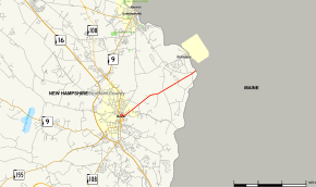
New Hampshire Route 4 (abbreviated NH 4) is a 3.78-mile (6.08 km) state highway located in eastern Strafford County, New Hampshire. It runs from downtown Dover northeast through Rollinsford to the Maine state border, where it continues as Maine State Route 4 in South Berwick.
For most of its length NH 4 is signed as an east-west highway. Signage in downtown Dover over its concurrency with NH 9 and NH 108 is inconsistent as it is sometimes signed north-south. It follows a generally southwest-to-northeast alignment.
NH 4 is not the same road as nearby U.S. Route 4, which also enters the Dover city limits. This is the only instance of two non-linked highways sharing a number in the state (Maine State Route 113 crosses into New Hampshire, very near NH 113, but remains under MaineDOT maintenance).
Route description
Western terminus
The western terminus of NH 4 is not readily apparent, as signage at the intersection of Silver Street and Central Avenue seems to indicate NH 4 continuing westbound along NH 9; however, no further signage for NH 4 exists west of this point so it is likely this intersection is the actual terminus.
Downtown Dover
From the intersection of NH 4, NH 9, and NH 108, the three routes run concurrently for 0.5 miles (0.80 km), until NH 4 splits off in the center of town. In the eastbound direction, NH 4 is signed along Portland Avenue leaving town. However, in the westbound direction, the mainline of NH 4 is signed along Chapel Street, Saint John Street, and Broadway, while Portland Avenue westbound is signed as a truck route. This does not seem to be an official state designation, and most maps show NH 4 solely along Portland Avenue.
Rollinsford
After less than a mile, NH 4 crosses into the town of Rollinsford. NH 4 is the only route to pass through Rollinsford and runs in the south-central part of town for about 2.5 miles. NH 4 then crosses the Salmon Falls River into the town of South Berwick, ME and becomes Maine State Route 4. NH 4 is named Portland Avenue in Rollinsford.
History

NH 4 (and SR 4 in Maine by extension) was originally intended to be a part of US 4, from which it derives its number. However, US 4 was ultimately routed from Durham to the southern tip of Dover and along the Spaulding Turnpike to Portsmouth. The number 4 was retained in Maine and, for continuity's sake, New Hampshire as well. The result is two New Hampshire highways sharing the same number.
Major intersections
The entire route is in Strafford County.
| Location | mi | km | Destinations | Notes | |
|---|---|---|---|---|---|
| Dover | 0.000 | 0.000 | Western terminus of NH 4 | ||
| 0.5 | 0.8 | Northern terminus of concurrency | |||
| Rollinsford | 3.78 | 6.08 | Continuation into Maine | ||
1.000 mi = 1.609 km; 1.000 km = 0.621 mi
| |||||