New Hampshire Route 16
| |||||||
|---|---|---|---|---|---|---|---|
|
Spaulding Turnpike (Portsmouth–Milton) White Mountain Highway (Milton–Gorham) | |||||||
|
Map of New Hampshire with NH 16 highlighted in red | |||||||
| Route information | |||||||
| Maintained by NHDOT | |||||||
| Length: | 154.771 mi[1] (249.080 km) | ||||||
| Existed: | 1922 (as New England Route 16) – present | ||||||
| Major junctions | |||||||
| South end: |
| ||||||
| North end: |
| ||||||
| Location | |||||||
| Counties: | Rockingham, Strafford, Carroll, Coos | ||||||
| Highway system | |||||||
| |||||||
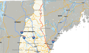
New Hampshire Route 16 (abbreviated NH 16) is a 149.75-mile (241.00 km) long north–south highway in the U.S. state of New Hampshire. Much of its length is close to the border with Maine. NH 16 is the main route from the Seacoast region north to the Lakes Region and the White Mountains. The section from Portsmouth to Milton is a controlled-access toll highway known as the Spaulding Turnpike. Between the Portsmouth Circle and Dover Point, US 4 is also routed along the Turnpike. The northern section of Route 16 is called the White Mountain Highway.
The southern terminus of Route 16 is at the Portsmouth Circle, intersecting with Interstate 95 and the US 1 Bypass. The northern terminus is at the Maine state line in Wentworth's Location, where it becomes Maine State Route 16.
There are three secondary state routes related to Route 16. Two loops from NH 16 are designated as New Hampshire Route 16A, and the northern NH 16A connects to both ends of the New Hampshire Route 16B loop.
Route description
From the south headed north, Route 16 begins in Portsmouth at the western exit from the Portsmouth Circle, where the Spaulding Turnpike also begins, and US 4 reaches its eastern terminus. The US 4/NH 16/Spaulding Turnpike concurrency leaves the circle as two lanes. A short distance north, the right lane leaves as local traffic, and through traffic merges down to one lane which then merges with two lanes of traffic from I-95 North to become a three lane freeway. The road then travels north through Newington past Portsmouth International Airport at Pease (formerly the Pease Air Force Base), then merges from three to two lanes before turning northwest to cross the Little Bay Bridge over the confluence of Great Bay and the Piscataqua River. North of the bridge, US 4 leaves NH 16 and travels west towards Concord.
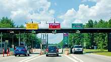
Shortly after the US 4 interchange is the Dover toll plaza, with a toll of 75¢ for passenger cars in either direction. The road continues north, passing to the west of the downtown areas of Dover, Somersworth, and Rochester, known locally as the "tri-city area". US 202 joins the concurrency for a short distance in Rochester on its way to Maine. Two exits later, NH 11 joins the concurrency, entering eastbound with traffic from the southern Lake Winnipesaukee area, and leaves NH 16 along with US 202 at the next exit. Traveling north into Milton, the Spaulding Turnpike ends at an intersection that marks the northern terminus of NH 125. Route 16 continues north, no longer a limited access road, and now with the moniker of the White Mountain Highway.
From Milton, Route 16 continues to roughly parallel the Maine border. In Wakefield, the road takes a turn to the northwest heading towards Ossipee. Route 16 turns back to a northerly heading near Tamworth, then makes a turn eastward in Albany to reach Conway. Route 16 turns north again in Conway, entering the region known as the Mount Washington valley, and begins a concurrency with US 302 between the center of Conway and the village of North Conway. North of North Conway, in Bartlett, the southern Route 16A loop departs and rejoins NH 16/US 302 before the road makes a westward hook.
In Glen, Route 16 turns north from US 302 and heads toward Jackson, where the northern NH 16A loop is located, as well as NH 16B, which is a loop that begins and ends at NH 16A. Continuing north, NH 16 passes through Pinkham Notch, to the east of Mount Washington, New Hampshire's highest peak, and intersecting with the base of the Mount Washington Auto Road. Route 16 meets US 2 in Gorham, sharing a short concurrency along Gorham's Main Street. Leaving US 2, Route 16 continues north along the Androscoggin River to the city of Berlin, and then turns northeast toward the town of Errol. From Errol NH 16 continues northeast to Wentworth's Location and the Maine border. After crossing the border the road becomes ME 16 and heads east toward Rangeley. From there, the road continues for approximately 200 miles (320 km) until its terminus in Orono, Maine. Between the New Hampshire and Maine segments of Route 16, the route stretches for approximately 350 miles (560 km).
History

From 1922 until 1926, most of the original surface alignment of Route 16, from Portsmouth to the intersection with Route 26 in Errol, was known as New England Interstate Route 16, the "East Side Road". In 1926, the New England Routes were superseded by the system of United States Numbered Highways, and many of the New England Routes, including Route 16, became state highways with the same number.
Route 16 used to serve as a non-tolled alternative to the Spaulding Turnpike between Dover and Rochester. In the early 1990s, NHDOT rerouted Route 16 onto the turnpike as a concurrency for the full length of the turnpike. Route 16's old routing is now made up of several different roads. After crossing the bridge from Newington to Dover, the old NH 16 alignment traveled along Dover Point Road, an unnumbered city road, into downtown Dover to an intersection with NH 108, where that route used to end. Route 108 was extended along Dover's Central Ave. and further north into Rochester to the present end of NH 108 at NH 125 (map). From there, Route 125 was extended along Route 16's former route north to the end of the Spaulding Turnpike in Milton, and NH 125 now carries the White Mountain Highway designation between Rochester and Milton (map).
The Conway Bypass is a proposed re-routing of Route 16 around Conway and North Conway. While preliminary work has been done, the bypass is still in planning stages.
Junction list
Surface road section
| County | Location[1][3] | mi[1][3] | km | Destinations | Notes |
|---|---|---|---|---|---|
| Strafford | Milton | 33.259 | 53.525 | Northern terminus of Spaulding Turnpike | |
| Carroll | Wakefield | 34.763 | 55.946 | Northern terminus of NH 125 | |
| 38.608 | 62.134 | ||||
| Ossipee | 48.816 | 78.562 | Eastern terminus of NH 171 | ||
| 50.477 | 81.235 | Northern terminus of NH 28 | |||
| 54.678 | 87.996 | Interchange; southern end of concurrency with NH 25 | |||
| 60.297 | 97.039 | Northern end of NH 25 concurrency | |||
| 60.557 | 97.457 | Southern terminus of NH 41 | |||
| Tamworth | 64.549 | 103.882 | |||
| Albany | 74.436 | 119.793 | Southern end of concurrency with NH 113 | ||
| Conway | 75.580 | 121.634 | Eastern terminus of NH 112 | ||
| 76.333 | 122.846 | Northern terminus of NH 153 | |||
| 76.405 | 122.962 | Northern end of concurrency with NH 113 | |||
| 79.248 | 127.537 | Southern end of concurrency with US 302 | |||
| Bartlett | 83.896 | 135.018 | Southern terminus of NH 16A | ||
| 86.203 | 138.730 | Northern terminus of NH 16A | |||
| 87.336 | 140.554 | Northern end of concurrency with US 302 | |||
| Jackson | 89.591 | 144.183 | Southern terminus of NH 16A | ||
| 90.062 | 144.941 | Northern terminus of NH 16A | |||
| Coos | Gorham | 109.695 | 176.537 | Southern end of concurrency with US 2 | |
| 111.068 | 178.747 | Northern end of concurrency with US 2 | |||
| Berlin | 116.106 | 186.854 | Eastern terminus of NH 110 | ||
| Milan | 124.120 | 199.752 | Eastern terminus of NH 110B | ||
| Dummer | 128.188 | 206.299 | Eastern terminus of NH 110A | ||
| Errol | 145.639 | 234.383 | Southern end of concurrency with NH 26 | ||
| 145.935 | 234.860 | Northern end of concurrency with NH 26 | |||
| Wentworth's Location | 154.771 | 249.080 | Continuation into Maine | ||
1.000 mi = 1.609 km; 1.000 km = 0.621 mi
| |||||
Suffixed routes
New Hampshire Route 16A
New Hampshire Route 16A is a designation held by two separate state highways in New Hampshire. Although not directly connected, the two routes are linked by their parent route, New Hampshire Route 16.
Southern segment
| |
|---|---|
| Location: | Bartlett |
| Length: | 2.484 mi[1] (3.998 km) |

The southern segment of Route 16A is a loop road, known locally as the Intervale Resort Loop, in the town of Bartlett. It splits off from U.S. Route 302 and Route 16, runs parallel to that highway for 2.484 miles (3.998 km), then rejoins US-302 and Route 16..
Officially, this section of Route 16A is also designated U.S. Route 302 Business, but it is not signed as such anywhere along its route.[4] This is a rare instance of a hidden route in New Hampshire, and is interesting in that a duplicate state numbering has been given precedence over a unique federal one.
Northern segment
| |
|---|---|
| Location: | Jackson |
| Length: | 1.029 mi[1] (1.656 km) |
The northern segment of Route 16A is a loop road in Jackson that is slightly more than a mile long. This road leaves Route 16, travels east to meet both the southern and northern termini of New Hampshire Route 16B (separated by merely 500 feet) and returns to Route 16, passing through the Wentworth Golf Club. The local name for this route is Village Road, and its total length is 1.029 miles (1.656 km).[4][5]
New Hampshire Route 16B
| |
|---|---|
| Location: | Jackson |
| Length: | 5.381 mi[1] (8.660 km) |
New Hampshire Route 16B (abbreviated NH 16B) is a 5.381-mile-long (8.660 km) long state highway located entirely in Jackson, Carroll County, New Hampshire. Although the road is signed as north–south, in reality, NH 16B is a nearly-complete loop, beginning and ending at intersections with New Hampshire Route 16A roughly 500 feet (150 m) apart. Heading counterclockwise on NH 16B from NH 16A, NH 16B is known as Black Mountain Road, Moody Farm Road, and Carter Notch Road. The entire route has also been known as Five Mile Circuit Road.[6]
In addition to its present designation, NH 16B has been assigned to several old alignments of NH 16, but those other routes are no longer signed as such.
In Ossipee, NH 16B was once the designation for an old alignment of NH 16 through the village of Center Ossipee that has been bypassed by the present NH 16 southwest of Ossipee Lake. The route, 2.52 miles (4.06 km) in length, is still called "Route 16B" on street blade signs.[7][8]
Two other roads have also held the NH 16B designation. One is a local road called Old Rochester Road in Somersworth and Old Dover Road in Rochester, paralleling the Spaulding Turnpike in those two towns from NH 108 to NH 125. There is no longer any signage along the road indicating that the road was designated NH 16B.[7][9]
The other road followed what is now New Hampshire Route 125 between New Hampshire Route 16 near Union and New Hampshire Route 153 in Union, as well as NH 153 from NH 125 north to NH 16 in Wakefield. The section of NH 125 in Carroll County is still shown as NH 16B on maps.[7][10]
See also
References
- ↑ 1.0 1.1 1.2 1.3 1.4 1.5 Bureau of Planning & Community Assistance (February 20, 2015). "NH Public Roads". Concord, New Hampshire: New Hampshire Department of Transportation. Retrieved April 7, 2015.
- ↑ Google (2006-09-29). "Wentworth's Location, NH" (Map). Google Maps. Google. Retrieved 2006-09-29.
- ↑ 3.0 3.1 Bureau of Planning & Community Assistance (April 3, 2015). "Nodal Reference 2015, State of New Hampshire". New Hampshire Department of Transportation. Retrieved April 7, 2015.
- Town of Milton, Strafford County
- Town of Wakefield, Carroll County
- Town of Ossipee, Carroll County
- Town of Tamworth, Carroll County
- Town of Albany, Carroll County
- Town of Conway, Carroll County
- Town of Bartlett, Carroll County
- Town of Jackson, Carroll County
- Town of Gorham, Coos County
- City of Berlin, Coos County
- Town of Milan, Coos County
- Town of Dummer, Coos County
- Town of Errol, Coos County
- Town of Wentworth's Location, Coos County
- ↑ 4.0 4.1 New Hampshire DOT Route Logs
- ↑ Google (June 8, 2009). "map of northern segment" (Map). Google Maps. Google. Retrieved June 8, 2009.
- ↑ "Town of Jackson - Street Map" (PDF). Town of Jackson website. Retrieved February 18, 2009.
- ↑ 7.0 7.1 7.2 New Hampshire Routes 1-25
- ↑ Google (June 8, 2009). "map of former Ossipee alignment" (Map). Google Maps. Google. Retrieved June 8, 2009.
- ↑ Google (June 8, 2009). "map of former Somersworth and Rochester alignment" (Map). Google Maps. Google. Retrieved June 8, 2009.
- ↑ Google (June 8, 2009). "map showing NH 125 as NH 16B" (Map). Google Maps. Google. Retrieved June 8, 2009.
External links
| Wikimedia Commons has media related to New Hampshire Route 16. |