Neville Park Loop
Neville Park Loop | |
|---|---|
 | |
| Location |
Queen Street East at Nursewood Road Toronto, Ontario Canada |
| Coordinates | 43°40′25.5″N 79°16′53″W / 43.673750°N 79.28139°WCoordinates: 43°40′25.5″N 79°16′53″W / 43.673750°N 79.28139°W |
| Owned by | Toronto Transit Commission |
| History | |
| Opened | 1922 |
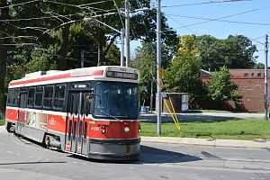
Neville Park Loop is the eastern terminus of the 501 Queen streetcar line, the longest streetcar route of the Toronto Transit Commission (TTC).[1] It is located at the southwest corner of Queen Street East and Nursewood Road in The Beaches neighbourhood of Toronto.
Streetcars enter eastbound and loop anticlockwise to exit at Nursewood Road and turn north to Queen Steet where they return westbound.
History
The loop was constructed in 1922 by the newly created Toronto Transportation Commission, which had taken over and amalgamated existing ageing streetcar systems within the city limits.[2] For that reason the line ends here at the easterly boundary of what had been the old City of Toronto and the westerly boundary of Scarborough, Ontario.
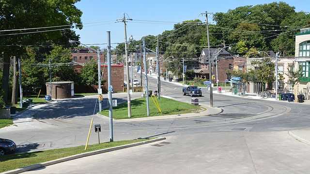
On Neville Park Boulevard south of Queen Street there remains a short section of track running towards the lake where there once was a wye.[3]
Services
Although this is the terminus for 501 Queen streetcars, there is no passenger access to the loop. The first westbound stop is immediately opposite on the north side of Queen Street and the last stop eastbound is at Neville Park Boulevard. The 143 Downtown / Beach Express bus service also terminates here.[4]
References
- ↑ Vanessa Farquharson (2012-03-24). "Riding the 501: The longest streetcar route in North America". National Post. Archived from the original on 2013-02-24.
Neville Park loop, which is entirely unassuming. There is no sign declaring, “You’ve arrived at the end of the line!” or even a fence to protect it.
- ↑ "Looking Back". Toronto Transit Commission. Retrieved August 2014.
In 1920, a Provincial Act created the Toronto Transportation Commission (TTC) and, in 1921, the Commission took over and amalgamated nine existing fare systems within the city limits.
- ↑ Todd Harrison (May 19, 2008). "Street Stories: Neville Park Boulevard". Retrieved August 2014.
There used to be a wye at Queen and Neville Park, but it was removed in 1989 — leaving a length of orphan streetcar track behind.
- ↑ "TTC description of 143 Downtown / Beach Express". Toronto Transit Commission. Retrieved August 2014.
During the afternoon peak period from Monday to Friday only, these buses operate from Richmond Street and Sherbourne Street via west on Richmond Street, south on Peter Street, east on Adelaide Street, east and northeast on Eastern Avenue, and east on Queen Street East to Neville Park Loop.
External links
![]() Media related to Neville Park Loop at Wikimedia Commons
Media related to Neville Park Loop at Wikimedia Commons