Neville, Ohio
| Neville, Ohio | |
|---|---|
| Village | |
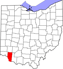
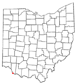 Location of Neville, Ohio | |
| Coordinates: 38°48′38″N 84°12′41″W / 38.81056°N 84.21139°WCoordinates: 38°48′38″N 84°12′41″W / 38.81056°N 84.21139°W | |
| Country | United States |
| State | Ohio |
| County | Clermont |
| Area[1] | |
| • Total | 0.46 sq mi (1.19 km2) |
| • Land | 0.40 sq mi (1.04 km2) |
| • Water | 0.06 sq mi (0.16 km2) |
| Elevation[2] | 499 ft (152 m) |
| Population (2010)[3] | |
| • Total | 100 |
| • Estimate (2012[4]) | 100 |
| • Density | 250.0/sq mi (96.5/km2) |
| Time zone | Eastern (EST) (UTC-5) |
| • Summer (DST) | EDT (UTC-4) |
| ZIP code | 45156 |
| Area code(s) | 513 |
| FIPS code | 39-53956[5] |
| GNIS feature ID | 1065102[2] |
Neville is a village in Clermont County, Ohio, United States, along the Ohio River. The population was 100 at the 2010 census.
Gallery
-
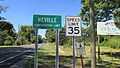
Neville corporation limit sign.
-
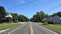
Looking east on US Highway 52 in Neville.
Geography
Neville is located at 38°48′38″N 84°12′41″W / 38.81056°N 84.21139°W (38.810504, -84.211345).[6]
According to the United States Census Bureau, the village has a total area of 0.46 square miles (1.19 km2), of which 0.40 square miles (1.04 km2) is land and 0.06 square miles (0.16 km2) is water.[1]
Demographics
2010 census
As of the census[3] of 2010, there were 100 people, 39 households, and 29 families residing in the village. The population density was 250.0 inhabitants per square mile (96.5/km2). There were 47 housing units at an average density of 117.5 per square mile (45.4/km2). The racial makeup of the village was 99.0% White and 1.0% Asian.
There were 39 households of which 28.2% had children under the age of 18 living with them, 59.0% were married couples living together, 7.7% had a female householder with no husband present, 7.7% had a male householder with no wife present, and 25.6% were non-families. 15.4% of all households were made up of individuals and 5.1% had someone living alone who was 65 years of age or older. The average household size was 2.56 and the average family size was 2.90.
The median age in the village was 43 years. 20% of residents were under the age of 18; 8% were between the ages of 18 and 24; 24% were from 25 to 44; 37% were from 45 to 64; and 11% were 65 years of age or older. The gender makeup of the village was 50.0% male and 50.0% female.
2000 census
As of the census[5] of 2000, there were 127 people, 47 households, and 38 families residing in the village. The population density was 304.5 people per square mile (116.7/km²). There were 56 housing units at an average density of 134.3 per square mile (51.5/km²). The racial makeup of the village was 99.21% White and 0.79% African American.
There were 47 households out of which 44.7% had children under the age of 18 living with them, 55.3% were married couples living together, 19.1% had a female householder with no husband present, and 19.1% were non-families. 17.0% of all households were made up of individuals and 8.5% had someone living alone who was 65 years of age or older. The average household size was 2.70 and the average family size was 3.03.
In the village the population was spread out with 32.3% under the age of 18, 3.9% from 18 to 24, 29.1% from 25 to 44, 25.2% from 45 to 64, and 9.4% who were 65 years of age or older. The median age was 35 years. For every 100 females there were 95.4 males. For every 100 females age 18 and over, there were 95.5 males.
The median income for a household in the village was $38,125, and the median income for a family was $38,438. Males had a median income of $32,500 versus $23,750 for females. The per capita income for the village was $14,001. There were 18.9% of families and 19.4% of the population living below the poverty line, including 22.9% of under eighteens and none of those over 64.
See also
- List of cities and towns along the Ohio River
References
- ↑ 1.0 1.1 "US Gazetteer files 2010". United States Census Bureau. Retrieved 2013-01-06.
- ↑ 2.0 2.1 "US Board on Geographic Names". United States Geological Survey. 2007-10-25. Retrieved 2008-01-31.
- ↑ 3.0 3.1 "American FactFinder". United States Census Bureau. Retrieved 2013-01-06.
- ↑ "Population Estimates". United States Census Bureau. Retrieved 2013-06-17.
- ↑ 5.0 5.1 "American FactFinder". United States Census Bureau. Retrieved 2008-01-31.
- ↑ "US Gazetteer files: 2010, 2000, and 1990". United States Census Bureau. 2011-02-12. Retrieved 2011-04-23.
| |||||||||||||||||||||||||||||||||