Nevada State Route 118
| ||||
|---|---|---|---|---|
| Wildes Road | ||||
|
Nevada State Route 118 highlighted in red. | ||||
| Route information | ||||
| Maintained by NDOT | ||||
| Length: | 3.480 mi[1] (5.601 km) | |||
| Existed: | December 31, 1991 – present | |||
| Major junctions | ||||
| Northwest end: |
| |||
| Southeast end: | Wildes Road within NAS Fallon | |||
| Highway system | ||||
| ||||

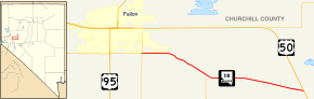
State Route 118 is a state highway in Nevada, USA. It runs from State Route 115 (Harrigan Road) in Fallon as Wildes Road east to Pasture Road. From there it continues along the northern edge of Naval Air Station Fallon ending at a point between Pasture Road and US 50.
References
Route map: Bing