Neuenhagen bei Berlin
| Neuenhagen bei Berlin | ||
|---|---|---|
|
Town hall | ||
| ||
 Neuenhagen bei Berlin | ||
Location of Neuenhagen bei Berlin within Märkisch-Oderland district  | ||
| Coordinates: 52°31′59″N 13°40′59″E / 52.53306°N 13.68306°ECoordinates: 52°31′59″N 13°40′59″E / 52.53306°N 13.68306°E | ||
| Country | Germany | |
| State | Brandenburg | |
| District | Märkisch-Oderland | |
| Government | ||
| • Mayor | Jürgen Henze (Ind.) | |
| Area | ||
| • Total | 19.58 km2 (7.56 sq mi) | |
| Population (2012-12-31)[1] | ||
| • Total | 17,007 | |
| • Density | 870/km2 (2,200/sq mi) | |
| Time zone | CET/CEST (UTC+1/+2) | |
| Postal codes | 15366 | |
| Dialling codes | 03342 | |
| Vehicle registration | MOL | |
| Website | www.neuenhagen-bei-berlin.de | |


Neuenhagen bei Berlin is a municipality in the district Märkisch-Oderland of Brandenburg, Germany. It is situated 19 km east of Berlin (centre) and was founded around 1230.
History
Neuenhagen bei Berlin was founded around 1230.
Geography
Neuenhagen bei Berlin is located next to Berlin in eastern Germany.
Demography
-
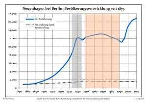
Development of Population since 1875 within the Current Boundaries (Blue Line: Population; Dotted Line: Comparison to Population Development of Brandenburg state; Grey Background: Time of Nazi rule; Red Background: Time of Communist rule)
-
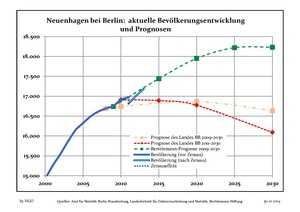
Recent Population Development (Blue Line) and Forecasts
Transport
The village is well connected to Berlin by the S-Bahn line S5 at the station of Neuenhagen.
Partnerships
Twin towns
-
 Świebodzin, Poland
 -
 Grünwald, Germany
References
- ↑ "Bevölkerung im Land Brandenburg nach amtsfreien Gemeinden, Ämtern und Gemeinden 31. Dezember 2012 (XLS-Datei; 83 KB) (Einwohnerzahlen auf Grundlage des Zensus 2011)". Amt für Statistik Berlin-Brandenburg (in German). 31 December 2012.
External links
![]() Media related to Neuenhagen bei Berlin at Wikimedia Commons
Media related to Neuenhagen bei Berlin at Wikimedia Commons