Nein
| Nein ניין نين | |
|---|---|
|
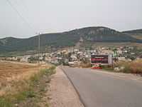
View of Nein from entrance to the village | |
 Nein | |
| Coordinates: 32°38′N 35°21′E / 32.633°N 35.350°ECoordinates: 32°38′N 35°21′E / 32.633°N 35.350°E | |
| Grid position | 183/226 PAL |
| Council | Bustan al-Marj |
| Population (2005) | 1,600 |
Nein (Arabic: نين, Na'in, lit. Charming, Hebrew: ניין, called in English Bibles Nain or Naim) is an Arab village in Israel that forms part of the Bustan al-Marj Regional Council in the Lower Galilee. Located 14 kilometers (8.7 mi) south of Nazareth, Nein covers a land area of approximately 1,000 dunums. Its total land area consisted of 3,737 dunums prior to 1962.[1] According to the Israeli Central Bureau of Statistics, Nein had a population 1,600 in 2005.[2] The city hall for the Bustan al-Marj Regional Council is located in Nein.[3]
Location
Nein lies a short distance from Mount Tabor.[4] A hill known in Arabic as Tell el-Ajul lay on the path that ran between Nein and nearby Indur, an Arab village destroyed in the 1948 Arab-Israeli war.[5] While Edward Robinson describes Nein as lying on the northern slope of a hill called, "the little Hermon," and it is described in biblical guidebooks as lying at the foot of the Hill of Moreh.[6]
Biblical associations

Edward Robinson and Eli Smith, who visited Palestine in the mid-19th century, identified Nein as, "the Nain of the New Testament," where, according to the Bible (Gospel of Luke 7:11-17), Jesus raised a young man from death and reunited him with his mother.[7]
According to Luke, this young man was the only son of an unnamed widow. When Jesus saw the dead son being carried out and the mourning widow, he felt compassion for her. He walked towards the bier or stretcher, touched it, stopped the funeral procession and told the man: "Young man, I say to you, arise!" The man came alive, sat up, and began to speak. The people who were standing around were all struck by the event, seen as a sign that 'a great prophet' had arisen among them, and the report of it spread widely across Judea and the surrounding region.
Nain is not mentioned in the other canonical gospels.
History
Nein is mentioned in the writing of Eusebius (c. 263–339) and Jerome (c. 347 – 420) as being situated near Endor (Indur).[7] Its identity as a biblical site was recognized by the Crusaders, who built a church there to commemorate the site of the miracle, a church rebuilt by the Fransciscans.[4][7]
Ottoman era
Nein has been visited by many travellers and pilgrims since. Robinson and Smith also note that Nein decreased in size over the ages, and was at their time of writing but a small hamlet, inhabited by only a few families.[7] At the end of the 19th century, Nein was described as a small village made of stone and adobe, with a small mosque, named Mukam Sidna Aisa, to the north.[8]
British Mandate era
In the 1922 census of Palestine conducted by the British authorities, Nain had a population of 157, all Muslims,[9] increasing in the 1931 census to 189, still all Muslim, in a total of 34 houses.[10]
In 1945 the population was 270 while the total land area was 4,687 dunams, according to an official land and population survey.[11] Of this, 87 dunams were for plantations and irrigable land, 3,602 for cereals,[12] while 31 dunams were classified as built-up areas.[13]
See also
References
- ↑ Welcome To Na'in
- ↑ Localities with populations of 1,000 or Above Israeli Central Bureau of Statistics, 2005
- ↑ Bustan El-Marj (Israel) Dov Gutterman, Flags of the World.
- ↑ 4.0 4.1 Carta, 1999, p. 26.
- ↑ van de Velde, 1858, p. 142.
- ↑ Robinson and Smith, 1856, p. 331.
- ↑ 7.0 7.1 7.2 7.3 Robinson and Smith, 1841, p. 226.
- ↑ Conder and Kitchener, SWP, 1882, II, p. 86
- ↑ Barron, 1923, Table XI, Sub-district of Nazareth, p. 38
- ↑ Mills, 1932, p. 75
- ↑ Government of Palestine, Department of Statistics. Village Statistics, April, 1945. Quoted in Hadawi, 1970, p. 62
- ↑ Government of Palestine, Department of Statistics. Village Statistics, April, 1945. Quoted in Hadawi, 1970, p. 110
- ↑ Government of Palestine, Department of Statistics. Village Statistics, April, 1945. Quoted in Hadawi, 1970, p. 160
Bibliography
| Wikimedia Commons has media related to Nein. |
- Barron, J. B., ed. (1923). Palestine: Report and General Abstracts of the Census of 1922. Government of Palestine.
- Carta (1999). The River Jordan: An Illustrated Guide from Bible Days to the Present (Illustrated ed.). Kregel Publications. ISBN 9780825423765.
- Conder, Claude Reignier; Kitchener, H. H. (1882). The Survey of Western Palestine: Memoirs of the Topography, Orography, Hydrography, and Archaeology 2. London: Committee of the Palestine Exploration Fund.
- Hadawi, Sami (1970). Village Statistics of 1945: A Classification of Land and Area ownership in Palestine. Palestine Liberation Organization Research Center.
- Mills, E., ed. (1932). Census of Palestine 1931. Population of Villages, Towns and Administrative Areas. Jerusalem: Government of Palestine.
- Palmer, E. H. (1881). The Survey of Western Palestine: Arabic and English Name Lists Collected During the Survey by Lieutenants Conder and Kitchener, R. E. Transliterated and Explained by E.H. Palmer. Committee of the Palestine Exploration Fund.
- Robinson, Edward; Smith, Eli (1856). Biblical Researches in Palestine and adjacent regions: A Journal of Travels in the years 1838 and 1852, 2nd edition 3. London: John Murray.
- Robinson, Edward; Smith, Eli (1856). Biblical researches in Palestine and the adjacent regions: a journal of travels in the years 1838 & 1852 by Edward Robinson, Eli Smith and others, Volume 2 (2nd ed.). J. Murray.
- van de Velde, Carel Willem Meredith (1858). Memoir to Accompany the Map of the Holy Land. Gotha: Justus Perthes.
External links
- Welcome To Na'in
- Survey of Western Palestine, Map 9: IAA, Wikimedia commons
| ||||||
| |||||||||||||||||||||

