Neemuch district
| Neemuch district नीमच जिला | |
|---|---|
| District of Madhya Pradesh | |
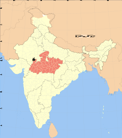 Location of Neemuch district in Madhya Pradesh | |
| Country | India |
| State | Madhya Pradesh |
| Administrative division | Ujjain |
| Headquarters | Neemuch |
| Tehsils | 1. Neemuch, 2. JIRAN and 3. Jawad 4 . Manasa |
| Government | |
| • Lok Sabha constituencies | Mandsaur (shared with Mandsaur district) |
| • Assembly seats | 1. Manasa, 2. Neemuch and 3. Jawad |
| Area | |
| • Total | 3,875 km2 (1,496 sq mi) |
| Population (2011) | |
| • Total | 825,958 |
| • Density | 210/km2 (550/sq mi) |
| Demographics | |
| • Literacy | 71.81 per cent |
| • Sex ratio | 959 |
| Major highways | NH 79 |
| Website | Official website |
Neemuch district (Hindi: नीमच जिला) is one of the 51 districts of Madhya Pradesh state in central India. The town of Neemuch is the administrative headquarters of the district.
Neemuch district is part of Ujjain Division and had approximately 700,000 inhabitants as of 2001.[1] Neemuch district is bordered by Rajasthan state on the west and north, and by Mandsaur district to the east and south.
History
This district was created on 30 June 1998 by separating Neemuch, Manasa and Jawad tehsils of the erstwhile Mandsaur district. During the British rule, the district headquarters Neemuch was a cantonment town, known as the North India Mounted Artillery and Cavalry Headquarters (NIMACH). It was later converted into the headquarters of the Crown's Representative Police Force in 1939.
Economy
It is one of the largest producers of opium in the world. It is also very large producer of oilseeds. Ghati is famous in Karadia Maharaj.
Demographics
According to the 2011 census Neemuch District has a population of 825,958,[2] roughly equal to the nation of Qatar[3] or the US state of South Dakota.[4] This gives it a ranking of 477th in India (out of a total of 640).[2] The district has a population density of 194 inhabitants per square kilometre (500/sq mi) .[2] Its population growth rate over the decade 2001-2011 was 13.76%.[2] Neemuch has a sex ratio of 959 females for every 1000 males,[2] and a literacy rate of 71.81%.[2]
Villages in Nimach tahsil
Admalya, Aghoriya, Akhepur, Akli, Akya, Amawalijagir, Amawalimahal, Amba, Amlikheda, Arnyaborana, Arnyachandel, Arnyachudawat, Arnyakumar, Arnyamangir, Aspura, Badoli, Baman Bardi, Bamanya, Bamora, Bamori, Banskheda, Banskhedi, Barkheda Hada, Barkheda Sondhiya, Barkhedagujar, Barukheda, Belari, Bhadaksanawda, Bhadbhadiya, Bhadwa Nimach|Bhadwa, Bhagwanpura, Bhanwrasa, Bhatkheda, Bhimakhedi, Bhimpura, Bholyawas, Bhopatpura, Bisalwasbamanya, Bisalwaskalan, Bisalwaskhurd, Bisalwassongira, Bordiyakalan, Bordiyakhurd, Borkhedikalan, Borkhedikhurd, Borkhedipandi, Chadoli, Chainpura, Chaldu, Champi, Changera, Chauthkheda, Cheeta Kheda, Chenpura, Chhachhkhedi, Chhayan, Dalawada, Dalpatpura, Dansiya, Daru, Dasani, Dhaba, Dhamaniya, Dhamaniyajagir, Dhaneriyakalan, Dhaneriyakhurd, Dholpura, Dipukhedi, Dowad, Dudarsi, Dulakheda, Dungalawada, Ghasundi, Ghasundijagir, Girdoda, Gopalpura, Gudla, Gulabkhedi, Gwaldeviya, Gwaltalab, Hameriya, Hanmantiyapawar, Hanmantyaraoji, Hanmantyavyas, Harnawada, Harwar, Hingoriya, Jagoli, Jaisingpura, Jamuniyakalan, Jamuniyakhurd, Jawasa, Jawi, Jetpura, Jhalri, Jhanjharwada, Jiran (NP), Kacholi, Kalikothadi, Kalyakhedi, Kanakheda, Kanawati, Kanpura, Karadiyamaharaja, Kasbi, Kelukheda, Kenpuriya, Keri, Khadawada, Khatyakhedi, Kheda, Khedadaru, Khermalya, Khetakheda Doriya, Khetakhedacharan, Kishanpura, Kothadi Istmurar, Kothadimagara, Kunchdod, Lakhmi, Lanchh, Lasudihada, Lasuditanwar, Lewada, Lolpura, Mahudiya, Maliya, Malkheda, Mangrol, Manpura, Matyakhedi, Melki, Melkimewad, Mundla, Narsinghpura, Nayankhedi, Neemuch (M) Newad, Nilkanthpura, Nipaniya, Nipaniya Abad, Palsoda, Parasali, Pawadakalan, Pawadakhurd, Pawati, Peerana, Peeth, Phophaliya, Pipalyabag, Pipalyacharan, Pipalyagujar, Pipalyahada, Pipalyajagir, Pipalyamircha, Pipalyanathawat, Pipalyavyas, Piplon, Rabadiya, Raisinghpura, Rajpuriya, Rampuriya, Ranpura, Ratadiya, Rawatkheda, Rayankheda, Rewalidewali, Sagrana, Sakrani, Sakranijagir, Samarkund, Sangariyakhedi, Sarwaniyabor, Sawalpura, Sawan, Sedariya, Semali Chandrawat, Semalimewad, Semarda, Sirkheda, Sokadi, Soniyana, Surjana, Talkheda, Thadoli, Thikariya, Tinakyakhedi, Ugran, Umaheda, Vishanya
References
- ↑ http://neemuch.nic.in/profile.htm
- ↑ 2.0 2.1 2.2 2.3 2.4 2.5 "District Census 2011". Census2011.co.in. 2011. Retrieved 2011-09-30.
- ↑ US Directorate of Intelligence. "Country Comparison:Population". Retrieved 2011-10-01.
Qatar 848,016 July 2011 est.
- ↑ "2010 Resident Population Data". U. S. Census Bureau. Retrieved 2011-09-30.
South Dakota 814,180
External links
- Neemuch District web site
- List of places in Neemuch
 |
Chittaurgarh district, Rajasthan (Western) | Bhilwara district, Rajasthan | Chittaurgarh district, Rajasthan (Eastern) | |
| |
||||
| ||||
| | ||||
| Pratapgarh district, Rajasthan | Mandsaur district |
| ||||||||||||||||||||||||||
| ||||||||||||||||||||||||||||||||||||||
Coordinates: 24°28′12″N 74°52′12″E / 24.47000°N 74.87000°E