Nectar Covered Bridge
| Nectar CB | |
|---|---|
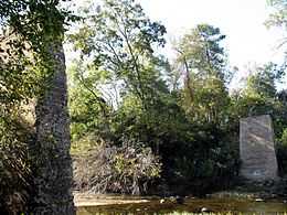
 Two stone piers remain where the Nectar Covered Bridge once stood. The bridge burned down in 1993. | |
| Coordinates | |
|
Nectar Covered Bridge | |
 | |
| Nearest city | Nectar, Alabama |
| Coordinates | 33°57′22.45″N 86°37′34.17″W / 33.9562361°N 86.6261583°WCoordinates: 33°57′22.45″N 86°37′34.17″W / 33.9562361°N 86.6261583°W |
| Area | 1.1 acres (0.4 ha) |
| Built | 1932 |
| Architectural style | Other, Four Span Town Truss |
| Governing body | Local |
| MPS | Blount County Covered Bridges TR |
| NRHP Reference # | 81000124[1] |
| Added to NRHP | August 20, 1981 |
| Carries | single lane motor traffic |
| Crosses | Locust Fork of the Black Warrior River |
| Locale | Nectar, Alabama |
| Maintained by | Blount County Commission |
| ID number | 01-05-04 (WGCB) |
| Characteristics | |
| Design | Town Lattice truss |
| Total length | 385 ft (117 m) |
| Load limit | 3 US tons (2.72 metric tons) |
| History | |
| Construction end | 1932 |
| Closed | June 13, 1993 by fire |
The Nectar Covered Bridge was a wood and metal combination style covered bridge which spanned the Locust Fork of the Black Warrior River in Blount County, Alabama, United States. It was located on Nectar Bridge Road off State Route 160, just east of the town of Nectar, about 14 miles (16 kilometers) northwest of Oneonta. Built in 1932, the bridge was at one time the seventh-longest covered bridge in the country. The bridge remained open to single lane motor traffic from its construction until it was burned by vandals on June 13, 1993.
History
Built in 1932, the 385-foot (117-meter) bridge was a Town Lattice truss construction over four spans. It was built by a crew led by Zelma C. Tidwell and uncle Forrest Tidwell over a wide section of the Locust Fork.[2] It was the second-longest covered bridge built in Blount County, to the latter constructed 432-foot (132-meter) Standridge Covered Bridge near Hayden, which burned down in 1967. At one time, the Nectar Covered Bridge was the seventh longest covered bridge in the country. The bridge was burned by vandals on June 13, 1993. It was maintained by the Blount County Commission and the Alabama Department of Transportation. The Nectar Covered Bridge was listed on the National Register of Historic Places on August 20, 1981.[1]
The bridge was once a community meeting place and a site for large baptism ceremonies.[3] A concrete bridge has since replaced the former covered bridge, but the old stone piers remain across the river south of the current crossing.
See also
References
- ↑ 1.0 1.1 "National Register Information System". National Register of Historic Places. National Park Service. 2010-07-09.
- ↑ Weaver, Warren; Ellen Mertins (July 7, 1981). "Nectar Covered Bridge". National Register of Historic Places Inventory-Nomination Form. National Park Service. Archived from the original on December 24, 2013. Retrieved December 24, 2013. See also: "Accompanying photos". Archived from the original on December 24, 2013. Retrieved December 24, 2013.
- ↑ "Bridges to the Past". Max Shores. Retrieved December 24, 2013.
Further reading
- Prince, A. G. (1981). Alabama's Covered Bridges: Past and Present (Revised ed.). Ensley: Best Printing Service.
- "01-05-04". Round Barns & Covered Bridges. Dale J. Travis. Retrieved December 24, 2013.
- Stith, Mark J. (1997). "Tunnels in Time". Southern Living. ISSN 0038-4305. Retrieved September 24, 2007.
- The Birmingham News (July 17, 1972) news article. Retrieved October 30, 2007.
- Alabama Department of Archives and History. Nectar CB: Credits. Retrieved October 30, 2007.
| |||||||||||||