Nayoro, Hokkaido
| Nayoro 名寄市 | ||
|---|---|---|
| City | ||
| ||
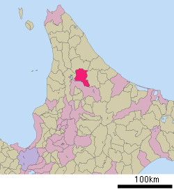 Location of Nayoro in Hokkaido (Kamikawa Subprefecture) | ||
 Nayoro Location in Japan | ||
| Coordinates: 44°21′21″N 142°27′48″E / 44.35583°N 142.46333°ECoordinates: 44°21′21″N 142°27′48″E / 44.35583°N 142.46333°E | ||
| Country | Japan | |
| Region | Hokkaido | |
| Prefecture | Hokkaido (Kamikawa Subprefecture) | |
| Government | ||
| • Mayor | Takeshi Kato | |
| Area | ||
| • Total | 535.23 km2 (206.65 sq mi) | |
| Population (March 2008) | ||
| • Total | 30,920 | |
| • Density | 58/km2 (150/sq mi) | |
| Time zone | Japan Standard Time (UTC+9) | |
| Symbols | ||
| - Tree | Japanese White Birch | |
| - Flower | Ōbana Enreisō (Trillium kamtschaticum) | |
| - Bird | Great Spotted Woodpecker | |
| Address |
1-1 Ōdōri Minami, Nayoro-shi, Hokkaido 096-8686 | |
| Phone number | 01654-3-2111 | |
| Website |
www | |


Nayoro (名寄市 Nayoro-shi, Ainu: Nay Oro meaning "in the middle of the valley") is a city located in Kamikawa Subprefecture, Hokkaido, Japan.
As of 2008, the city has an estimated population of 30,920 and a population density of 57.8 persons per km² (150 persons per sq. mi.). The total area is 535.23 km2 (206.65 sq mi).
The city was incorporated on April 1, 1956.
Overview
Nayoro is linked with Route 40 linking Wakkanai and southern Hokkaido as well as the Hokkaidō Expressway linking with the island capital of Sapporo.
Nayoro has schools, lyceums and gymnasia (secondary schools) along with a train station. Nayoro is bypassed to the west with the Nayoro Bypass (Route 40) serving two interchanges.
Nayoro is twinned with Lindsay, Ontario, Canada and Dolinsk, Russia.[1]
On March 27, 2006, the town of Fūren (from Kamikawa (Teshio) District) was merged into Nayoro.
Climate
| Climate data for Nayoro (1981–2010) | |||||||||||||
|---|---|---|---|---|---|---|---|---|---|---|---|---|---|
| Month | Jan | Feb | Mar | Apr | May | Jun | Jul | Aug | Sep | Oct | Nov | Dec | Year |
| Average high °C (°F) | −4.7 (23.5) |
−3.3 (26.1) |
1.4 (34.5) |
9.2 (48.6) |
17.2 (63) |
22.2 (72) |
25.5 (77.9) |
25.9 (78.6) |
21.1 (70) |
14.1 (57.4) |
5.1 (41.2) |
−1.8 (28.8) |
10.99 (51.8) |
| Daily mean °C (°F) | −9.4 (15.1) |
−9 (16) |
−3.6 (25.5) |
3.8 (38.8) |
10.4 (50.7) |
15.4 (59.7) |
19.2 (66.6) |
20.1 (68.2) |
14.8 (58.6) |
8.1 (46.6) |
1.2 (34.2) |
−5.4 (22.3) |
5.47 (41.86) |
| Average low °C (°F) | −15.8 (3.6) |
−16.2 (2.8) |
−9.8 (14.4) |
−1.7 (28.9) |
3.6 (38.5) |
9.2 (48.6) |
13.9 (57) |
15.2 (59.4) |
9.4 (48.9) |
2.9 (37.2) |
−2.7 (27.1) |
−10.3 (13.5) |
−0.19 (31.66) |
| Average precipitation mm (inches) | 54.6 (2.15) |
41.2 (1.622) |
45.3 (1.783) |
45.7 (1.799) |
57.5 (2.264) |
58.6 (2.307) |
112.9 (4.445) |
121.9 (4.799) |
131.6 (5.181) |
117.0 (4.606) |
112.1 (4.413) |
79.6 (3.134) |
978 (38.503) |
| Average snowfall cm (inches) | 208 (81.9) |
162 (63.8) |
140 (55.1) |
36 (14.2) |
0 (0) |
0 (0) |
0 (0) |
0 (0) |
0 (0) |
3 (1.2) |
112 (44.1) |
229 (90.2) |
890 (350.5) |
| Mean monthly sunshine hours | 64.0 | 90.5 | 133.6 | 157.5 | 186.5 | 168.3 | 145.4 | 141.9 | 139.1 | 109.9 | 52.1 | 42.4 | 1,431.2 |
| Source: Japan Meteorological Agency | |||||||||||||
References
External links
![]() Media related to Nayoro, Hokkaidō at Wikimedia Commons
Media related to Nayoro, Hokkaidō at Wikimedia Commons
- Official website (Japanese)
| ||||||||||||||||||||||||||