Navi Mumbai
| Navi Mumbai नवी मुंबई | |
|---|---|
| Planned Business Township of Mumbai | |
 Navi Mumbai | |
| Coordinates: 19°01′N 73°01′E / 19.02°N 73.02°ECoordinates: 19°01′N 73°01′E / 19.02°N 73.02°E | |
| Country |
|
| State | Maharashtra |
| District | Thane |
| Metro | Mumbai |
| Population | 1,119,477 |
| Vehicle registration | MH-43 |
| Vidhan Sabha constituency |
Airoli Belapur Panvel |
Navi Mumbai is a planned township of Mumbai on the west coast of the Indian state of Maharashtra. It was developed in 1972 as a new urban township of Mumbai. The population of Navi Mumbai has reached 1,119,477[1] as per the 2011 provisional census.
History
Navi Mumbai, located in the eastern trans harbour of Mumbai, Maharashtra, is one of the world's largest planned townships . Since independence, the decision to build a new city on the mainland across the harbour was for a specific purpose: to decongest Mumbai, an island city whose physical expansion had a limit. It was also earmarked as an alternate haven for the multitudes that thronged to Mumbai from all over India. This decision required the state government to exercise the matching, politically speaking, hard option to relocate its seat of governance along with all its important offices to this new city, and completely stop the backbay reclamation project in the island city. It did nothing of the sort. It continued with the reclamation and put brakes on the efforts of CIDCO (such as the shifting of wholesale markets).
Planned City
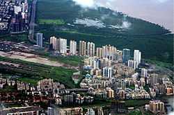
The planning of Navi Mumbai could begin, in the right earnest, only by 1971, and involved leading architects and urban planner like, Charles Correa (Chief Architect), Shirish Patel, Pravina Mehta[2] and R. K. Jha (Chief Planner),[3] South Navi Mumbai is being developed rapidly with its class infrastructure and modern nodes of Kharghar, Kamothe, New Panvel and Kalamboli.
CIDCO Development


The City and Industrial Development Corporation (CIDCO) was formed on 17 March 1971, under the Indian Companies Act, 1956. The area covered 150 kilometres (93 mi) of the total 720 kilometres (450 mi) of the Konkan coast. Privately owned land conisisting of 86 villages covering 15,954 hectares (39,420 acres) within the present limits of Navi Mumbai and further villages measuring an additional 2,870 hectares (7,100 acres) were acquired by the government of Maharashtra. The major part of Navi Mumbai covers southern part of Thane Taluka ( From Thane District)and part of Panvel and Uran taluka (From Raigad District).
CIDCO carved out 14 nodes small townships with a view towards facilitating comprehensive development. These nodes are named Airoli, Ghansoli, Kopar Khairane, Vashi, Sanpada, Nerul, CBD Belapur, Kharghar, Kamothe, New Panvel, Kalamboli, Ulwe, Dronagiri, Taloja.
CIDCO planned and constructed all the railway stations in Navi Mumbai and developed nearby areas commercially.

In 1973, the Vashi bridge was opened to the public for residents of Vashi, CBD Belapur and Nerul. The Sion-Panvel Expressway was built to reduce the time taken to travel from Sion to Panvel. Initially there was not much response to the new city. Major changes took place only after 1990, with the commissioning of a wholesale agricultural produce market at Vashi and the construction of a commuter railway line from Mankhurd to Vashi in May 1992. These developments caused a sudden growth in economic activities and population in Navi Mumbai.
Recent Developments
By the end of the 1990s, the planning authority of Navi Mumbai initiated private participation in the developmental activity of Navi Mumbai.
A new railway link between Nerul and Uran is under construction and the portion of this line from Seawood to Ulwe is at an advanced stage of construction.[4] Kharghar and Panvel are experiencing major infrastructural developments due to their proximity to the proposed Navi Mumbai International Airport. Also a latest development known as 'One Time Planning' with an estimated budget of 12,821 crores is underway to transform Navi Mumbai on the lines of the Mega Cities of the world.
Administration
CIDCO
When Navi Mumbai was created in the 1970s, CIDCO was the only authority that looked after the development and maintenance of the city. CIDCO prepared a developmental plan for Navi Mumbai covering 95 villages

For the first ten years of the project CIDCO acted as the planning and administrative body, and as the developer and builder for the project. Taxes on property, land, commercial and water were payable to CIDCO. The 14 nodes which CIDCO created were named Airoli, Ghansoli, Kopar Khairane, Vashi, Sanpada, Nerul, CBD Belapur, Kharghar, Kamothe, New Panvel, Kalamboli, Ulwe, Pushpak and Dronagiri. Each of the nodes is divided into smaller groups called sectors.
Initially only Vashi, Nerul and CBD Belapur were developed by CIDCO with housing, schools and community centre roads. But after the arrival of the harbour railway line extension in the 1990s, there was an increase in population. CIDCO shifted its development plan to nodes like Kharghar, Kamothe, New Panvel, and Kopar Khairane. In its new development plan, CIDCO land was allocated to builders for housing. CIDCO only provided basic infrastructure like roads, water and electricity, these nodes were developed mostly by private builders according to the CIDCO plan.
NMMC

On 17 December 1991, Navi Mumbai Municipal Corporation (NMMC) was constituted by the state government for maintaining some of the developed nodes of Navi Mumbai.
Local self-government started on 1 January 1992. NMMC was handed nine of the 14 nodes of the Navi Mumbai project area for its jurisdiction. However, CIDCO, as a planning authority, has rights on the open plots in these five nodes.
The nine nodes maintained by NMMC are CBD Belapur, Nerul, Vashi, Turbhe, Kopar khairane, Ghansoli, Airoli, Digha, and Sanpada as of 1 January 1998, with the physical and social infrastructure already in place.
With annual budget exceeding Navi Mumbai Municipal Corporation, it is rated amongst the richest corporations in Maharashtra.
The municipal corporation is headed by a municipal commissioner and an elected mayor. Currently, the Mayor of Navi Mumbai is Nationalist Congress Party (NCP) member Sagar Naik. There are 89 electoral wards in Navi Mumbai.[5] A corporator is elected in each of the wards.
The newly developed nodes of Navi Mumbai on the south side like Kharghar, Kamothe, New Panvel and Kalamboli are still maintained by CIDCO. These nodes, which are all beyond CBD Belapur, come under the Raigad district and are under the maintenance of CIDCO.
Demographics
As per provisional reports of Census India, population of Navi Mumbai in 2011 is 1,119,477; of which male and female are 611,501 and 507,976 respectively. Although Navi Mumbai city has population of 1,119,477; its urban / metropolitan population is 18,414,288 of which 9,894,088 are males and 8,520,200 are females.
In education section, total literates in Navi Mumbai city are 911,542 of which 519,257 are males while 392,285 are females. Average literacy rate of Navi Mumbai city is 91.57 percent of which male and female literacy was 95.05 and 87.33 percent. The sex ratio of Navi Mumbai city is 831 per 1000 males. Child sex ratio of girls is 901 per 1000 boys.
Migration to Navi Mumbai[1]
| Last place of Residence | 2010 survey |
|---|---|
| Island city (%) | 54.6 |
| Western Suburbs (%) | 15.9 |
| Eastern Suburbs (%) | 5.9 |
| Other districts of Maharashtra (%) | 7.1 |
| Outside Maharashtra (%) | 0.7 |
The above table presents that 30% of households shifted from Island city, 5% from western suburbs around 6% each from Eastern suburbs, 2% from other Metro Region. The survey report- 2005 also shows 9% from villages of Navi Mumbai, 7% from other district of Maharashtra state and 6% from other parts of the country, while 30% stay in Nodes of Navi Mumbai.
Transport


Within each node, the auto rickshaw is the preferred mode of transportation. Taxis operating from designated taxi stands provide the means to travel further to destinations. Taxis charge a fixed rate approved by the R.T.O.
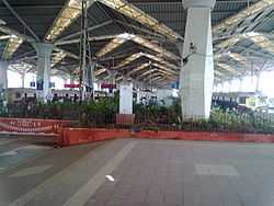
The Mumbai suburban railway network covers most of the populated region of the city. The most important suburban stations are Vashi, Nerul, Belapur & Panvel. The stations are planned as major railway junctions. Panvel is the only mainline station and also the busiest railway station of Navi Mumbai. All outstation trains halt here for time periods varying from 5 to 20 minutes. It is an important junction, railway lines come and meet here and it is connected to almost all parts of India. A new broad gauge line is functional between Karjat & Panvel and currently plies three express trains.
Brihanmumbai Electric Supply and Transport (BEST) & Navi Mumbai Municipal Transport (NMMT) buses travels all over Mumbai, Navi Mumbai, Thane, Kalyan-Dombivli-Badlapur, Panvel-Khopoli, Uran, Bhayandar etc. NMMT AC Volvo and BEST AC Kinglong buses are available from Mumbai to Navi Mumbai and vice versa.
The 10 km long Palm Beach Road of six lane connects Vashi to CBD Belapur running parallel to the creek. It is a twin of the Marine Drive.
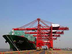
Navi Mumbai boasts the most advanced port in India, Jawaharlal Nehru port at Nhava Sheva near Uran. It is well connected with road, and handles approximately 65% of India's container traffic.
Navi Mumbai is located just 30 km away from Chatrapati Shivaji International Airport.
International Airport
The Navi Mumbai International Airport will be built in the Panvel area, It will be built through Public Private Partnership (PPP), with private sector partners having 74% equity and the Airports Authority of India (AAI) and Government of Maharashtra (through CIDCO) each holding 13%.
The International Civil Aviation Organization (ICAO) has already given techno-feasibility clearance to the airport. The central government provided cabinet approval for the construction on 31 May 2007. Specialised consultants were appointed and the global tendering process is underway. The government authorities are still planning the land acquisition.
Infrastructure
Basic infrastructure worth ![]() 40 billion (US$630 million) is already in place.[6] The city boasts a reliable supply of electricity from various sources, and excellent motoring conditions, with numerous flyovers, broad roads, and parking lots. The main problem which the residents face is poor connectivity with Mumbai, with only two road links between the two cities and a single rail line. A hovercraft service from Vashi to Colaba and the CBD to Colaba did not succeed due to the high cost of tickets and maintenance. Cidco is planning to relaunch its hovercraft service from Vashi, Belapur, Nerul, and Airoli to Gateway of India.
40 billion (US$630 million) is already in place.[6] The city boasts a reliable supply of electricity from various sources, and excellent motoring conditions, with numerous flyovers, broad roads, and parking lots. The main problem which the residents face is poor connectivity with Mumbai, with only two road links between the two cities and a single rail line. A hovercraft service from Vashi to Colaba and the CBD to Colaba did not succeed due to the high cost of tickets and maintenance. Cidco is planning to relaunch its hovercraft service from Vashi, Belapur, Nerul, and Airoli to Gateway of India.
Services
There are adequate utility services, banks, restaurants, malls, multiplexes and other shops in Navi Mumbai. Vashi boasts several shopping malls such as Center One, Palm Beach Galleria, Citi Center, Raghuleela Mall and Inorbit Mall. Palm Beach Road, Nerul, and Kharghar are also witnessing the construction of malls like lil world and glomax and multiplexes. Throughout Navi Mumbai supermarkets and malls like Apna Bazaar, More, Spencer's, Reliance Fresh, Spinach and Fairprice cater to the shopping needs of the residents. DMart has launched five hypermalls in Navi Mumbai.
Leading banks such as the State Bank of India, Union Bank, Saraswat Bank, Bank of Baroda, Bank of Maharashtra, Bank of Hyderabad, Citibank India, ICICI Bank, and HDFC Bank have their branches and ATMs around Navi Mumbai. The Reserve Bank of India has served the people of Navi Mumbai since 2001.
Navi Mumbai has some three- and five-star hotels.
Commerce


The Navi Mumbai Special Economic Zone (SEZ) located in the nodes of Dronagiri and Kalamboli are planned to provide commercial growth and employment to the city. Positioned en route the proposed Navi Mumbai Airport, this megaproject has attracted investments of close to 40,000 crores. Navi Mumbai is a new hub for newly incorporated companies & start ups to establish their base in Mumbai.[7] As per the list of newly incorporated companies in Navi Mumbai around 500 new & startups companies were registered in and around the region every month
Sports

Cricket is the prevalent sport in the city. Navi Mumbai has its own International Cricket Ground in Nerul called the DY Patil Stadium which hosted 3 IPL T-20 matches and the IPL T-20 Cricket Final. It is said that this stadium is one of the best in India. It is also the home ground for the football tournament Indian Super League team Mumbai City FC.
Navi Mumbai has an Olympic-size swimming pool at Nerul. CIDCO has proposed two 18-hole golf course academies at Nerul and Kharghar. There are plans to have sports facilities in the proposed 80 hectare central park being developed in Kharghar. The CIDCO has also constructed an 11-hole golf course at Kharghar.
References
- ↑ 1.0 1.1 "Cidco:Population".
- ↑ "Master class with Charles Correa". Mumbai Mirror. Jun 9, 2013. Retrieved 2 July 2013.
- ↑ Mehta, H.: Man who built Navi Mumbai is in Gujarat The Times of India 21 February 2010. Accessed 27 January 2014.
- ↑ The Economic Times (November 20, 2012). "Ulwe in Mumbai emerges as top destination for realty investment" (News). Indiatimes.com. Retrieved September 26, 2013.
- ↑ Navi Mumbai Municipal Corporation > Corporation > Elected Members Accessed 14 January 2014.
- ↑ Maharashtra IT parks The Recommended New Address For 21st Century Corporate India
- ↑
External links
| Wikimedia Commons has media related to Navi Mumbai. |
 Navi Mumbai travel guide from Wikivoyage
- Kharghar Navi Mumbai Shop Details
- Navi Mumbai Municipal Corporation Accessed 11 October 2012.
- Navi Mumbai Special Economic Zone
- CIDCO – City and Industrial Development Corporation Accessed 29 June 2013.