Nauen
| Nauen | ||
|---|---|---|
|
Saint Peter and Paul Church | ||
| ||
 Nauen | ||
Location of Nauen within Havelland district  | ||
| Coordinates: 52°36′00″N 12°52′59″E / 52.60000°N 12.88306°ECoordinates: 52°36′00″N 12°52′59″E / 52.60000°N 12.88306°E | ||
| Country | Germany | |
| State | Brandenburg | |
| District | Havelland | |
| Government | ||
| • Mayor | Detlef Fleischmann (SPD) | |
| Area | ||
| • Total | 266.78 km2 (103.00 sq mi) | |
| Population (2012-12-31)[1] | ||
| • Total | 16,491 | |
| • Density | 62/km2 (160/sq mi) | |
| Time zone | CET/CEST (UTC+1/+2) | |
| Postal codes | 14641 | |
| Dialling codes | 03321 | |
| Vehicle registration | HVL (alt NAU) | |
| Website | www.nauen.de | |


Nauen is a town in the Havelland district, in Brandenburg, Germany. It is situated 38 km west of Berlin (centre) and 26 km northwest of Potsdam.
History


Nauen is well known for the location of a transmission site. It was used from 1906 to 1945 for VLF and shortwave. After 1945 the installations were dismantled, but after 1955 the GDR started building up a shortwave transmission center at Nauen. Since 1997 four turnable shortwave transmission aerials have been sited there.

Demography
-
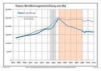
Population trends since 1875 within the current boundaries (blue line: population; dotted line: comparison to population trends in the state of Brandenburg; grey background: time of Nazi rule; red background: time of Communist rule)
-
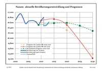
Recent population development (blue line) and forecasts
|
|
|
|
Detailed data sources are to be found in the Wikimedia Commons.[3]
See also
References
- ↑ "Bevölkerung im Land Brandenburg nach amtsfreien Gemeinden, Ämtern und Gemeinden 31. Dezember 2012 (XLS-Datei; 83 KB) (Einwohnerzahlen auf Grundlage des Zensus 2011)". Amt für Statistik Berlin-Brandenburg (in German). 31 December 2012.
- ↑ Boundaries as of 2013
- ↑ Population Projection Brandenburg at Wikimedia Commons
External links
![]() Media related to Nauen at Wikimedia Commons
Media related to Nauen at Wikimedia Commons
| ||||||||