National Weather Service Norman, Oklahoma
 | |
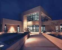
 View of the National Weather Center, the current location of NWS Norman. | |
| Agency overview | |
|---|---|
| Formed | November 1, 1890 |
| Preceding agencies |
National Weather Service Oklahoma City, Oklahoma Weather Bureau Oklahoma City, Oklahoma |
| Type | Meteorological |
| Jurisdiction | Federal Government of the United States |
| Headquarters |
120 David L Boren Blvd, Norman, Oklahoma 73072 35°10′55″N 97°26′24″W / 35.182°N 97.440°WCoordinates: 35°10′55″N 97°26′24″W / 35.182°N 97.440°W |
| Employees | 25 |
| Agency executives |
David Andra, Meteorologist in Charge Rick Smith, Warning Coordination Meteorologist |
| Parent agency | National Weather Service |
| Website |
www |
National Weather Service - Norman, Oklahoma (OUN), is the local National Weather Service Weather Forecast Office (WFO) for central and most of western Oklahoma, with the exception of the panhandle. The office in Norman currently operates a WSR-88D (NEXRAD) radar system. OUN has received widespread recognition from local media, especially concerning certain weather conditions that are or are forecast to occur.[1][2] It has also received attention from national media, and was even recognized and visited by United States President Barack Obama.[3][4][5] The office manages three different local Doppler weather radars: one in Oklahoma City (TLX) in Central Oklahoma, one in Southwestern Oklahoma in Frederick (FDR), and one in northern Oklahoma at Vance Air Force Base (VNX).[6] It is located on campus of the University of Oklahoma in the National Weather Center, where it acts as one of the NOAA Weather Partners, a group of close-together weather-related agencies of the National Oceanic and Atmospheric Administration.[7] Currently, the Meteorologist In Charge is David Andra.[6]

History
Location
On November 1, 1890, a Weather Bureau office was created in Central Oklahoma, beginning operation in Oklahoma City at the Overholser Opera House, in the southeast corner of the intersection of Robinson and Grand. A long time after the Weather Bureau had changed its location, the theater it had been housed in was demolished in 1964, and today, the Cox Convention Center now stands there. After leaving the Opera House, the office changed location again, and officially began operation at its new location, the Culbertson Building at the southeast corner of Broadway and Grand, beginning operation on July 1, 1902. It was closed only a few years later on January 16, 1906, the reason being that a new weather observatory was being constructed at 1923 Classen Boulevard in Oklahoma City, where the office relocated soon after.[6] On April 2, 1932, a new Weather Bureau office opened at Will Rogers Airport. The office then began a slow transition from the weather observatory to the office at the airport. Eventually, an actual building was constructed at the airport to house just the Weather Bureau office, and the office moved there on October 22, 1965. Shortly after, the U.S. Weather Bureau was renamed the National Weather Service (NWS). On January 27, 1987, the National Weather Service office relocated to a building that had been constructed at Max Westheimer Airport in Norman, Oklahoma, specifically for the use of the NWS office. Later on, the Storm Prediction Center (SPC) relocated there from its previous location in Kansas City, and the National Severe Storms Laboratory (NSSL) had also been located there. On August 7, 2006, the National Weather Service office, the SPC, and the NSSL began to move to a new building on the University of Oklahoma's south Research Campus, known as the National Weather Center, where it is still located today.[6]
Weather
The forecast office was responsible for local forecasting during many severe weather events, as well as winter weather events. The County Warning Area has been the site of significant tornado outbreaks and other significant weather events which were covered by the Norman office.

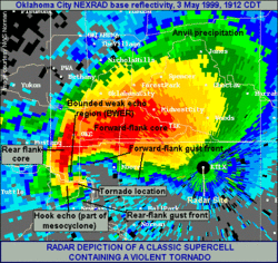
In early-May 1999, a major tornado outbreak occurred in the United States, with some of the greatest impacts focused over much of Oklahoma, especially locations in the Norman County Warning Area on May 3. The ninth tornado was of the greatest significance, and it was the first tornado known to surpass $1 billion USD in costs.[8][9][9] This tornado moved over much of the Oklahoma City metropolitan area, and as the tornado progressed over the Bridge Creek area near southwestern OKC, a mobile Doppler on Wheels radar remotely sensed winds above the ground within the tornado with the widely accepted 301 ± 20 mph (484 ± 32 km/h), among the highest winds known to have ever been observed on or near the Earth's surface.[10][11][12][13] As the tornado continued to move across Newcastle toward Moore and Oklahoma City, at 6:57 PM, the Norman forecast office issued a Severe Weather Statement containing the first Tornado Emergency for Moore and Oklahoma City as a way of sending out the message that the present situation was more dangerous than normal.[14]
Websites
The National Weather Service forecast office in Norman has created a multitude of websites that are open to the public. These include a main page for the Norman forecast area, a Facebook page, and a Twitter page.[6][15][16]
Official website
The Norman's website contains a variety of information, including, but not limited to an array of forecast conditions, information about past and present events involving the Norman forecast area, and, generally, a text-based "Hazardous Weather Outlook."
Local map
One of the Norman office's available features on its website is a localized forecast map. This map, accessible from the website's front page, contains a map of the Norman forecast area, with a selection of tabs that vary depending on the forecast conditions over the next few days, although it generally will have a map of current conditions and temperatures, and a diagram depicting the seven-day forecast. These maps exist on the sites of many other offices in the SRH area as well.[17]
Observation data
The Norman website contains a list many different weather observation locations, and by using the connected links, weather information collected in the previous three days can be analyzed. New information is generally added to each of these pages at constant intervals, although the data obtained has differing collection rates between each selected location.[18]
Social media
The Norman WFO like many of the other national forecast offices has a large social media presence in the hopes of better communication with the public. The Norman office posts weather-related information that they deem to be significant, such as warnings, forecasts, and other updates relevant to the Norman forecast area. This information is posted to Facebook, Twitter, and YouTube.[15] It also, on occasion, shares important or otherwise relevant links to other sites, as part of an attempt to keep people weather-aware.[15] The Norman office's Twitter page, as of August 2, 2013, had the highest number of followers of any NWS WFO Twitter pages, with 26,866 followers, a significant lead over the second most popular Twitter page, that of the Boston WFO, with 7,625 followers.[19]
NOAA Weather Radio

NOAA Weather Radio is a service provided by the National Oceanic and Atmospheric Administration (NOAA). The service transmits information concerning warnings and forecasts provided by the local NWS office. It works in cooperation with the Federal Communications Commission, transmitting information provided by its Emergency Alert System. The Weather Forecast Office in Norman sends information through the use of 12 transmitters across Oklahoma and one transmitter in western north Texas.[20]
| Radio Transmitter | Name | Frequency (MHz) | Start Date | Map |
|---|---|---|---|---|
| Altus, OK | WWG-97 | 162.425 | June 17, 1998 |  |
| Ardmore, OK | KXI-57 | 162.525 | September 6, 1999 |  |
| Atoka, OK | KWN-49 | 162.500 | 2003 |  |
| Chickasha, OK | KJY-94 | 162.450 | January 7, 2007 |  |
| Clinton, OK | WXK-87 | 162.525 | January 6, 1979 |  |
| Enid, OK | WXL-48 | 162.475 | June 13, 1979 |  |
| Lawton, OK | WXK-86 | 162.550 | December 15, 1978 |  |
| Oklahoma City, OK | WXK-85 | 162.400 | September 18, 1978 |  |
| Ponca City, OK | WWF-42 | 162.450 | September 30, 1994 |  |
| Stillwater, OK | WNG-654 | 162.500 | July 13, 2004 |  |
| Wewoka, OK | KJY-95 | 162.550 | November 29, 2006 |  |
| Wichita Falls, TX | WXK-31 | 162.475 | May 2, 1978 |  |
| Woodward, OK | WWG-46 | 162.500 | September 25, 1997 |  |
See also
- National Weather Service
- National Weather Center
- University of Oklahoma
- Storm Prediction Center
- National Severe Storms Laboratory
References
- ↑ Bryan Painter (2013-12-05). "Your Oklahoma City metro weather from the National Weather Service, Norman". Retrieved 2014-01-04.
- ↑ Bryan Painter (2013-12-20). "More on the Ice Storm Warnings, National Weather Service, Norman". Retrieved 2014-01-04.
- ↑ NOAA (2013-05-28). "President meets with NWS forecasters following devastating Oklahoma tornado". Retrieved 2014-01-04.
- ↑ KOCO 5 News (2013-05-28). "Norman's National Weather Service staff meet President Obama". Retrieved 2014-01-04.
- ↑ Andrea Thompson (2013-05-28). "Pres. Obama Thanks Tornado Forecasters in Oklahoma". Retrieved 2014-01-04.
- ↑ 6.0 6.1 6.2 6.3 6.4 OUN Webmaster. "National Weather Service Weather Forecast Office Norman, Oklahoma". Retrieved 2013-09-24.
- ↑ National Weather Center. "National Weather Center Partners". Retrieved 2013-09-24.
- ↑ Robert Henson (2000). "Unsettled Skies: Billion-Dollar Twister". Scientific American, Inc. Retrieved April 30, 2014.
- ↑ 9.0 9.1 OUN Webmaster (April 28, 2014). "The Great Plains Tornado Outbreak of May 3-4, 1999". National Oceanic and Atmospheric Administration. Retrieved April 30, 2014.
- ↑ "Doppler On Wheels". Center for Severe Weather Research. 2014. Retrieved February 10, 2014.
- ↑ Sizes, Inc. (2000). "Tornado Speeds May 3, 1999". Retrieved 2013-09-24.
- ↑ Jack Williams. "Doppler radar measures 318 mph wind in tornado". Retrieved 2013-10-14.
- ↑ David Whitehouse (1999-05-13). "US tornado breaks records". BBC News Online. Retrieved 2013-10-14.
- ↑ Bill Murray (May 2, 2008). "First Ever Tornado Emergency Message". WBMA-LD. Retrieved April 30, 2014.
- ↑ 15.0 15.1 15.2 NWS Norman, OK. "NWS Norman Facebook". Retrieved 2013-10-02.
- ↑ NWS Norman, OK. "NWS Norman Twitter". Retrieved 2013-10-02.
- ↑ SRH Webmaster. "SRH Main Page". Retrieved 2013-10-03.
- ↑ OUN Webmaster. "Norman Forecast Area Current Weather Conditions". Retrieved 2013-10-03.
- ↑ Louis W. Uccellini (March 2014). "May 2013 Oklahoma Tornadoes and Flash Flooding". Department of Commerce. Retrieved 2014-03-23.
- ↑ OUN Webmaster (2010-11-02). "National Weather Service Weather Radio Norman". Retrieved 2013-10-15.
External links
- Official NWS Norman Website
- NWS Norman Facebook Page
- NWS Norman Twitter Page
- NWS Youtube Channel
- NOAA Weather Partners
| ||||||||||||||||||||||||||