National Register of Historic Places listings in western Puerto Rico
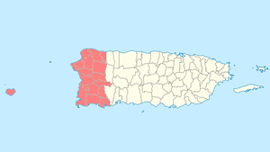
This is a list of properties and districts in the Porta del Sol municipalities of Puerto Rico that are listed on the National Register of Historic Places. It includes places along the western coast, and on islands, and in the peaks and on the western slope of Puerto Rico's Cordillera Central.
The area covered spans from the 17 municipalities in the Porta del Sol area: Quebradillas, Isabela, San Sebastián, Moca, Aguadilla, Aguada, Rincón, Añasco, Mayagüez, Las Marías, Maricao, Hormigueros, San Germán, Sábana Grande, Guánica, Lajas and Cabo Rojo.. All NRHP-listed places west, on the coasts, islands, slopes, and in the peaks of the Cordillera are included.
Names of places given are as they appear in the National Register, reflecting name as given in NRHP application at the date of listing. Note, the National Register name system does not accommodate Spanish á, ñ and other letters.
See also:
- National Register of Historic Places listings in southern Puerto Rico
- National Register of Historic Places listings in northern Puerto Rico
- National Register of Historic Places listings in eastern Puerto Rico
- National Register of Historic Places listings in central Puerto Rico
- National Register of Historic Places listings in metropolitan San Juan, Puerto Rico
Western municipalities
Aguada
| [1] | Name on the Register | Image | Date listed[2] | Location | City or town | Description |
|---|---|---|---|---|---|---|
| 1 | Puente de Coloso | Upload image | (#10001102) |
State Road No. 418, km .5 Coordinates missing |
Guanabano | Historic Bridges of Puerto Rico MPS |
Aguadilla
Former listings
| [1] | Name on the Register | Image | Date listed | Date removed | Location | City or town | Summary |
|---|---|---|---|---|---|---|---|
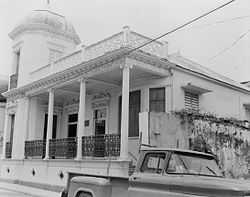
| 1 | Silva-Benejan House | Upload image | (#87000725) | 15 Munoz Rivera Street |
Aguadilla |
Añasco
| [1] | Name on the Register | Image | Date listed[2] | Location | City or town | Description |
|---|---|---|---|---|---|---|
| 1 | Puente de Anasco | 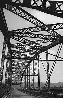 |
(#11000018) |
PR 2 at kilometer 146.1 18°16′21″N 67°09′42″W / 18.272599°N 67.161676°W |
Añasco/Mayagüez border |
Cabo Rojo
| [1] | Name on the Register | Image | Date listed[2] | Location | City or town | Description |
|---|---|---|---|---|---|---|
| 1 | Punta Ostiones | Upload image | (#04000908) |
Vic. of Cabo Rojo Coordinates missing |
Cabo Rojo | |
| 2 | Faro de los Morrillos de Cabo Rojo | 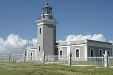 |
(#81000685) |
17°56′01″N 67°11′32″W / 17.9336°N 67.1922°W |
Cabo Rojo |
Guánica
| [1] | Name on the Register | Image | Date listed[2] | Location | City or town | Description |
|---|---|---|---|---|---|---|
| 1 | Faro de Guanica | 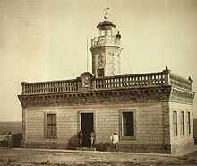 |
(#77001549) |
Vic. of Guanica 17°57′12″N 66°54′12″W / 17.953333°N 66.903333°W |
Guanica | Lighthouse from 1893 |
| 2 | Hacienda Santa Rita | 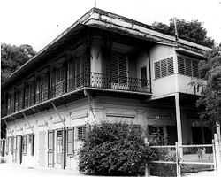 |
(#84003147) |
Vic. of Guanica 18°00′30″N 66°53′01″W / 18.008333°N 66.883611°W |
Guanica | |
| 3 | Yauco Battle Site | 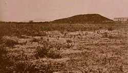 |
(#00001383) |
Near Lomas de Seboruco in Carenero, Guanica Coordinates missing |
Guanica | Site of the Battle of Yauco in 1898, in the Spanish–American War. See Puerto Rico Campaign. The Battle field was located at the time in Yauco, however the site became part of modern day Guanica after the founding of the municipality. |
Hormigueros
| [1] | Name on the Register | Image | Date listed[2] | Location | City or town | Description |
|---|---|---|---|---|---|---|
| 1 | Santuario de la Monserrate de Hormigueros and Casa de Peregrinos | 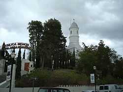 |
(#75002134) |
Calle Peregrinos No. 1 on Insular Rte. 344 18°08′35″N 67°07′39″W / 18.143056°N 67.1275°W |
Hormigueros | A church |
| 2 | Silva Bridge | Upload image | (#95000834) |
Near Hormigueros Coordinates missing |
Hormigueros | Pratt pony truss bridge from 1897 |
| 3 | Torrens Bridge | Upload image | (#00000423) |
Near Hormigueros Coordinates missing |
Hormigueros | Lattice, transverse joist bridge from 1878 |
Isabela
| [1] | Name on the Register | Image | Date listed[2] | Location | City or town | Description |
|---|---|---|---|---|---|---|
| 1 | Hermitage of San Antonio de Padua de la Tuna | Upload image | (#83004193) |
Coordinates missing |
Isabela |
Lajas
| [1] | Name on the Register | Image | Date listed[2] | Location | City or town | Description |
|---|---|---|---|---|---|---|
| 1 | Luis Munoz Rivera School | Upload image | (#12001076) |
Calle 65 de Infanteria 18°03′19″N 67°03′25″W / 18.055228°N 67.056943°W |
Lajas vicinity |
Las Marias
| [1] | Name on the Register | Image | Date listed[2] | Location | City or town | Description |
|---|---|---|---|---|---|---|
| 1 | Eugenio Maria de Hostos School | Upload image | (#12001077) |
Matias Brugman Ave. Coordinates missing |
Las Marias vicinity |
Maricao
| [1] | Name on the Register | Image | Date listed[2] | Location | City or town | Description |
|---|---|---|---|---|---|---|
| 1 | Church San Juan Bautista of Maricao | Upload image | (#84003125) |
Baldorioty St., Town Plaza 18°10′58″N 66°58′48″W / 18.182778°N 66.98°W |
Maricao | Gothic church built in 1890 |
| 2 | Del Treinta Bridge | Upload image | (#95000846) |
Near Maricao Coordinates missing |
Maricao | A rolled steel beam bridge from 1924, designed by Enrique Ortega |
Mayagüez
| [1] | Name on the Register | Image | Date listed[2] | Location | City or town | Description |
|---|---|---|---|---|---|---|
| 1 | Asilo De Pobres |  |
(#85003087) |
Post St. 18°11′45″N 67°08′32″W / 18.195833°N 67.142222°W |
Mayagüez | A municipal poor asylum, in Classical Revival architecture from 1920 |
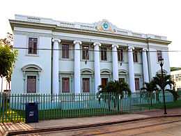
| 2 | Casa Consistorial De Mayagüez | 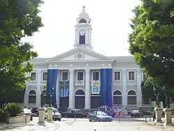 |
(#85003046) |
Peral St. 18°12′11″N 67°08′23″W / 18.203056°N 67.139722°W |
Mayagüez | City hall, from 1926 |
| 3 | Cementerio Municipal de Mayagüez |  |
(#88001247) |
Southern end of Post St. 18°10′00″N 67°07′30″W / 18.166667°N 67.125°W |
Mayagüez | Cemetery |
| 4 | Duran Esmoris Residencia | Upload image | (#88000655) |
Mendez Vigo B204 L204 Coordinates missing |
Mayagüez | Bungalow or Craftsman building from 1921, designed by Luis Fernando Nieva |
| 5 | Edificio José de Diego | 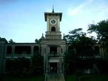 |
(#77001553) |
University of Puerto Rico campus 18°12′47″N 67°08′15″W / 18.213056°N 67.1375°W |
Mayagüez | Central administration building of the University of Puerto Rico at Mayagüez, from 1913 |
| 6 | Faro de la Isla de la Mona | 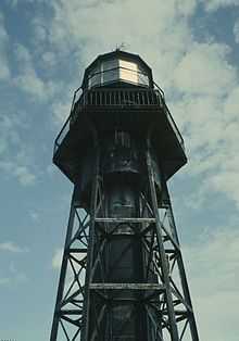 |
(#81000689) |
E side of Mona Island 18°05′18″N 67°50′48″W / 18.088333°N 67.846667°W |
Mona Island | |
| 7 | Gómez Residencia | Upload image | (#88000656) |
Mendez Vigo No. 60 Coordinates missing |
Mayagüez | Building from 1933 designed by architect Francisco Porrata Doria |
| 8 | Isla de Mona | 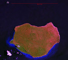 |
(#93001398) |
Mona Island 18°05′12″N 67°53′22″W / 18.086667°N 67.889444°W |
Mona Island | NRHP listing in 1993 gives 1493 as date of significance, presumably a Columbus landing date 500 years before? |
| 9 | La Case Solariega de Jose De Diego | Upload image | (#86000624) |
52 Liceo St. 18°12′07″N 67°08′11″W / 18.201944°N 67.136389°W |
Mayagüez | From 1890 |
| 10 | Logia Adelphia | Upload image | (#86000323) |
64 E. Sol St. 18°12′08″N 67°08′19″W / 18.202222°N 67.138611°W |
Mayagüez | From 1912, designed by Sabas Honore |
| 11 | Nazario Rivera Residencia | Upload image | (#88000686) |
Post St. No. 105 18°12′01″N 67°08′29″W / 18.200278°N 67.141389°W |
Mayagüez | From 1872, designed by Juaquín Hernández. |
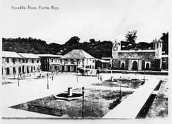
| 12 | Plaza Publica | Upload image | (#85003085) |
McKinley St. 18°12′11″N 67°08′21″W / 18.203056°N 67.139167°W |
Mayagüez | From 1760 |
| 13 | Ramírez Fuentes Residencia | Upload image | (#88000965) |
Calle Mendez Vigo #117 18°12′13″N 67°08′13″W / 18.203611°N 67.136944°W |
Mayagüez | Bungalow/Craftsman building from 1925, designed by Pascasio Fajardo |
| 14 | Residencia Heygler | Upload image | (#88000962) |
Calle Liceo #51 Coordinates missing |
Mayagüez | From 1830 |
| 15 | Residencia Ramirez De Arellano en Guanajibo | Upload image | (#86003192) |
PR 102 18°10′19″N 67°10′38″W / 18.171944°N 67.177222°W |
Mayagüez | Plantation style building from 1930 |
| 16 | Teatro Yagüez |  |
(#85003086) |
McKinley and Basora Sts. 18°12′11″N 67°08′29″W / 18.203056°N 67.141389°W |
Mayagüez | From 1909, designed by Sabas Honore et al. |
| 17 | US Custom House | 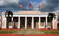 |
(#88000076) |
Ava. Gonzalez Clemente, esq. McKinley Coordinates missing |
Mayagüez | From 1924, designed by Rafael Carmoega |
| 18 | U.S. Post Office and Courthouse (Mayagüez, Puerto Rico) |  |
(#86001169) |
McKinley and Pilar DeFillo Sts. Coordinates missing |
Mayagüez | From 1935, designed by Louis A. Simpson |
Former listings
| [1] | Name on the Register | Image | Date listed | Date removed | Location | City or town | Summary |
|---|---|---|---|---|---|---|---|
| 1 | Antiqua Residencia de la Familia Nadal | Upload image | (#86003505) | 13 Dr. Barbosa S |
Mayagüez | ||
| 2 | Baldomero Baunin Residence | Upload image | (#88000687) | Calle Ramos Antonini No. 62 |
Mayagüez |
Moca
| [1] | Name on the Register | Image | Date listed[2] | Location | City or town | Description |
|---|---|---|---|---|---|---|
| 1 | Hacienda Iruena Manor House | 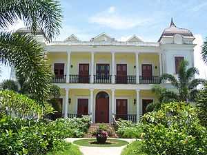 |
(#87000735) |
Km. 115.7 PR Rd. No. 2 Coordinates missing |
Moca | Renaissance/French Chateau style building from 1893. |
Quebradillas
| [1] | Name on the Register | Image | Date listed[2] | Location | City or town | Description |
|---|---|---|---|---|---|---|
| 1 | Puente Blanco | 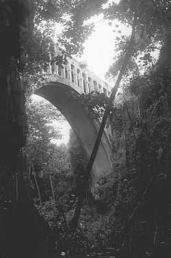 |
(#84003126) |
NE of Quebradillas off PR 485 18°29′17″N 66°55′35″W / 18.488056°N 66.926389°W |
Quebradillas | Bridge built in 1922 |
| 2 | Teatro Liberty | Upload image | (#88000963) |
Calle Rafols #157 18°28′31″N 66°56′23″W / 18.475278°N 66.939722°W |
Quebradillas | Building from 1921 designed by Arcilio Rosa |
Rincon
| [1] | Name on the Register | Image | Date listed[2] | Location | City or town | Description |
|---|---|---|---|---|---|---|
| 1 | Boiling Nuclear Superheater (BONUS) Reactor Facility | .png) |
(#07001194) |
Punta Higuero Sector, PR 413 18°21′59″N 67°16′07″W / 18.3664°N 67.2686°W |
Rincon | |
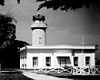
| 2 | Faro de Punta Higuero | 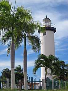 |
(#81000560) |
18°21′49″N 67°16′15″W / 18.3636°N 67.2708°W |
Rincon |
Sabana Grande
| [1] | Name on the Register | Image | Date listed[2] | Location | City or town | Description |
|---|---|---|---|---|---|---|
| 1 | Cementerio Masonico de la Resp. Logia Igualdad Num. 23 de Sabana Grande | Upload image | (#13000014) |
PR 121 18°04′44″N 66°58′08″W / 18.078928°N 66.968934°W |
Sabana Grande vicinity | |
| 2 | Church of San Isidro Labrador and Santa María de la Cabeza of Sabana Grande | 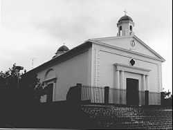 |
(#84000460) |
Ángel G. Martínez St. 18°04′53″N 66°57′36″W / 18.081389°N 66.96°W |
Sabana Grande | Church from 1844 |
| 3 | Hacienda San Francisco | 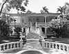 |
(#95000287) |
Callejón de la Hacienda 18°04′40″N 66°57′46″W / 18.077778°N 66.962778°W |
Sabana Grande | |
| 4 | Lassise-Schettini House | Upload image | (#87001823) |
Calle Ángel Ramírez, final 18°05′05″N 66°57′33″W / 18.084722°N 66.959167°W |
Sabana Grande | |
| 5 | Berta Sepulveda House | Upload image | (#94000624) |
37 Munoz Rivera St. 18°04′43″N 66°57′34″W / 18.078632°N 66.959441°W |
Sabana Grande |
San Germán
| [1] | Name on the Register | Image | Date listed[2] | Location | City or town | Description |
|---|---|---|---|---|---|---|
| 1 | Alcantarilla Pluvial sobre la Quebrada Manzanares | 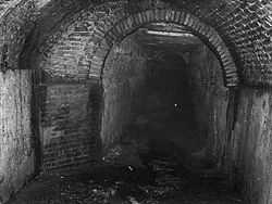 |
(#90000552) |
Calle Ferrocarril and Calle Esperanza Coordinates missing |
San Germán | Built in 1835 |
| 2 | Jaime Acosta y Fores Residence | Upload image | (#90000767) |
70 Calle Dr. Santiago Veve 18°05′07″N 67°02′25″W / 18.085278°N 67.040278°W |
San Germán | Vernacular Criollo house built in 1917 |
| 3 | Casa de los Ponce de León | Upload image | (#83002295) |
13 Calle Dr. Santiago Veve 18°02′43″N 67°05′03″W / 18.045278°N 67.084167°W |
San Germán | |
| 4 | Church San Germán de Auxerre | 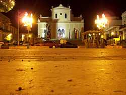 |
(#84000461) |
Calle de la Cruz 18°05′04″N 67°02′41″W / 18.084444°N 67.044722°W |
San Germán | Church built in 1688 |
| 5 | Convento de Porta Coeli | .jpg) |
(#76002252) |
Plaza Porta Coeli 18°05′04″N 67°02′40″W / 18.084444°N 67.044444°W |
San Germán | |
| 6 | Hacienda Buena Unión | Upload image | (#83002296) |
Vic. of San Germán Coordinates missing |
San Germán | |
| 7 | San Germán Historic District | 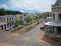 |
(#94000084) |
Roughly bounded by Calle Luna, Calle Estrella, Calle Concepción, Calle Javilla, and Calle Ferrocarril Coordinates missing |
San Germán | Historic district of colonial and other architecture dating to 1606 |
San Sebastián
| [1] | Name on the Register | Image | Date listed[2] | Location | City or town | Description |
|---|---|---|---|---|---|---|
| 1 | Church San Sebastián Mártir of San Sebastián | Upload image | (#84003132) |
Severo Arana St., Town Plaza 18°20′19″N 66°59′28″W / 18.338611°N 66.991111°W |
San Sebastián |
References
- ↑ 1.0 1.1 1.2 1.3 1.4 1.5 1.6 1.7 1.8 1.9 1.10 1.11 1.12 1.13 1.14 1.15 1.16 1.17 1.18 Numbers represent an ordering by significant words. Various colorings, defined here, differentiate National Historic Landmarks and historic districts from other NRHP buildings, structures, sites or objects.
- ↑ 2.0 2.1 2.2 2.3 2.4 2.5 2.6 2.7 2.8 2.9 2.10 2.11 2.12 2.13 2.14 2.15 2.16 The eight-digit number below each date is the number assigned to each location in the National Register Information System database, which can be viewed by clicking the number.
| Wikimedia Commons has media related to National Register of Historic Places in Puerto Rico. |