National Register of Historic Places listings in southern Puerto Rico
This is a list of properties and districts in the southern municipalities of Puerto Rico that are listed on the National Register of Historic Places. It includes places along the southern coast, and on islands, and in the peaks and on the south slope of Puerto Rico's Cordillera Central.
The area covered spans from the city of Yauco on the southwest coast to the Patillas municipality at the southeast. It also includes the non-shore towns of Adjuntas, Jayuya, and Villalba. All NRHP-listed places south, on the coasts, islands, slopes, and in the peaks of the Cordillera are included.
Names of places given are as they appear in the National Register, reflecting name as given in NRHP application at the date of listing. Note, the National Register name system does not accommodate Spanish á, ñ and other letters.
See also:
- National Register of Historic Places listings in Puerto Rico.
- National Register of Historic Places listings in northern Puerto Rico
- National Register of Historic Places listings in western Puerto Rico
- National Register of Historic Places listings in central Puerto Rico
- National Register of Historic Places listings in metropolitan San Juan, Puerto Rico
Southern municipalities
Adjuntas
| [1] | Name on the Register | Image | Date listed[2] | Location | City or town | Description |
|---|---|---|---|---|---|---|
| 1 | Las Cabanas Bridge | Upload image | (#95000838) |
PR 135 over Río de las Vacas 18°10′46″N 66°44′10″W / 18.179583°N 66.73625°W |
Adjuntas, Puerto Rico | ( See also Capáez and Garzas. Does this bridge between those two subareas? ) |
| 2 | Quinta Vendrell | Upload image | (#06000028) |
Junction of PR 143 and PR 123 18°08′53″N 66°41′29″W / 18.148056°N 66.691389°W |
Portugues |
Arroyo
| [1] | Name on the Register | Image | Date listed[2] | Location | City or town | Description |
|---|---|---|---|---|---|---|
| 1 | Punta Figuras Light | .jpg) |
(#81000687) |
SE of Arroyo 17°57′18″N 66°02′51″W / 17.955°N 66.0474°W |
Arroyo |
Coamo
| [1] | Name on the Register | Image | Date listed[2] | Location | City or town | Description |
|---|---|---|---|---|---|---|
| 1 | Casa Blanca | 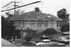 |
(#92000379) |
17 Jose I. Quinton St. 18°04′55″N 66°21′07″W / 18.0819°N 66.3519°W |
Coamo | Spanish Creole architecture from 1865 |
| 2 | Church San Blas de Illescas of Coamo | 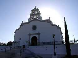 |
(#84000463) |
Mario Braschi St. 18°04′57″N 66°21′24″W / 18.0825°N 66.3567°W |
Coamo | Latin American Baroque architecture of a church from 1661 |
| 3 | General Méndez Vigo Bridge | 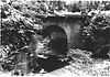 |
(#95000839) |
Near Coamo Coordinates missing |
Coamo | Brick barrel vault bridge from 1898, by US Corps of Engineers, also known as Puente Rio las Minas |
| 4 | Hermitage Church of Nuestra Señora de Valvanera of Coamo | Upload image | (#86000700) |
Quinton and Carrion Mafuro Sts. 18°04′53″N 66°21′35″W / 18.0814°N 66.3597°W |
Coamo | Church from 1685 |
| 5 | Padre Inigo Bridge | Upload image | (#95000840) |
Near Coamo Coordinates missing |
Coamo | Brick barrel vault bridge from 1853 |
| 6 | Pico Pomar Residence | Upload image | (#88000961) |
Corner of Mario Braschi and Jose Quinton St. 18°04′56″N 66°21′23″W / 18.0822°N 66.3564°W |
Coamo | Spanish Neoclassical building from 1840, also known as Coamo Historic Museum |
| 7 | Puente de las Calabazas | Upload image | (#09000042) |
Near Coamo Coordinates missing |
Coamo | Lattice girder bridge from 1882 |
Guayama
| [1] | Name on the Register | Image | Date listed[2] | Location | City or town | Description |
|---|---|---|---|---|---|---|
| 1 | Casa Cautino | 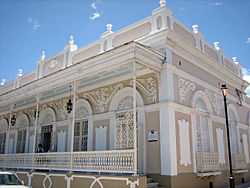 |
(#84003137) |
Vicente Pales Ares St. 17°59′16″N 66°06′49″W / 17.9878°N 66.1136°W |
Guayama | Classical Revival building from 1887 |
| 2 | Cayey Bridge | 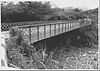 |
(#95000845) |
Near Guayama 18°00′09″N 66°06′55″W / 18.0025°N 66.1153°W |
Guayama | An iron lateral lattice girder bridge from 1891 |
| 3 | Eleuterio Derkes Grammar School | Upload image | (#87001312) |
Jose Maria Angueli St. 17°59′01″N 66°06′47″W / 17.9836°N 66.1131°W |
Guayama | Neo-Classical school built in 1909 |
| 4 | Iglesia Parroquial de San Antonio de Padua de Guayama | Upload image | (#76002248) |
5 Ashford St. Coordinates missing |
Guayama | Built in 1775 |
| 5 | Ingenio Azucarero Vives | .jpg) |
(#76002249) |
Avenida Central, Barrio Machete 17°58′45″N 66°07′03″W / 17.9792°N 66.1175°W |
Guayama |
Guayanilla
| [1] | Name on the Register | Image | Date listed[2] | Location | City or town | Description |
|---|---|---|---|---|---|---|
| 1 | Padre Nazario School | Upload image | (#12000936) |
4 Concepcion Street Coordinates missing |
Guayanilla |
Jayuya
| [1] | Name on the Register | Image | Date listed[2] | Location | City or town | Description |
|---|---|---|---|---|---|---|
| 1 | La Piedra Escrita | Upload image | (#02001720) |
Coordinates missing |
Jayuya | Prehistoric rock art site |
Juana Diaz
| [1] | Name on the Register | Image | Date listed[2] | Location | City or town | Description |
|---|---|---|---|---|---|---|
| 1 | Church San Juan Bautista y San Ramón Nonato of Juana Díaz | Upload image | (#84000465) |
Town Plaza 18°03′18″N 66°30′21″W / 18.055°N 66.5058°W |
Juana Diaz | Church from 1807 |
| 2 | Cueva Lucero | Upload image | (#08000936) |
Near Juana Diaz Coordinates missing |
Juana Diaz | Prehistoric rock art site |
Patillas
| [1] | Name on the Register | Image | Date listed[2] | Location | City or town | Description |
|---|---|---|---|---|---|---|
| 1 | Maria Davila Semidey School | Upload image | (#12000939) |
300 Munoz Rivera Street Coordinates missing |
Patillas |
Penuelas
| [1] | Name on the Register | Image | Date listed[2] | Location | City or town | Description |
|---|---|---|---|---|---|---|
| 1 | Daniel Webster School | Upload image | (#12000940) |
255 Luis Munoz Rivera Street Coordinates missing |
Penuelas |
Ponce
| [1] | Name on the Register | Image | Date listed[2] | Location | Barrio | Description |
|---|---|---|---|---|---|---|
| 1 | Albergue Caritativo Tricoche | 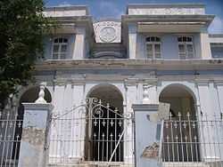 |
(#87000769) |
Tricoche St. 18°01′22″N 66°36′56″W / 18.0228°N 66.6156°W |
Segundo | Hospital in Neoclásico Isabelino style from 1885 |
| 2 | Antiguo Cuartel Militar Español de Ponce | 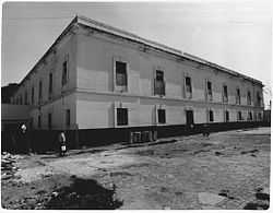 |
(#87000772) |
Calle Castillo Final 18°01′02″N 66°36′32″W / 18.0172°N 66.6089°W |
Quinto | Spanish military headquarters in Ponce, in Neoclásico Isabelino style, from 1894 |
| 3 | Antiguo Hospital Militar Español de Ponce | 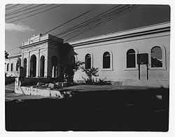 |
(#87000770) |
Leon, Atocha and Bondad Sts. 18°01′17″N 66°36′54″W / 18.0214°N 66.615°W |
Segundo | Neoclásico Isabelino style, from 1897 |
| 4 | Armstrong-Poventud House | 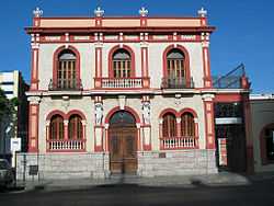 |
(#87001821) |
Calle Union No. 9 18°00′48″N 66°36′54″W / 18.0133°N 66.615°W |
Segundo | Neoclassical designed by Manuel Domenech and built in 1899 |
| 5 | Banco Crédito y Ahorro Ponceño | 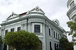 |
(#87001002) |
Marina and Amor Sts. 18°00′48″N 66°36′48″W / 18.0133°N 66.6133°W |
Tercero | Beaux Arts design by Francisco Porrata Doria, from 1924 |
| 6 | Banco de Ponce | 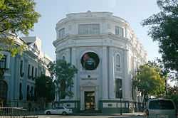 |
(#87001003) |
Amor and Comercio Sts. 18°00′45″N 66°36′48″W / 18.0125°N 66.6133°W |
Tercero | Beaux Arts design by Francisco Porrata Doria, also from 1924 |
| 7 | Casa Alcaldía de Ponce-City Hall | 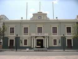 |
(#86003197) |
South, Las Delicias Square 18°00′46″N 66°36′52″W / 18.0128°N 66.6144°W |
Primero | Neoclásico Isabelino-style City Hall, from 1846 |
| 8 | Casa de la Masacre | 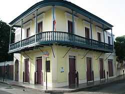 |
(#05001098) |
Marina St. No. 32 18°00′39″N 66°36′50″W / 18.0108°N 66.6139°W |
Cuarto | Ponce Creole building related to the Ponce Massacre of 1937 by Blas Silva |
| 9 | Casa Paoli | 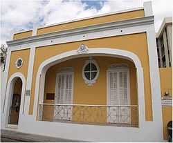 |
(#09000769) |
14 Mayor St. 18°00′36″N 66°36′46″W / 18.01°N 66.6127°W |
Cuarto | Neoclassical design with other 20th-century elements by Manuel V. Domenech |
| 10 | Casa Vives | Upload image | (#13000013) |
88 Calle Paseo Atocha Coordinates missing |
Ponce vicinity | |
| 11 | Casino de Ponce | 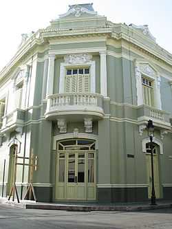 |
(#87001818) |
Calle Marina & Calle Luna 18°00′43″N 66°36′49″W / 18.0119°N 66.6136°W |
Cuarto | Second Empire- and Neo-Rococo-style building from 1922, designed by Agustin Camilo Gonzalez |
| 12 | Castillo de Serralles | 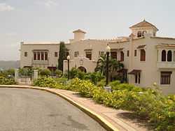 |
(#80004494) |
Cerro El Vigia 18°01′41″N 66°37′05″W / 18.0281°N 66.6181°W |
Portugues Urbano | Spanish Mediterranean style "castle" from 1926 by Pedro Aldolfo de Castro |
| 13 | Catedral Nuestra Señora de Guadalupe of Ponce | 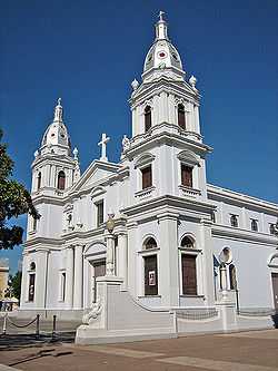 |
(#84000467) |
Town Plaza 18°00′42″N 66°36′30″W / 18.0118°N 66.6084°W |
Segundo | Neoclassical building from 1835 by Francisco Porrata Doria |
| 14 | Cementerio Antiguo de Ponce |  |
(#84003149) |
Torres no. 1 and Frontispicio St. 18°01′14″N 66°37′18″W / 18.0206°N 66.6217°W |
Segundo | Neo-classical. 1864 enlargement designed by Nieto Blajol Iglesia, from 1842 |
| 15 | Cementerio Católico San Vicente de Paul | 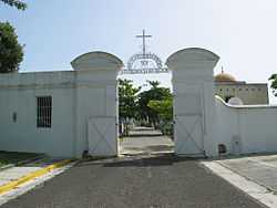 |
(#88001249) |
Off PR-123 18°01′07″N 66°38′04″W / 18.0186°N 66.6344°W |
Segundo | Classical Revival, Spanish Revival, Art Deco from 1901, also called Cementerio Católico de Ponce |
| 16 | Centro Ceremonial Indígena |  |
(#78003381) |
Road PR-503, Barrio Portugues, Ponce 18°02′32″N 66°37′18″W / 18.0422°N 66.6217°W |
Portugues | Also known as Batey Indígena de Tibes. (Also, Tibes Indigenous Ceremonial Center ) |
| 17 | Edificio Empresas Ferré | Upload image | (#13000638) |
834 Eugenio Maria de Hostos Ave. 17°58′55″N 66°37′13″W / 17.981963°N 66.620154°W |
Playa | |
| 18 | Edificio Municipal de la Playa de Ponce | Upload image | (#13000639) |
28 Alfonso XII St. 17°58′55″N 66°37′16″W / 17.982005°N 66.621188°W |
Playa | |
| 19 | Faro de la Isla de Caja de Muertos | 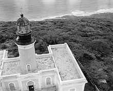 |
(#81000690) |
Isla Caja de Muertos 17°53′35″N 66°31′16″W / 17.893°N 66.5211°W |
Playa | Neo-classical light house from 1887 |
| 20 | Faro del Puerto de Ponce | 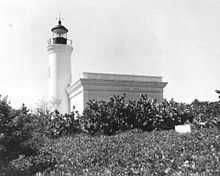 |
(#81000691) |
Isla Cardona, Ponce Harbor 17°57′24″N 66°38′06″W / 17.9568°N 66.635°W |
Playa | Neo-classical light house from 1889 |
| 21 | Font-Ubides House | 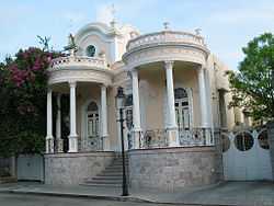 |
(#87001825) |
Calle Castillo No. 34 18°00′41″N 66°36′43″W / 18.0114°N 66.6119°W |
Quinto | Classical Revival, Art Nouveau building by Blas C. Silva, from 1913 |
| 22 | Casa Miguel C. Godreau | 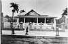 |
(#86000894) |
146 Calle Reina 18°00′51″N 66°37′08″W / 18.0142°N 66.6189°W |
Segundo | House from 1919, designed by Julio Conesa |
| 23 | Hacienda Buena Vista | 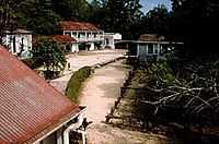 |
(#91001499) |
Near Corral Viejo 18°09′52″N 66°37′32″W / 18.1644°N 66.6256°W |
Magueyes | Colonial-style coffee plantation from 1833 |
| 24 | Iglesia de la Santísima Trinidad | 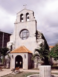 |
(#86002766) |
Marina St. at jct. of Mayor and Abolicion Sts. 18°00′32″N 66°36′47″W / 18.0089°N 66.6131°W |
Cuarto | Late Gothic Revival, Mission/Spanish Revival church from 1926 |
| 25 | McCabe Memorial Church | _in_Barrio_Playa_in_Ponce.jpg) |
(#08000283) |
835 Eugenio Maria de Hostos Ave. 17°59′20″N 66°37′01″W / 17.9889°N 66.6169°W |
Playa | Neo-gothic church from 1908 designed by Antonin Nechodoma |
| 26 | Mercado de las Carnes | 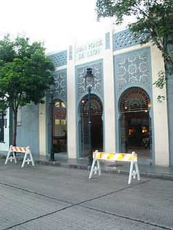 |
(#86003199) |
Alley connecting Mayor and Leon Sts. 18°01′03″N 66°36′48″W / 18.0175°N 66.6133°W |
Quinto | Art Deco meat market from 1926 by Rafael Carmoega |
| 27 | Missionary Society of the Methodist Episcopal Church | 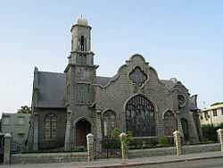 |
(#87001822) |
Calle Villa No. 135 18°00′44″N 66°36′58″W / 18.0122°N 66.6161°W |
Primero | Bungalow, integrating Neo-Gothic, Spanish Revival, Spanish Baroque, and byzantine elements, from 1907, designed by Antonin Nechodoma |
| 28 | Oppenheimer House | 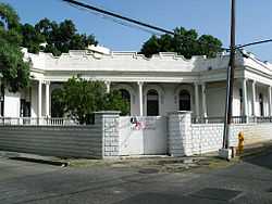 |
(#87001824) |
Calle Salud No. 47 18°00′41″N 66°36′43″W / 18.0114°N 66.6119°W |
Cuarto | Spanish-Art Nouveau house from 1913, designed by Alfredo B. Weichers |
| 29 | Parque de Bombas de Ponce |  |
(#84003150) |
Plaza las Delicias 18°00′49″N 66°36′51″W / 18.0136°N 66.6142°W |
Segundo | Fire station in Gothic style, from 1882 by Maximo de Meana y Guridi. |
| 30 | Ponce High School | 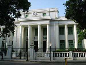 |
(#87001310) |
Christina St. 18°00′49″N 66°36′37″W / 18.0136°N 66.6103°W |
Tercero | Classical Revival building from 1915, designed by Adrian C. Finlayson |
| 31 | Ponce YMCA Building | Upload image | (#12000331) |
7843 Calle Nazaret Urbanizacion Santa Maria Coordinates missing |
Primero | Part of the Rafael Rios Rey Multiple Property Submission |
| 32 | Puente Rio Portugues | Upload image | (#14001134) |
Eugenio Maria de Hostos Ave. 17°59′36″N 66°36′55″W / 17.993399°N 66.615293°W |
Playa | |
| 33 | Rosaly-Batiz House | 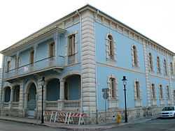 |
(#87002768) |
125 Villa St. 18°00′43″N 66°37′10″W / 18.0119°N 66.6194°W |
Primero | Italian Renaissance Palazzo house by Manuel V. Domenech from 1897 |
| 34 | Salazar-Candal House | 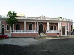 |
(#88000663) |
Calle Isabel No. 53 18°00′50″N 66°36′43″W / 18.0139°N 66.6119°W |
Tercero | Neo-Classic, Art Nouveau, and Spanish Revival house from 1911, designed by Blas C. Silva |
| 35 | Subira House | 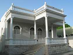 |
(#87001826) |
Calle Reina No. 107 18°00′58″N 66°36′59″W / 18.0161°N 66.6164°W |
Segundo | Ponce Creole house from 1910, designed by Blas C. Silva |
| 36 | Casa Fernando Luis Toro | Upload image | (#86000421) |
Calle Obispado No. 3, La Alhambra 18°01′11″N 66°36′23″W / 18.0197°N 66.6064°W |
Machuelo Abajo | Victorian, Georgian, Neo-classic, Beaux Arts, Spanish Revival and Catalonian Modernism from 1927, designed by Francisco Porrata Doria |
| 37 | US Custom House |  |
(#88000073) |
Calle Bonaire at Calle Aduana Playa de Ponce 17°58′54″N 66°37′13″W / 17.9817°N 66.6203°W |
Playa | Spanish colonial, possibly by Albert B. Nichols from 1842 |
| 38 | Villaronga House | 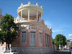 |
(#84003151) |
106 Reina St. 18°00′52″N 66°37′01″W / 18.0144°N 66.6169°W |
Segundo | Classical Revival house from 1921, designed by Alfredo B. Wiechers |
| 39 | Zaldo de Nebot Residencia | Upload image | (#88000643) |
Calle Marina No. 27 18°00′41″N 66°36′50″W / 18.0114°N 66.6139°W |
Primero | Classical Revival building from 1895 |
Salinas
| [1] | Name on the Register | Image | Date listed[2] | Location | City or town | Description |
|---|---|---|---|---|---|---|
| 1 | Central Aguirre Historic District |  |
(#02001208) |
Near Salinas 17°57′36″N 66°13′39″W / 17.96°N 66.2275°W |
Salinas | From 1899 |
Santa Isabel
| [1] | Name on the Register | Image | Date listed[2] | Location | City or town | Description |
|---|---|---|---|---|---|---|
| 1 | Dr. Martin G. Brumbaugh Graded School | Upload image | (#10001217Show) |
33 Eugenio M. de Hostos St. Coordinates missing |
Santa Isabel |
Villalba
| [1] | Name on the Register | Image | Date listed[2] | Location | City or town | Description |
|---|---|---|---|---|---|---|
| 1 | Walter McK. Jones School | Upload image | (#12001249) |
28 Luis Muñoz Rivera St. 18°07′50″N 66°29′35″W / 18.1305°N 66.4931°W |
Villalba vicinity |
Yauco
References
| Wikimedia Commons has media related to National Register of Historic Places in Puerto Rico. |
- ↑ 1.0 1.1 1.2 1.3 1.4 1.5 1.6 1.7 1.8 1.9 1.10 1.11 1.12 1.13 Numbers represent an ordering by significant words. Various colorings, defined here, differentiate National Historic Landmarks and historic districts from other NRHP buildings, structures, sites or objects.
- ↑ 2.0 2.1 2.2 2.3 2.4 2.5 2.6 2.7 2.8 2.9 2.10 2.11 2.12 2.13 The eight-digit number below each date is the number assigned to each location in the National Register Information System database, which can be viewed by clicking the number.