National Register of Historic Places listings in eastern Puerto Rico
This portion of National Register of Historic Places listings in Puerto Rico covers the eastern region of Puerto Rico, from Loiza in the northeast to Maunabo in the southeast. It also includes the islands of Culebras and Vieques.
See also:
- National Register of Historic Places listings in southern Puerto Rico
- National Register of Historic Places listings in northern Puerto Rico
- National Register of Historic Places listings in western Puerto Rico
- National Register of Historic Places listings in central Puerto Rico
- National Register of Historic Places listings in metropolitan San Juan, Puerto Rico
Names of places given are as appear in the National Register, reflecting name as given in NRHP application at the date of listing. Note, the National Register name system does not accommodate Spanish á, ñ and other letters.
Eastern region
Canóvanas
| [1] | Name on the Register | Image | Date listed[2] | Location | City or town | Description |
|---|---|---|---|---|---|---|
| 1 | Villarán Bridge | 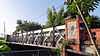 |
(#95000835) |
18°22′52″N 65°53′33″W / 18.38111111°N 65.8925°W |
Canovanas |
Ceiba
| [1] | Name on the Register | Image | Date listed[2] | Location | City or town | Description |
|---|---|---|---|---|---|---|
| 1 | Ceiba Fire Station | Upload image | (#13000012) |
226 Lauro Piñero Avenue 18°15′59″N 65°38′52″W / 18.26625°N 65.64785278°W |
Ceiba |
Culebra
| [1] | Name on the Register | Image | Date listed[2] | Location | City or town | Description |
|---|---|---|---|---|---|---|
| 1 | Faro Isla de Culebritas | 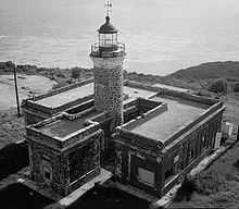 |
(#81000686) |
Isla Culebrita 18°18′09″N 65°13′07″W / 18.3025°N 65.21861111°W |
Culebra | Lighthouse on Isla de Culebritas |
Fajardo
| [1] | Name on the Register | Image | Date listed[2] | Location | City or town | Description |
|---|---|---|---|---|---|---|
| 1 | Church Santiago Apóstol of Fajardo | 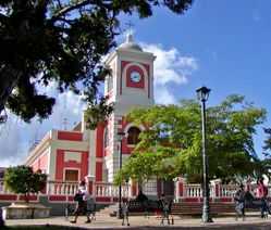 |
(#84003144) |
Town Plaza 18°19′37″N 65°39′12″W / 18.3269°N 65.6533°W |
Fajardo | A church from 1776 |
| 2 | Faro de las Cabezas de San Juan | 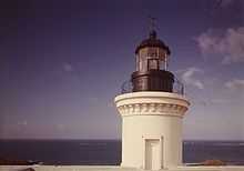 |
(#81000692) |
Vic. of Saroco 18°22′52″N 65°37′06″W / 18.3811°N 65.6182°W |
Fajardo | A lighthouse |
| 3 | United States Customs House (Fajardo, Puerto Rico) | Upload image | (#88000077) |
Calle Union 18°20′09″N 65°37′51″W / 18.3358°N 65.6308°W |
Fajardo | From 1930, designed by Albert B. Nichols |
Humacao
| [1] | Name on the Register | Image | Date listed[2] | Location | City or town | Description |
|---|---|---|---|---|---|---|
| 1 | Casa Roig | Upload image | (#77001550) |
Antonio López 66 18°09′03″N 65°49′37″W / 18.1508°N 65.8269°W |
Humacao | A Prairie School building from 1920 |
| 2 | Church Dulce Nombre de Jesús of Humacao | 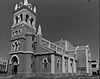 |
(#84003140) |
Town Plaza 18°09′07″N 65°49′36″W / 18.1519°N 65.8267°W |
Humacao | Late Gothic Revival church from 1869 |
| 3 | Guzman Family Pantheon | 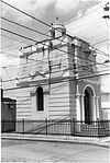 |
(#95000436) |
Jct. of Padre Rivera and Miguel Casillas Sts. 18°09′15″N 65°49′41″W / 18.1542°N 65.8281°W |
Humacao | Eclectic style pantheon from 1864 |
| 4 | Humacao Custom House |  |
(#95000599) |
Marina St. at jct. with Aduana St. 18°10′01″N 65°44′42″W / 18.1669°N 65.745°W |
Humacao | Spanish Colonial building from 1872, designed by Julian Cruellas y Rovira |
| 5 | Humacao City Hall | 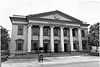 |
(#95000596) |
Jct. of Dr. Vidal St. and Antonio López St. 18°09′05″N 65°49′28″W / 18.1514°N 65.8244°W |
Humacao | Classical Revival style courthouse from 1925, the Casa Alcaldía de Humacao |
| 6 | Palmira López de Pereyo House | Upload image | (#95000435) |
Jct. of Font Martelo and Minerva Sts. 18°09′09″N 65°49′21″W / 18.1525°N 65.8225°W |
Humacao | Prairie School house from 1930 designed by Francisco Valines Cofresi (try also Palmira Pereyo House ) |
| 7 | Antonia Sáez School | Upload image | (#95000597) |
Font Martelo St. at jct. with Isidro St. 18°09′11″N 65°49′51″W / 18.1531°N 65.8308°W |
Humacao | A Mission/Spanish Revival school from 1922 |
Juncos
| [1] | Name on the Register | Image | Date listed[2] | Location | City or town | Description |
|---|---|---|---|---|---|---|
| 1 | Jose Miguel Gallardo School | Upload image | (#12000937) |
Jct. of Paseo Escute Final & Algarin St Coordinates missing |
Juncos vicinity |
Las Piedras
| [1] | Name on the Register | Image | Date listed[2] | Location | City or town | Description |
|---|---|---|---|---|---|---|
| 1 | Cueva del Indio | Upload image | (#03000884) |
Near Las Piedra City 18°11′50″N 65°52′24″W / 18.1972°N 65.8733°W |
Loiza |
Loiza
| [1] | Name on the Register | Image | Date listed[2] | Location | City or town | Description |
|---|---|---|---|---|---|---|
| 1 | Cueva de Los Indios | Upload image | (#82003823) |
Near Loiza Coordinates missing |
Loiza | |
| 2 | Parroquia del Espíritu Santo y San Patricio | 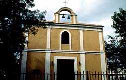 |
(#76002251) |
Plaza de Loiza 18°26′00″N 65°53′00″E / 18.4333°N 65.8833°E |
Loiza | Dates from 1729 |
Luquillo
| [1] | Name on the Register | Image | Date listed[2] | Location | City or town | Description |
|---|---|---|---|---|---|---|
| 1 | Williams Products Corporation | Upload image | (#12000938) |
PR 992, KM 0.3 18°22′18″N 65°43′04″W / 18.37155°N 65.71790°W |
Luquillo vicinity |
Maunabo
| [1] | Name on the Register | Image | Date listed[2] | Location | City or town | Description |
|---|---|---|---|---|---|---|
| 1 | Faro de Punta de la Tuna | 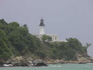 |
(#81000688) |
Near Guayama 17°59′04″N 65°53′01″W / 17.9844°N 65.8836°W |
Maunabo |
Naguabo
| [1] | Name on the Register | Image | Date listed[2] | Location | City or town | Description |
|---|---|---|---|---|---|---|
| 1 | Bridge No. 122 | 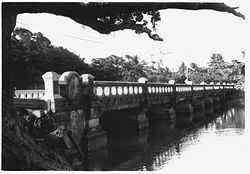 |
(#95000836) |
Near Naguabo 18°11′16″N 65°43′48″W / 18.1878°N 65.73°W |
Naguabo | |
| 2 | Church Nuestra Señora del Rosario of Naguabo | 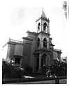 |
(#84000456) |
Town Plaza 18°12′51″N 65°44′12″W / 18.2142°N 65.7367°W |
Naguabo | 1856 Spanish Colonial style building designed by Mariano Bosch |
| 3 | Villa Del Mar | Upload image | (#83002293) |
PR 3 18°11′30″N 65°42′50″W / 18.1917°N 65.7139°W |
Naguabo | 1917 building also known as "El Castillo" |
Rio Grande
| [1] | Name on the Register | Image | Date listed[2] | Location | City or town | Description |
|---|---|---|---|---|---|---|
| 1 | Rio Grande Fire Station | Upload image | (#12001248) |
Address Restricted |
Rio Grande vicinity |
San Lorenzo
| [1] | Name on the Register | Image | Date listed[2] | Location | City or town | Description |
|---|---|---|---|---|---|---|
| 1 | Nuestra Señora de las Mercedes de San Miguel de Hato Grande | Upload image | (#83004194) |
Colon St. 18°11′32″N 65°57′40″W / 18.1922°N 65.9611°W |
San Lorenzo | Also known as Las Mercedes, this Classical Revival style building was built in 1737 |
| 2 | Residencia Machin-Ramos | Upload image | (#88001180) |
Calle Eugenio Sánchez López 18°11′32″N 65°57′41″W / 18.1922°N 65.9614°W |
San Lorenzo | Spanish Colonial building from 1883 |
Vieques
| [1] | Name on the Register | Image | Date listed[2] | Location | City or town | Description |
|---|---|---|---|---|---|---|
| 1 | Rafael Acevedo House | Upload image | (#94000249) |
Víctor Duteil St. between San José and Baldorioty Sts. 18°09′04″N 65°26′35″W / 18.1511°N 65.4431°W |
Isabel Segunda | House built in Vieques Creole / Neoclasico style in 1900 |
| 2 | Algodones 2 (12VPr2-204) | Upload image | (#91001037) |
Address Restricted |
Barrio Puerto Diablo, Vieques | A village site, an archeological site |
| 4 | Algodones 3 (12VPr2-205) | Upload image | (#91001038) |
Address Restricted |
Barrio Puerto Diablo, Vieques | Another village site, an archeological site |
| 5 | Algodones 6 (12VPr2-229) | Upload image | (#91001032) |
Address Restricted |
Barrio Puerto Diablo, Vieques | Another village site, an archeological site |
| 6 | Camp Garcia (Campo Asilo) 3 (12VPr2-164) | Upload image | (#91001041) |
Address Restricted |
Barrio Puerto Ferro, Vieques | Site of petroglyphs |
| 7 | Casa Alcaldía de Vieques | Upload image | (#94000174) |
Jct. of Carlos LeBrum St. and Benitez Guzman St. 18°09′03″N 65°26′30″W / 18.1508°N 65.4417°W |
Isabel Segunda | Town hall, from 1850 |
| 8 | Casa Augusto Delerme | Upload image | (#93001555) |
7 Benitez Guzman St. 18°09′04″N 65°26′31″W / 18.1511°N 65.4419°W |
Isabel Segunda | A "4-Room Creole House", from 1850 |
| 9 | Casa Delerme-Anduze No. 2 | Upload image | (#93001205) |
355 Antonio Mellado St. 18°09′03″N 65°26′31″W / 18.1508°N 65.4419°W |
Isabel Segunda | A "six-room Creole house" from 1876 |
| 10 | Casa de Jaime Puig Lemoine | Upload image | (#94000363) |
18°08′59″N 65°26′35″W / 18.1497°N 65.4431°W |
Isabel Segunda | Bungalow/Craftsman house from 1930, designed by J. P. Lemoine |
| 11 | Central Playa Grande | Upload image | (#92001236) |
Address Restricted |
Barrio Llave, Vieques | A site with architecture by Matias Hjardemaal and others |
| 12 | Delerme-Anduze House | Upload image | (#93001556) |
361 Antonio Mellado St. 18°08′59″N 65°26′29″W / 18.1497°N 65.4414°W |
Isabel Segunda | A Creole gallery house |
| 13 | Faro de Vieques | .jpg) |
(#77001551) |
Off PR 38 18°09′16″N 65°26′38″W / 18.1545°N 65.4438°W |
Isabel Segunda | Lighthouse built in 1896 |
| 14 | Fuerte de Vieques | 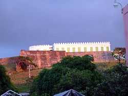 |
(#77001552) |
Calle del Fuerte 18°08′50″N 65°26′35″W / 18.1472°N 65.4431°W |
Isabel Segunda | Fort built in 1845 which now houses the Vieques Museum of Art and History |
| 15 | Hacienda Casa del Francés | Upload image | (#77001548) |
Near Esperanza 18°06′05″N 65°28′26″W / 18.1014°N 65.4739°W |
Esperanza | Plantation architecture from 1910 |
| 16 | Laguna Jalova Archeological District | Upload image | (#92001237) |
Address Restricted |
Barrio Puerto Diablo, Vieques | Also known as "Western Friendly Front Line" |
| 17 | Las Tumbas de J. J. Maria le Guillou | Upload image | (#94000923) |
Near Isabel Segunda 18°09′13″N 65°25′56″W / 18.1536°N 65.4322°W |
Isabel Segunda | Classical Revival style, from 1843 |
| 18 | Le Pistolet (12VPr2-168) | Upload image | (#91001040) |
Address Restricted |
Barrio Punta Arenas, Vieques | |
| 19 | Llave 13 (12VPr2-175) | Upload image | (#91001036) |
Address Restricted |
Barrio Llave, Vieques | |
| 20 | Loma Jalova 3 (12VPr2-219) | Upload image | (#91001034) |
Address Restricted |
Barrio Puerto Diablo, Vieques | |
| 21 | Monte Largo 2 (12VPr2-172) | Upload image | (#91001042) |
Address Restricted |
Barrio Puerto Diablo, Vieques | |
| 22 | Paramayon 2 | Upload image | (#92001241) |
Address Restricted |
Barrio Llave, Vieques | |
| 23 | Playa Grande 9 (12VPr2-212) | Upload image | (#91001035) |
Address Restricted |
Barrio Llave, Vieques | |
| 24 | Playa Vieja | Upload image | (#92001235) |
Address Restricted |
Barrio Punta Arenas, Vieques | |
| 25 | Punta Jalova | Upload image | (#92001239) |
Address Restricted |
Barrio Puerto Diablo, Vieques | |
| 26 | Resolucion Historic District | Upload image | (#92001242) |
Address Restricted |
Barrio Punta Arenas, Vieques | Work designed by T. J. J. M. Leguillou and others |
| 27 | Smaine-Ortiz House | Upload image | (#93001554) |
341 Antonio Mellado St. 18°08′53″N 65°26′29″W / 18.1481°N 65.4414°W |
Isabel Segunda | |
| 28 | Ventana Archeological District | Upload image | (#92001238) |
Address Restricted |
Barrio Llave, Vieques | |
| 29 | Ventana 4 (12VPr2-171) | Upload image | (#91001039) |
Address Restricted |
Barrio Punta Arenas, Vieques | |
| 30 | Vieques Pharmacy | Upload image | (#94000061) |
Jct. of Carlos LeBrun and Víctor Duteil Sts. 18°09′02″N 65°26′30″W / 18.1506°N 65.4417°W |
Isabel Segunda | |
| 30 | Yanuel 8 (12VPr2-173) | Upload image | (#91001043) |
Address Restricted |
Barrio Puerto Diablo, Vieques | |
| 31 | Yanuel 9 (12VPr2-220) | Upload image | (#91001033) |
Address Restricted |
Barrio Puerto Diablo, Vieques |
Yabucoa
| [1] | Name on the Register | Image | Date listed[2] | Location | City or town | Description |
|---|---|---|---|---|---|---|
| 1 | Yabucoa Fire Station | Upload image | (#13000015) |
22 Luis Muñoz Rivera Street 18°03′08″N 65°52′38″W / 18.0521°N 65.87725278°W |
Yabucoa |
References
- ↑ 1.0 1.1 1.2 1.3 1.4 1.5 1.6 1.7 1.8 1.9 1.10 1.11 1.12 1.13 1.14 Numbers represent an ordering by significant words. Various colorings, defined here, differentiate National Historic Landmarks and historic districts from other NRHP buildings, structures, sites or objects.
- ↑ 2.0 2.1 2.2 2.3 2.4 2.5 2.6 2.7 2.8 2.9 2.10 2.11 2.12 2.13 2.14 The eight-digit number below each date is the number assigned to each location in the National Register Information System database, which can be viewed by clicking the number.
| Wikimedia Commons has media related to National Register of Historic Places in Puerto Rico. |