National Register of Historic Places listings in Yukon–Koyukuk Census Area, Alaska

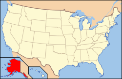
Location of the Yukon-Koyukuk Census Area in Alaska
This is a list of the National Register of Historic Places listings in Yukon–Koyukuk Census Area, Alaska.
This is intended to be a complete list of the properties and districts on the National Register of Historic Places in Yukon-Koyukuk Census Area, Alaska, United States. The locations of National Register properties and districts for which the latitude and longitude coordinates are included below, may be seen in a Google map.[1]
There are 17 properties and districts listed on the National Register in the census area.
- This National Park Service list is complete through NPS recent listings posted May 1, 2015.[2]
Current listings
| [3] |
Name on the Register[4] |
Image |
Date listed[5] |
Location |
City or town |
Description |
|---|
| 1 |
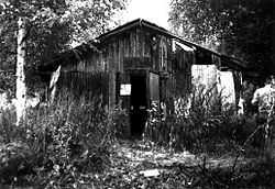
Ed Beiderman Fish Camp |
|
01987-07-20-0000July 20, 1987
(#87001204) |
Left bank of the Yukon River ½ mile down across from the Kandick River
65°21′58″N 143°18′01″W / 65.366111°N 143.300278°W / 65.366111; -143.300278 (Ed Beiderman Fish Camp) |
Eagle |
|
| 2 |
Bettles Lodge |
Upload image |
01997-05-08-0000May 8, 1997
(#97000401) |
Bettles Field, off Winter Trail, approximately 3.5 miles east of Bettles
66°55′07″N 151°30′59″W / 66.918611°N 151.516389°W / 66.918611; -151.516389 (Bettles Lodge) |
Bettles |
|
| 3 |
Central House |
Upload image |
01978-07-31-0000July 31, 1978
(#78003431) |
Mile 128 on the Steese Highway
65°34′20″N 144°47′45″W / 65.572222°N 144.795833°W / 65.572222; -144.795833 (Central House) |
Central |
|
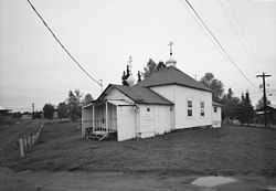
| 4 |
Christ Church Mission |
|
01980-05-08-0000May 8, 1980
(#80004572) |
In Anvik
62°39′16″N 160°12′03″W / 62.654444°N 160.200833°W / 62.654444; -160.200833 (Christ Church Mission) |
Anvik |
|
| 5 |
Coal Creek Historic Mining District |
|
01995-05-04-0000May 4, 1995
(#95000573) |
Along the Yukon River, southeast of Circle, in the Yukon-Charley Rivers National Park
65°18′29″N 143°11′27″W / 65.308056°N 143.190833°W / 65.308056; -143.190833 (Coal Creek Historic Mining District) |
Circle |
|
| 6 |
George McGregor Cabin |
|
01987-07-21-0000July 21, 1987
(#87001199) |
Left bank of the Yukon River 2 miles down from Coal Creek
65°21′04″N 143°07′36″W / 65.351111°N 143.126667°W / 65.351111; -143.126667 (George McGregor Cabin) |
Eagle |
|
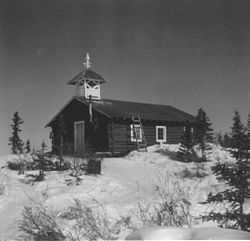
| 7 |
Mission Church |
|
01977-04-11-0000April 11, 1977
(#77001578) |
Eastern fork of Chandalar River
68°07′32″N 145°20′25″W / 68.125556°N 145.340278°W / 68.125556; -145.340278 (Mission Church) |
Arctic Village |
|
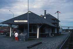
| 8 |
Nenana Depot |
|
01977-08-10-0000August 10, 1977
(#77000229) |
A St.
64°33′52″N 149°06′02″W / 64.564444°N 149.100556°W / 64.564444; -149.100556 (Nenana Depot) |
Nenana |
|
| 9 |
Old Mission House |
Upload image |
01978-11-07-0000November 7, 1978
(#78000539) |
Ft. Yukon
66°34′05″N 145°16′24″W / 66.568056°N 145.273333°W / 66.568056; -145.273333 (Old Mission House) |
Fort Yukon |
|
| 10 |
Presentation of Our Lord Chapel |
|
01980-06-06-0000June 6, 1980
(#80004584) |
In Nikolai
62°58′03″N 154°09′42″W / 62.9675°N 154.161667°W / 62.9675; -154.161667 (Presentation of Our Lord Chapel) |
Nikolai |
|
| 11 |
Ruby Roadhouse |
Upload image |
01982-05-20-0000May 20, 1982
(#82004898) |
Olson St.
64°44′25″N 155°29′25″W / 64.740278°N 155.490278°W / 64.740278; -155.490278 (Ruby Roadhouse) |
Ruby |
|
| 12 |
Frank Slaven Roadhouse |
|
01987-07-20-0000July 20, 1987
(#87001202) |
Left bank of the Yukon River ¼ mile from the mouth of Coal Creek
65°20′40″N 143°07′35″W / 65.344444°N 143.126389°W / 65.344444; -143.126389 (Frank Slaven Roadhouse) |
Eagle |
|
| 13 |
Sourdough Inn |
Upload image |
01997-12-30-0000December 30, 1997
(#97001585) |
Junction of 1st and Sled Sts.
66°33′49″N 145°16′06″W / 66.563611°N 145.268333°W / 66.563611; -145.268333 (Sourdough Inn) |
Fort Yukon |
|
| 14 |
Tanana Mission |
|
01977-08-03-0000August 3, 1977
(#77000230) |
East of Tanana
65°10′18″N 152°02′17″W / 65.171667°N 152.038056°W / 65.171667; -152.038056 (Tanana Mission) |
Tanana |
|
| 15 |
Teklanika Archeological District |
Upload image |
01976-01-31-0000January 31, 1976
(#76000171) |
On a knoll overlooking the Teklanika River[6]
63°40′35″N 149°45′20″W / 63.6764°N 149.7556°W / 63.6764; -149.7556 (Teklanika Archeological District) |
Toklat |
|
| 16 |
Tolovana Roadhouse |
|
01988-10-07-0000October 7, 1988
(#88000402) |
Sled Rd.
64°50′52″N 149°48′18″W / 64.847778°N 149.805°W / 64.847778; -149.805 (Tolovana Roadhouse) |
Nenana |
|
| 17 |
Woodchopper Roadhouse |
|
01987-07-20-0000July 20, 1987
(#87001201) |
Left bank of the Yukon River 1 mile up from Woodchopper Creek
65°20′58″N 143°17′56″W / 65.349444°N 143.298889°W / 65.349444; -143.298889 (Woodchopper Roadhouse) |
Eagle |
|
Former listings
| [3] |
Name on the Register |
Image |
Date listed | Date removed |
Location |
City or town |
Summary |
|---|
| 1 |
Mine Safety Car 5 |
Upload image |
01977-09-15-0000September 15, 1977
(#77000228) | Unknown |
E of Healy at Usibelli-Suntrana Spur 99787
|
Healy vicinity |
|
| 2 |
James Taylor Cabins |
Upload image |
01987-07-20-0000July 20, 1987
(#87001203) | 02000-08-07-0000August 7, 2000 |
Right bank of the Yukon opposite Fourth of July Creek
|
Eagle vicinity |
|
See also
References
- ↑ The latitude and longitude information provided in this table was derived originally from the National Register Information System, which has been found to be fairly accurate for about 99% of listings. For about 1% of NRIS original coordinates, experience has shown that one or both coordinates are typos or otherwise extremely far off; some corrections may have been made. A more subtle problem causes many locations to be off by up to 150 yards, depending on location in the country: most NRIS coordinates were derived from tracing out latitude and longitudes off of USGS topographical quadrant maps created under the North American Datum of 1927, which differs from the current, highly accurate WGS84 GPS system used by most on-line maps. Chicago is about right, but NRIS longitudes in Washington are higher by about 4.5 seconds, and are lower by about 2.0 seconds in Maine. Latitudes differ by about 1.0 second in Florida. Some locations in this table may have been corrected to current GPS standards.
- ↑ "National Register of Historic Places: Weekly List Actions". National Park Service, United States Department of the Interior. Retrieved on May 1, 2015.
- ↑ 3.0 3.1 Numbers represent an ordering by significant words. Various colorings, defined here, differentiate National Historic Landmarks and historic districts from other NRHP buildings, structures, sites or objects.
- ↑ "National Register Information System". National Register of Historic Places. National Park Service. 2008-04-24.
- ↑ The eight-digit number below each date is the number assigned to each location in the National Register Information System database, which can be viewed by clicking the number.
- ↑ Location derived from West, Frederick H. "Teklanika West" in American Beginnings: The Prehistory and Palaeoecology of Beringia, Frank Hadleigh West, ed. Chicago: U of Chicago P, 1996, 332. The NRIS lists the site as "Address Restricted".
|
|---|
| | Topics | |
|---|
| | Lists by states | |
|---|
| | Lists by insular areas | |
|---|
| | Lists by associated states | |
|---|
| | Other areas | |
|---|
|
-
 Category Category
-
 Portal Portal
-
 WikiProject WikiProject
|
|
|
|---|
| | Boroughs | | | | | Census areas | | | | There are no sites listed on the National Register of Historic Places in Wade Hampton Census Area |
|
.jpg)