National Register of Historic Places listings in Wood County, Ohio
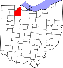
Location of Wood County in Ohio
This is a list of the National Register of Historic Places listings in Wood County, Ohio.
This is intended to be a complete list of the properties and districts on the National Register of Historic Places in Wood County, Ohio, United States. The locations of National Register properties and districts for which the latitude and longitude coordinates are included below, may be seen in a Google map.[1]
There are 31 properties and districts listed on the National Register in the county, including 1 National Historic Landmark.
- This National Park Service list is complete through NPS recent listings posted May 1, 2015.[2]
Current listings
| [3] | Name on the Register[4] | Image | Date listed[5] | Location | City or town | Description |
|---|---|---|---|---|---|---|
| 1 | Boom Town Historic District |  |
(#87000693) |
Roughly bounded by W. Wooster, S. Church, N. Grove, N. Maple, and Buttonwood 41°22′24″N 83°39′20″W / 41.373333°N 83.655556°W |
Bowling Green | |
| 2 | Dodge Site |  |
(#78002214) |
17090 W. River Rd., north of Bowling Green[6] 41°29′00″N 83°43′46″W / 41.483333°N 83.729444°W |
Middleton Township | |
| 3 | Eagle Point Colony Historic District | Upload image | (#83002068) |
Colony Rd., Riverside, Eagle Point, Park, and Forest Drs. 41°36′32″N 83°34′20″W / 41.608889°N 83.572222°W |
Rossford | |
| 4 | East River Road Historic District I |  |
(#76001551) |
29455-30465 E. River Rd. (northern side only), southwest of Rossford 41°35′11″N 83°35′27″W / 41.586389°N 83.590833°W |
Perrysburg Township | |
| 5 | East River Road Historic District II |  |
(#76001550) |
577 E. Front St. to 28589 E. River Rd. 41°34′00″N 83°37′05″W / 41.566667°N 83.618056°W |
Perrysburg and Perrysburg Township | |
| 6 | Empire House | 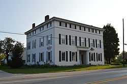 |
(#78002216) |
5535 U.S. Route 20, east of Stony Ridge 41°30′29″N 83°30′11″W / 41.507917°N 83.503194°W |
Troy Township | |
| 7 | Floral Hall | 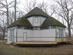 |
(#82003666) |
City Park on Conneaut Ave. 41°22′49″N 83°39′32″W / 41.380139°N 83.658889°W |
Bowling Green | |
| 8 | Fort Meigs | 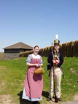 |
(#69000151) |
1.3 mi (2.1 km) southwest of Perrysburg 41°33′10″N 83°39′06″W / 41.552778°N 83.651667°W |
Perrysburg | |
| 9 | Fort Meigs Aboriginal-33WO08-33WO445 | 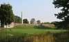 |
(#98000042) |
1.3 mi (2.1 km) southwest of Perrysburg 41°33′10″N 83°39′04″W / 41.552778°N 83.651111°W |
Perrysburg | |
| 10 | William Graham House | 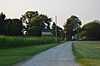 |
(#84003812) |
7056 Jerry City Rd., southwest of Wayne 41°15′17″N 83°32′18″W / 41.254722°N 83.538333°W |
Portage Township | |
| 11 | Heeter-Russo House | Upload image | (#75001554) |
24570 2nd St. 41°24′37″N 83°52′27″W / 41.410278°N 83.874167°W |
Grand Rapids | |
| 12 | Hood-Simmons House | 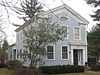 |
(#74001652) |
202 W. 5th St. 41°33′17″N 83°37′46″W / 41.554861°N 83.629444°W |
Perrysburg | |
| 13 | R.A. Housley House | Upload image | (#96000932) |
24155 Front St. 41°24′45″N 83°51′55″W / 41.4125°N 83.865278°W |
Grand Rapids | |
| 14 | Indian Hills Site | 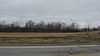 |
(#79001983) |
Atop a promontory above the final bend of Grassy Creek, east of its confluence with the Maumee River[7] 41°36′24″N 83°33′12″W / 41.606667°N 83.553333°W |
Rossford | |
| 15 | Interurban Bridge | 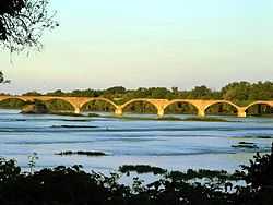 |
(#72001036) |
1 mi (1.6 km) south of Waterville over the Maumee River 41°29′11″N 83°43′42″W / 41.486389°N 83.728333°W |
Middleton Township | Extends into Lucas County |
| 16 | Benjamin F. Kerr House | Upload image | (#79001982) |
17605 Beaver St. 41°24′37″N 83°52′05″W / 41.410278°N 83.868056°W |
Grand Rapids | |
| 17 | MacNichol Site | 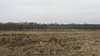 |
(#78002215) |
Southwest of Perrysburg along the Maumee River[8] 41°32′53″N 83°40′02″W / 41.548056°N 83.667222°W |
Perrysburg Township | |
| 18 | Main Street Historic District | 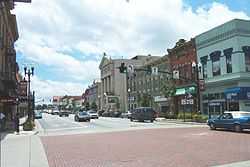 |
(#80003247) |
Main and Wooster Sts. 41°22′30″N 83°39′02″W / 41.375°N 83.650556°W |
Bowling Green | |
| 19 | North Baltimore Town Hall | 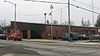 |
(#81000453) |
207 North Main St. 41°10′59″N 83°40′43″W / 41.183056°N 83.678611°W |
North Baltimore | Destroyed in 1985[9] |
| 20 | Old Wood County Jail | 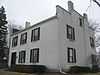 |
(#69000152) |
240 W. Indiana Ave. 41°33′20″N 83°37′54″W / 41.555417°N 83.631528°W |
Perrysburg | |
| 21 | Perrysburg Historic District | 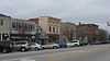 |
(#75001557) |
Front St. between E. Boundary St. and W. Boundary Ln., 2nd St. between Pine and Hickory Sts., and 3rd St. at Louisiana Ave.; also roughly the Maumee River frontage from Pine to E. Boundary and the southern side of E. 2nd St. from Locust to Hickory 41°33′36″N 83°37′48″W / 41.560000°N 83.630000°W |
Perrysburg | Second set of addresses represents a boundary increase of June 21, 1990 |
| 22 | Perrysburg Water Maintenance Building | 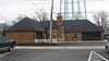 |
(#90000754) |
130 W. Indiana Ave. 41°33′21″N 83°37′44″W / 41.555833°N 83.628889°W |
Perrysburg | |
| 23 | Schaller Memorial Building | 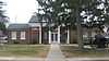 |
(#90000753) |
130 W. Indiana Ave. 41°33′20″N 83°37′44″W / 41.555611°N 83.628889°W |
Perrysburg | |
| 24 | Edwin H. Simmons House | Upload image | (#90002211) |
10302 Fremont Pike, southeast of Perrysburg 41°32′45″N 83°35′32″W / 41.545833°N 83.592222°W |
Perrysburg Township | |
| 25 | Spafford House | 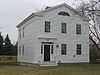 |
(#74001653) |
27338 W. River Rd. 41°32′57″N 83°39′25″W / 41.549028°N 83.656806°W |
Perrysburg | |
| 26 | Thurston Building | Upload image | (#75001555) |
Front St. 41°24′43″N 83°52′03″W / 41.411944°N 83.8675°W |
Grand Rapids | |
| 27 | Town Hall | Upload image | (#75001556) |
Front St. 41°24′44″N 83°52′08″W / 41.412222°N 83.868889°W |
Grand Rapids | |
| 28 | U.S. Post Office | 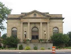 |
(#79001980) |
305 N. Main St. 41°22′38″N 83°39′06″W / 41.377222°N 83.651667°W |
Bowling Green | |
| 29 | Wood County Courthouse and Jail | 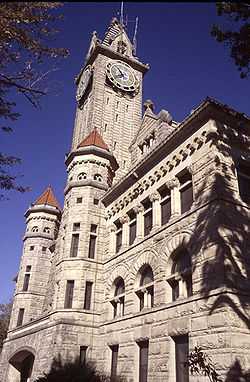 |
(#74001651) |
200 E. Court St. 41°22′35″N 83°38′54″W / 41.376389°N 83.648333°W |
Bowling Green | |
| 30 | Wood County Home and Infirmary | 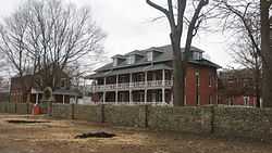 |
(#79001981) |
Southeast of Bowling Green at 13660 County Home Rd. 41°21′02″N 83°37′01″W / 41.350556°N 83.616944°W |
Portage Township | |
| 31 | John J. Yeager House | 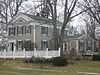 |
(#85000619) |
343 W. Indiana Ave. 41°33′19″N 83°38′02″W / 41.555139°N 83.633889°W |
Perrysburg |
See also
| Wikimedia Commons has media related to National Register of Historic Places in Wood County, Ohio. |
References
- ↑ The latitude and longitude information provided in this table was derived originally from the National Register Information System, which has been found to be fairly accurate for about 99% of listings. For about 1% of NRIS original coordinates, experience has shown that one or both coordinates are typos or otherwise extremely far off; some corrections may have been made. A more subtle problem causes many locations to be off by up to 150 yards, depending on location in the country: most NRIS coordinates were derived from tracing out latitude and longitudes off of USGS topographical quadrant maps created under the North American Datum of 1927, which differs from the current, highly accurate WGS84 GPS system used by most on-line maps. Chicago is about right, but NRIS longitudes in Washington are higher by about 4.5 seconds, and are lower by about 2.0 seconds in Maine. Latitudes differ by about 1.0 second in Florida. Some locations in this table may have been corrected to current GPS standards.
- ↑ "National Register of Historic Places: Weekly List Actions". National Park Service, United States Department of the Interior. Retrieved on May 1, 2015.
- ↑ Numbers represent an ordering by significant words. Various colorings, defined here, differentiate National Historic Landmarks and historic districts from other NRHP buildings, structures, sites or objects.
- ↑ "National Register Information System". National Register of Historic Places. National Park Service. 2008-04-24.
- ↑ The eight-digit number below each date is the number assigned to each location in the National Register Information System database, which can be viewed by clicking the number.
- ↑ Ohio Historic Preservation Office: Northwest Ohio Office - MS 817, Bowling Green State University Libraries, n.d. Accessed 2013-01-02.
- ↑ Strothers, David M. "Indian Hills (33W04): A Protohistoric Assistaeronon Village in the Maumee River Valley of Northwestern Ohio". Ontario Archaeology 36 (1981): 47-56, p. 48.
- ↑ Strothers, David M., and G. Michael Pratt. "New Perspectives on the Late Woodland Cultures of the Western Lake Erie Region". Midcontinental Journal of Archaeology 6.1 (1981): 91-121.
- ↑ HISTORY - Village of North Baltimore, Village of North Baltimore, n.d. Accessed 2013-03-11.


| |||||||||||||||||||||||||||||||||