| [3] |
Name on the Register |
Image |
Date listed[4] |
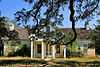
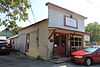
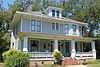
Location |
City or town |
Description |
|---|
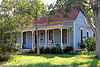
| 1 |
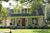
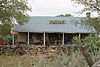
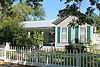
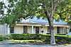
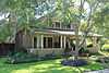
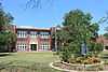
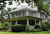
Martin C. Amos House |
|
01986-04-29-0000April 29, 1986
(#86000989) |
1408 Olive
30°37′53″N 97°40′01″W / 30.631389°N 97.666944°W / 30.631389; -97.666944 (Martin C. Amos House) |
Georgetown |
|
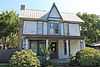
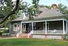
| 2 |
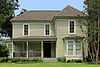
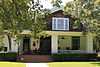
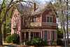
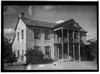
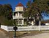
Arnold-Torbet House |
|
01986-04-29-0000April 29, 1986
(#86000990) |
908 Pine
30°38′07″N 97°40′13″W / 30.6353°N 97.6702°W / 30.6353; -97.6702 (Arnold-Torbet House) |
Georgetown |
|
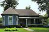
| 3 |
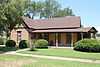
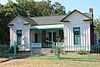
Atkinson House |
Upload image |
01986-04-29-0000April 29, 1986
(#86000992) |
911 Walnut
30°38′08″N 97°40′13″W / 30.635556°N 97.670278°W / 30.635556; -97.670278 (Atkinson House) |
Georgetown |
|
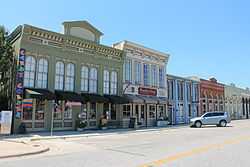
| 4 |
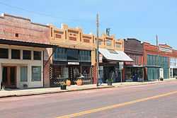
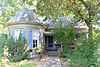
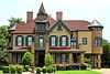
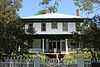
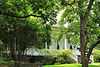
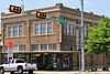
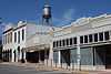
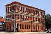
Bartlett Commercial Historic District |
|
01980-09-30-0000September 30, 1980
(#80004076) |
E. Clark St.
30°47′42″N 97°25′37″W / 30.795°N 97.426944°W / 30.795; -97.426944 (Bartlett Commercial Historic District) |
Bartlett |
|
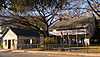
| 5 |
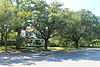
Belford Historic District |
|
01986-04-29-0000April 29, 1986
(#86000991) |
Roughly bounded by University Ave., Main, E. Eighteenth, and Austin
30°37′48″N 97°40′39″W / 30.63°N 97.6775°W / 30.63; -97.6775 (Belford Historic District) |
Georgetown |
|
| 6 |
Bowlen House |
Upload image |
01986-01-14-0000January 14, 1986
(#86000180) |
1405 Forest
30°37′53″N 97°40′44″W / 30.631389°N 97.678889°W / 30.631389; -97.678889 (Bowlen House) |
Georgetown |
|
| 7 |
Bryson Stage Coach Stop |
|
01978-12-01-0000December 1, 1978
(#78003000) |
Northwest of Liberty Hill on TX 29
30°40′40″N 97°56′37″W / 30.677778°N 97.943611°W / 30.677778; -97.943611 (Bryson Stage Coach Stop) |
Liberty Hill |
|
| 8 |
Burcham House |
|
01986-04-29-0000April 29, 1986
(#86000993) |
1310 College
30°37′54″N 97°40′19″W / 30.631667°N 97.671944°W / 30.631667; -97.671944 (Burcham House) |
Georgetown |
|
| 9 |
Casey House |
Upload image |
01986-01-14-0000January 14, 1986
(#86000184) |
705 E. Third
30°38′27″N 97°40′12″W / 30.640833°N 97.67°W / 30.640833; -97.67 (Casey House) |
Georgetown |
|
| 10 |
Caswell House |
|
01986-04-29-0000April 29, 1986
(#86000994) |
207 E. Ninth
30°38′09″N 97°40′31″W / 30.635833°N 97.675278°W / 30.635833; -97.675278 (Caswell House) |
Georgetown |
|
| 11 |
Chesser-Morgan House |
|
01986-01-14-0000January 14, 1986
(#86000185) |
1202 E. Fifteenth
30°37′49″N 97°39′56″W / 30.630278°N 97.665556°W / 30.630278; -97.665556 (Chesser-Morgan House) |
Georgetown |
|
| 12 |
Jesse and Sara Cooper House |
Upload image |
01996-02-16-0000February 16, 1996
(#96000073) |
1.8 mi (2.9 km). east of Georgetown Hwy. 29
30°38′32″N 97°38′48″W / 30.642222°N 97.646667°W / 30.642222; -97.646667 (Jesse and Sara Cooper House) |
Georgetown |
|
| 13 |
E. M. Daughtrey House |
Upload image |
01986-04-29-0000April 29, 1986
(#86000984) |
1316 E. University
30°37′58″N 97°39′47″W / 30.632778°N 97.663056°W / 30.632778; -97.663056 (E. M. Daughtrey House) |
Georgetown |
|
| 14 |
John J. Dimmitt House |
|
01996-02-16-0000February 16, 1996
(#96000076) |
W. University (TX 29) 0.5 mi. west of the junction with Austin Highway.
30°38′05″N 97°41′12″W / 30.6347°N 97.6867°W / 30.6347; -97.6867 (John J. Dimmitt House) |
Georgetown |
|
| 15 |
S. A. Easley House |
|
01986-04-29-0000April 29, 1986
(#86000983) |
1310 Olive
30°37′55″N 97°40′02″W / 30.6319°N 97.6673°W / 30.6319; -97.6673 (S. A. Easley House) |
Georgetown |
|
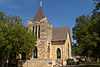
| 16 |
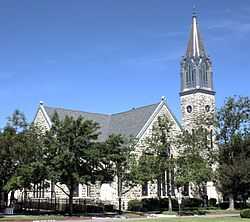
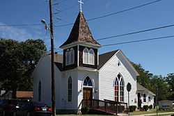
First Methodist Church |
|
01986-06-17-0000June 17, 1986
(#86001368) |
410 E. University
30°37′58″N 97°40′23″W / 30.632778°N 97.673056°W / 30.632778; -97.673056 (First Methodist Church) |
Georgetown |
|
| 17 |
D. D. Fowler House |
|
01986-04-29-0000April 29, 1986
(#86000985) |
1531 Ash
30°37′45″N 97°40′21″W / 30.629167°N 97.6725°W / 30.629167; -97.6725 (D. D. Fowler House) |
Georgetown |
|
| 18 |
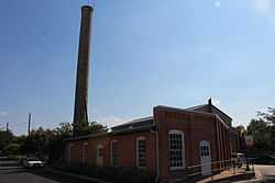
Georgetown Light and Water Works |
|
01996-02-16-0000February 16, 1996
(#96000074) |
403 W. 9th
30°38′10″N 97°40′49″W / 30.636111°N 97.680278°W / 30.636111; -97.680278 (Georgetown Light and Water Works) |
Georgetown |
|
| 19 |
Harper-Chesser House |
|
01986-04-29-0000April 29, 1986
(#86000969) |
1309 College
30°37′54″N 97°40′17″W / 30.631667°N 97.671389°W / 30.631667; -97.671389 (Harper-Chesser House) |
Georgetown |
|
| 20 |
Moses Harrell House |
|
01986-01-14-0000January 14, 1986
(#86000169) |
1001 Church
30°38′04″N 97°40′32″W / 30.634444°N 97.675556°W / 30.634444; -97.675556 (Moses Harrell House) |
Georgetown |
|
| 21 |
E. M. Harris House |
|
01986-01-14-0000January 14, 1986
(#86000168) |
404 E. Seventh
30°38′13″N 97°40′24″W / 30.636944°N 97.673333°W / 30.636944; -97.673333 (E. M. Harris House) |
Georgetown |
|
| 22 |
A. W. Hawnen House |
|
01986-04-29-0000April 29, 1986
(#86000967) |
1409 Olive
30°37′54″N 97°39′59″W / 30.631667°N 97.666389°W / 30.631667; -97.666389 (A. W. Hawnen House) |
Georgetown |
|
| 23 |
M. S. Hewitt House |
Upload image |
01996-02-16-0000February 16, 1996
(#96000071) |
1019 S. College
30°38′01″N 97°40′24″W / 30.633611°N 97.673333°W / 30.633611; -97.673333 (M. S. Hewitt House) |
Georgetown |
|
| 24 |
House at 214 W. University |
|
01986-04-29-0000April 29, 1986
(#86000987) |
214 W. University
30°37′58″N 97°40′41″W / 30.632778°N 97.678056°W / 30.632778; -97.678056 (House at 214 W. University) |
Georgetown |
|
| 25 |
House at 801 West |
Upload image |
01986-01-14-0000January 14, 1986
(#86000172) |
801 West
30°38′10″N 97°40′52″W / 30.636111°N 97.681111°W / 30.636111; -97.681111 (House at 801 West) |
Georgetown |
|
| 26 |
House at 907 Pine |
|
01986-01-14-0000January 14, 1986
(#86000171) |
907 Pine
30°38′09″N 97°40′11″W / 30.6359°N 97.6697°W / 30.6359; -97.6697 (House at 907 Pine) |
Georgetown |
|
| 27 |
Hutto Commercial Historic District |
|
02011-08-04-0000August 4, 2011
(#11000515) |
101-205 East St., 202 Farley St. & 204 US 79
30°32′38″N 97°31′50″W / 30.543889°N 97.530556°W / 30.543889; -97.530556 (Hutto Commercial Historic District) |
Hutto |
|
| 28 |
Dr. Robert Hyer House |
Upload image |
01986-01-14-0000January 14, 1986
(#86000175) |
904 Ash
30°38′07″N 97°40′23″W / 30.635278°N 97.673056°W / 30.635278; -97.673056 (Dr. Robert Hyer House) |
Georgetown |
|
| 29 |
Imhoff House |
Upload image |
01986-01-14-0000January 14, 1986
(#86000176) |
208 Austin
30°38′27″N 97°40′41″W / 30.640833°N 97.678056°W / 30.640833; -97.678056 (Imhoff House) |
Georgetown |
|
| 30 |
Inn at Brushy Creek |
|
01970-10-15-0000October 15, 1970
(#70000777) |
Taylor Exit off U.S. 79, off I-35
30°30′57″N 97°41′22″W / 30.5159°N 97.6894°W / 30.5159; -97.6894 (Inn at Brushy Creek) |
Round Rock |
|
| 31 |
George Irvine House |
|
01986-04-29-0000April 29, 1986
(#86000973) |
409 E. University
30°38′00″N 97°40′24″W / 30.633333°N 97.673333°W / 30.633333; -97.673333 (George Irvine House) |
Georgetown |
|
| 32 |
J. J. Johnson Farm |
Upload image |
01986-01-14-0000January 14, 1986
(#86000178) |
Rabbitt Hill Rd.
30°34′59″N 97°40′18″W / 30.583056°N 97.671667°W / 30.583056; -97.671667 (J. J. Johnson Farm) |
Georgetown |
|
| 33 |
Kenney's Fort Site (41WM465) |
Upload image |
01987-04-20-0000April 20, 1987
(#87000565) |
Address Restricted
|
Round Rock |
|
| 34 |
Lane-Riley House |
|
01986-04-29-0000April 29, 1986
(#86000975) |
1302 College
30°37′55″N 97°40′19″W / 30.631944°N 97.671944°W / 30.631944; -97.671944 (Lane-Riley House) |
Georgetown |
|
| 35 |
Will and Mary Leake House |
Upload image |
01986-04-29-0000April 29, 1986
(#86000976) |
313 E. Seventh
30°38′14″N 97°40′26″W / 30.637222°N 97.673889°W / 30.637222; -97.673889 (Will and Mary Leake House) |
Georgetown |
|
| 36 |
John Leavell House |
|
01986-04-29-0000April 29, 1986
(#86000979) |
803 College
30°38′12″N 97°40′18″W / 30.636653°N 97.671552°W / 30.636653; -97.671552 (John Leavell House) |
Georgetown |
|
| 37 |
M. B. and Annie Lockett House |
Upload image |
01986-04-29-0000April 29, 1986
(#86000981) |
811 E. University
30°38′00″N 97°40′08″W / 30.633333°N 97.668889°W / 30.633333; -97.668889 (M. B. and Annie Lockett House) |
Georgetown |
|
| 38 |
Frank and Mellie Love House |
|
01986-04-29-0000April 29, 1986
(#86000977) |
1415 Ash
30°37′50″N 97°40′20″W / 30.630556°N 97.672222°W / 30.630556; -97.672222 (Frank and Mellie Love House) |
Georgetown |
|
| 39 |
W. K. and Kate Makemson House |
Upload image |
01986-01-14-0000January 14, 1986
(#86000190) |
1002 Ash
30°38′04″N 97°40′23″W / 30.634444°N 97.673056°W / 30.634444; -97.673056 (W. K. and Kate Makemson House) |
Georgetown |
|
| 40 |
McFadin House |
|
01980-04-09-0000April 9, 1980
(#80004160) |
North of Taylor
30°38′18″N 97°25′33″W / 30.638333°N 97.425833°W / 30.638333; -97.425833 (McFadin House) |
Taylor |
|
| 41 |
McKnight-Ebb House |
Upload image |
01986-01-14-0000January 14, 1986
(#86000191) |
502 W. Eighteenth
30°37′34″N 97°40′53″W / 30.626111°N 97.681389°W / 30.626111; -97.681389 (McKnight-Ebb House) |
Georgetown |
|
| 42 |
McMurray House |
Upload image |
01986-01-14-0000January 14, 1986
(#86000192) |
611 Church
30°38′13″N 97°40′30″W / 30.636944°N 97.675°W / 30.636944; -97.675 (McMurray House) |
Georgetown |
|
| 43 |
Capt. Nelson Merrell House |
|
01970-10-15-0000October 15, 1970
(#70000778) |
Northeast of Round Rock on U.S. 79
30°31′02″N 97°39′41″W / 30.517222°N 97.661389°W / 30.517222; -97.661389 (Capt. Nelson Merrell House) |
Round Rock |
|
| 44 |
Miller-Ellyson House |
|
01986-01-14-0000January 14, 1986
(#86000193) |
303 E. Ninth
30°38′09″N 97°40′28″W / 30.635833°N 97.674444°W / 30.635833; -97.674444 (Miller-Ellyson House) |
Georgetown |
|
| 45 |
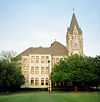
Old Georgetown High School |
|
01986-01-14-0000January 14, 1986
(#86000195) |
507 E. University
30°38′01″N 97°40′20″W / 30.633611°N 97.672222°W / 30.633611; -97.672222 (Old Georgetown High School) |
Georgetown |
|
| 46 |
Olive Street Historic District |
Upload image |
02013-08-20-0000August 20, 2013
(#13000615) |
Olive St. between E. University Ave. & 17th St. plus a portion of E. 15th St.
30°37′51″N 97°40′01″W / 30.63084°N 97.6670°W / 30.63084; -97.6670 (Olive Street Historic District) |
Georgetown |
|
| 47 |
Paige-DeCrow-Weir House |
|
01986-01-14-0000January 14, 1986
(#86000194) |
I-35 and State Route 2243
30°37′24″N 97°41′30″W / 30.623333°N 97.691667°W / 30.623333; -97.691667 (Paige-DeCrow-Weir House) |
Georgetown |
|
| 48 |
Woodson and Margaret Patrick House |
|
01986-01-14-0000January 14, 1986
(#86000197) |
211 E. Fifth
30°38′21″N 97°40′31″W / 30.639167°N 97.675278°W / 30.639167; -97.675278 (Woodson and Margaret Patrick House) |
Georgetown |
|
| 49 |
Pegues House |
|
01986-01-14-0000January 14, 1986
(#86000196) |
904 E. University
30°37′59″N 97°40′07″W / 30.6330°N 97.6687°W / 30.6330; -97.6687 (Pegues House) |
Georgetown |
|
| 50 |
Preslar-Hewitt Building |
|
02003-05-01-0000May 1, 2003
(#03000331) |
321-323 N. Main
30°34′13″N 97°24′35″W / 30.570278°N 97.409722°W / 30.570278; -97.409722 (Preslar-Hewitt Building) |
Taylor |
|
| 51 |
R. H. and Martha Price House |
|
01986-04-29-0000April 29, 1986
(#86000982) |
209 E. Tenth
30°38′05″N 97°40′31″W / 30.634722°N 97.675278°W / 30.634722; -97.675278 (R. H. and Martha Price House) |
Georgetown |
|
| 52 |
Railroad Produce Depot |
|
01979-11-07-0000November 7, 1979
(#79003024) |
401 W. 6th St.
30°38′18″N 97°40′49″W / 30.638333°N 97.680278°W / 30.638333; -97.680278 (Railroad Produce Depot) |
Georgetown |
|
| 53 |
J. H. Reedy House |
|
01986-04-29-0000April 29, 1986
(#86000949) |
908 E. University
30°37′59″N 97°40′06″W / 30.6330°N 97.6682°W / 30.6330; -97.6682 (J. H. Reedy House) |
Georgetown |
|
| 54 |
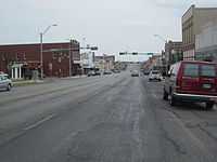
Round Rock Commercial Historic District |
|
01983-06-09-0000June 9, 1983
(#83003170) |
100 and 200 blocks of E. Main St.
30°30′30″N 97°40′39″W / 30.508333°N 97.6775°W / 30.508333; -97.6775 (Round Rock Commercial Historic District) |
Round Rock |
|
| 55 |
Round Rock Post Office and William M. Owen House |
|
01983-07-07-0000July 7, 1983
(#83003171) |
Chisholm Trail and Emanuel St.
30°30′55″N 97°41′24″W / 30.515278°N 97.69°W / 30.515278; -97.69 (Round Rock Post Office and William M. Owen House) |
Round Rock |
|
| 56 |
Rouser House |
|
01986-01-14-0000January 14, 1986
(#86000198) |
602 Myrtle
30°38′16″N 97°40′30″W / 30.637778°N 97.675°W / 30.637778; -97.675 (Rouser House) |
Georgetown |
|
| 57 |
Saint John's Methodist Church |
|
01986-04-29-0000April 29, 1986
(#86000950) |
301 E University Ave
30°38′01″N 97°40′29″W / 30.633611°N 97.674722°W / 30.633611; -97.674722 (Saint John's Methodist Church) |
Georgetown |
|
| 58 |
Sansom-Schmalenbeck House |
Upload image |
01986-01-14-0000January 14, 1986
(#86000199) |
813 Church
30°38′09″N 97°40′32″W / 30.635833°N 97.675556°W / 30.635833; -97.675556 (Sansom-Schmalenbeck House) |
Georgetown |
|
| 59 |
Saxon Motor Car Store |
|
01986-06-17-0000June 17, 1986
(#86001366) |
316 E. Sixth St.
30°38′17″N 97°40′27″W / 30.638056°N 97.674167°W / 30.638056; -97.674167 (Saxon Motor Car Store) |
Georgetown |
|
| 60 |
A. W. Sillure House |
|
01986-04-29-0000April 29, 1986
(#86000951) |
1414 Ash
30°37′50″N 97°40′23″W / 30.630556°N 97.673056°W / 30.630556; -97.673056 (A. W. Sillure House) |
Georgetown |
|
| 61 |
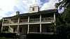
Southwestern University Administration Building and Mood Hall |
|
01975-04-23-0000April 23, 1975
(#75002013) |
University Ave., Southwestern University campus
30°38′00″N 97°40′01″W / 30.633333°N 97.666944°W / 30.633333; -97.666944 (Southwestern University Administration Building and Mood Hall) |
Georgetown |
|
| 62 |
Robert and Lula Stone House |
Upload image |
01986-01-14-0000January 14, 1986
(#86000200) |
1102 Ash
30°38′01″N 97°40′23″W / 30.633611°N 97.673056°W / 30.633611; -97.673056 (Robert and Lula Stone House) |
Georgetown |
|
| 63 |
Taylor Downtown Historic District |
|
02005-10-26-0000October 26, 2005
(#05001193) |
Roughly bounded by 5th, Washburn, 1st & Vance Sts.
30°34′16″N 97°24′36″W / 30.571111°N 97.41°W / 30.571111; -97.41 (Taylor Downtown Historic District) |
Taylor |
|
| 64 |
Taylor National Bank |
|
01980-05-23-0000May 23, 1980
(#80004159) |
200 Main St.
30°34′07″N 97°24′33″W / 30.568611°N 97.409167°W / 30.568611; -97.409167 (Taylor National Bank) |
Taylor |
|
| 65 |
Taylor-Cooper House |
|
01986-01-14-0000January 14, 1986
(#86000203) |
105 E 5th
30°38′22″N 97°40′36″W / 30.639444°N 97.676667°W / 30.639444; -97.676667 (Taylor-Cooper House) |
Georgetown |
|
| 66 |
Tinnen House |
|
01970-08-25-0000August 25, 1970
(#70000776) |
1220 Austin St.
30°37′53″N 97°40′37″W / 30.631389°N 97.676944°W / 30.631389; -97.676944 (Tinnen House) |
Georgetown |
|
| 67 |
University Avenue-Elm Street Historic District |
Upload image |
01979-12-06-0000December 6, 1979
(#79003025) |
E. University and Elm Sts.
30°37′44″N 97°40′18″W / 30.628889°N 97.671667°W / 30.628889; -97.671667 (University Avenue-Elm Street Historic District) |
Georgetown |
|
| 68 |
W. C. and Kate Vaden House |
|
01986-04-29-0000April 29, 1986
(#86000952) |
711 E. University
30°38′01″N 97°40′13″W / 30.63358°N 97.67024°W / 30.63358; -97.67024 (W. C. and Kate Vaden House) |
Georgetown |
|
| 69 |
Wesley Chapel A.M.E Church |
|
01986-01-14-0000January 14, 1986
(#86000204) |
508 W. Fourth
30°38′24″N 97°40′53″W / 30.64°N 97.681389°W / 30.64; -97.681389 (Wesley Chapel A.M.E Church) |
Georgetown |
|
| 70 |
D. K. and Inez Wilcox House |
|
01986-04-29-0000April 29, 1986
(#86000954) |
1307 Olive
30°37′55″N 97°40′00″W / 30.6319°N 97.6667°W / 30.6319; -97.6667 (D. K. and Inez Wilcox House) |
Georgetown |
|
| 71 |
Wilcox-Graves House |
|
01986-04-29-0000April 29, 1986
(#86000953) |
1403 Olive
30°37′55″N 97°39′59″W / 30.631944°N 97.666389°W / 30.631944; -97.666389 (Wilcox-Graves House) |
Georgetown |
|
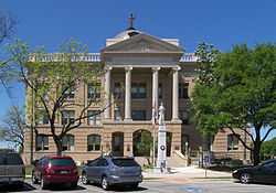
| 72 |
Williamson County Courthouse Historical District |
|
01977-07-26-0000July 26, 1977
(#77001480) |
Rock and 9th Sts., Main and 7th Sts. (includes both sides)
30°38′12″N 97°40′39″W / 30.636667°N 97.6775°W / 30.636667; -97.6775 (Williamson County Courthouse Historical District) |
Georgetown |
|
| 73 |
Zidell House |
|
02009-05-12-0000May 12, 2009
(#09000308) |
2015 W. Lake Dr.
30°34′33″N 97°25′53″W / 30.575811°N 97.431417°W / 30.575811; -97.431417 (Zidell House) |
Taylor |
|