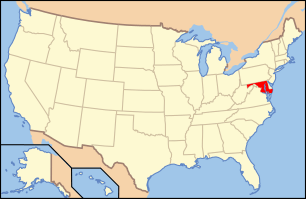
National Register of Historic Places listings in Wicomico County, Maryland
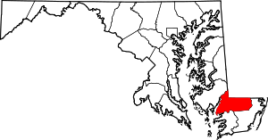
Location of Wicomico County in Maryland
This is a list of the National Register of Historic Places listings in Wicomico County, Maryland.
This is intended to be a complete list of the properties and districts on the National Register of Historic Places in Wicomico County, Maryland, United States. Latitude and longitude coordinates are provided for many National Register properties and districts; these locations may be seen together in a Google map.[1]
There are 22 properties and districts listed on the National Register in the county.
- This National Park Service list is complete through NPS recent listings posted May 1, 2015.[2]
Current listings
| [3] |
Name on the Register[4] |
Image |
Date listed[5] |
Location |
City or town |
Description |
|---|
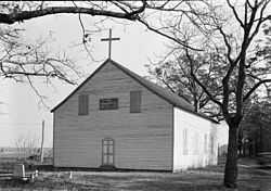
| 1 |
Asbury Methodist Episcopal Church |
Upload image |
01999-08-27-0000August 27, 1999
(#99001041) |
26679 Collins Wharf Rd.
38°17′25″N 75°41′26″W / 38.290278°N 75.690556°W / 38.290278; -75.690556 (Asbury Methodist Episcopal Church) |
Allen |
|
| 2 |
Beaudley |
Upload image |
02001-12-07-0000December 7, 2001
(#01001334) |
3955 Jesterville Rd.
38°18′13″N 75°52′10″W / 38.303611°N 75.869444°W / 38.303611; -75.869444 (Beaudley) |
Tyaskin |
|
| 3 |
Bennett's Adventure |
Upload image |
01975-11-20-0000November 20, 1975
(#75000928) |
3 miles west of Allen on Clifford Cooper Rd.
38°17′02″N 75°44′05″W / 38.283889°N 75.734722°W / 38.283889; -75.734722 (Bennett's Adventure) |
Allen |
|
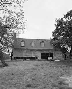
| 4 |
Bounds Lott |
|
01978-11-14-0000November 14, 1978
(#78001488) |
4146 Rivermere Lane
38°18′32″N 75°44′56″W / 38.308889°N 75.748889°W / 38.308889; -75.748889 (Bounds Lott) |
Allen |
|
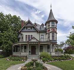
| 5 |
Gillis-Grier House |
|
01972-10-31-0000October 31, 1972
(#72000589) |
401 N. Division St.
38°22′14″N 75°35′54″W / 38.370556°N 75.598333°W / 38.370556; -75.598333 (Gillis-Grier House) |
Salisbury |
|
| 6 |
Honeysuckle Lodge |
Upload image |
01996-08-08-0000August 8, 1996
(#96000880) |
1601 Camden Ave.
38°20′06″N 75°36′53″W / 38.335°N 75.614722°W / 38.335; -75.614722 (Honeysuckle Lodge) |
Salisbury |
|
| 7 |
Sen. William P. Jackson House |
Upload image |
01976-09-28-0000September 28, 1976
(#76001022) |
514 Camden Ave.
38°21′37″N 75°36′19″W / 38.360278°N 75.605278°W / 38.360278; -75.605278 (Sen. William P. Jackson House) |
Salisbury |
Demolished in 1976[6]
|
| 8 |
Long Hill |
Upload image |
01974-12-31-0000December 31, 1974
(#74000978) |
Wetipquin Ferry Rd
38°19′32″N 75°50′07″W / 38.325556°N 75.835278°W / 38.325556; -75.835278 (Long Hill) |
Wetipquin |
|
| 9 |
Maple Leaf Farm Potato House |
Upload image |
01998-06-01-0000June 1, 1998
(#98000544) |
26632 Porter Mill Rd.
38°26′14″N 75°41′24″W / 38.437222°N 75.69°W / 38.437222; -75.69 (Maple Leaf Farm Potato House) |
Hebron |
|
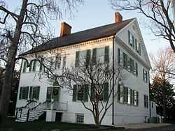
| 10 |
Pemberton Hall |
|
01971-02-18-0000February 18, 1971
(#71000379) |
Pemberton Rd.
38°20′52″N 75°38′40″W / 38.347728°N 75.644573°W / 38.347728; -75.644573 (Pemberton Hall) |
Salisbury |
|
| 11 |
Perry-Cooper House |
|
01977-11-17-0000November 17, 1977
(#77000706) |
200 E. William St.
38°22′10″N 75°35′51″W / 38.369444°N 75.5975°W / 38.369444; -75.5975 (Perry-Cooper House) |
Salisbury |
|
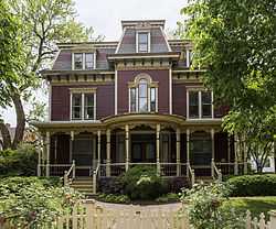
| 12 |
Poplar Hill Mansion |
|
01971-10-07-0000October 7, 1971
(#71000380) |
117 Elizabeth St.
38°22′17″N 75°35′43″W / 38.371389°N 75.595278°W / 38.371389; -75.595278 (Poplar Hill Mansion) |
Salisbury |
|
| 13 |
San Domingo School |
Upload image |
02007-02-16-0000February 16, 2007
(#07000044) |
11526 Old School Rd.
38°30′39″N 75°43′22″W / 38.510833°N 75.722778°W / 38.510833; -75.722778 (San Domingo School) |
Sharptown |
|
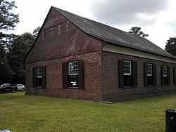
| 14 |
Spring Hill Church |
|
01976-10-22-0000October 22, 1976
(#76001021) |
1 mile northeast of Hebron at the junction of U.S. Route 50 and Maryland Route 347
38°25′46″N 75°40′25″W / 38.429444°N 75.673611°W / 38.429444; -75.673611 (Spring Hill Church) |
Hebron |
|
| 15 |
St. Bartholomew's Episcopal Church |
|
01975-06-05-0000June 5, 1975
(#75000929) |
Green Hill Church Rd.
38°17′30″N 75°47′30″W / 38.291667°N 75.791667°W / 38.291667; -75.791667 (St. Bartholomew's Episcopal Church) |
Quantico |
|
| 16 |
St. Giles |
Upload image |
01982-12-20-0000December 20, 1982
(#82001602) |
Southwest of Hebron on Maryland Route 347
38°24′50″N 75°41′57″W / 38.413889°N 75.699167°W / 38.413889; -75.699167 (St. Giles) |
Hebron |
|
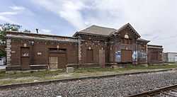
| 17 |
Union Station |
|
02007-05-02-0000May 2, 2007
(#07000389) |
611 Railroad Ave.
38°22′16″N 75°35′35″W / 38.371111°N 75.593056°W / 38.371111; -75.593056 (Union Station) |
Salisbury |
|
| 18 |
F. Leonard Wailes Law Office |
|
01997-04-14-0000April 14, 1997
(#97000314) |
116-118 E. Main St.
38°21′55″N 75°35′59″W / 38.365397°N 75.599786°W / 38.365397; -75.599786 (F. Leonard Wailes Law Office) |
Salisbury |
|
| 19 |
Western Fields |
Upload image |
01987-06-12-0000June 12, 1987
(#87000641) |
Porter Mill Rd.
38°26′05″N 75°41′23″W / 38.434722°N 75.689722°W / 38.434722; -75.689722 (Western Fields) |
Hebron |
|
| 20 |
Whitehaven Historic District |
|
01980-01-09-0000January 9, 1980
(#80001843) |
Whitehaven Rd., Church and River Sts., and Cinder and Locust Lanes
38°16′07″N 75°47′28″W / 38.268611°N 75.791111°W / 38.268611; -75.791111 (Whitehaven Historic District) |
Whitehaven |
|
| 21 |
Whitehaven Hotel |
|
01996-05-10-0000May 10, 1996
(#96000535) |
Whitehaven Rd. at its junction with River St.
38°16′07″N 75°47′20″W / 38.268611°N 75.788889°W / 38.268611; -75.788889 (Whitehaven Hotel) |
Whitehaven |
|
| 22 |
Yellow Brick House |
Upload image |
01978-05-22-0000May 22, 1978
(#78001489) |
Maryland Route 352, 0.4 miles east of Maryland Route 349
38°18′07″N 75°50′25″W / 38.301944°N 75.840278°W / 38.301944; -75.840278 (Yellow Brick House) |
Bivalve |
|
See also
References
- ↑ The latitude and longitude information provided in this table was derived originally from the National Register Information System, which has been found to be fairly accurate for about 99% of listings. For about 1% of NRIS original coordinates, experience has shown that one or both coordinates are typos or otherwise extremely far off; some corrections may have been made. A more subtle problem causes many locations to be off by up to 150 yards, depending on location in the country: most NRIS coordinates were derived from tracing out latitude and longitudes off of USGS topographical quadrant maps created under the North American Datum of 1927, which differs from the current, highly accurate WGS84 GPS system used by most on-line maps. Chicago is about right, but NRIS longitudes in Washington are higher by about 4.5 seconds, and are lower by about 2.0 seconds in Maine. Latitudes differ by about 1.0 second in Florida. Some locations in this table may have been corrected to current GPS standards.
- ↑ "National Register of Historic Places: Weekly List Actions". National Park Service, United States Department of the Interior. Retrieved on May 1, 2015.
- ↑ Numbers represent an ordering by significant words. Various colorings, defined here, differentiate National Historic Landmarks and historic districts from other NRHP buildings, structures, sites or objects.
- ↑ "National Register Information System". National Register of Historic Places. National Park Service. 2008-04-24.
- ↑ The eight-digit number below each date is the number assigned to each location in the National Register Information System database, which can be viewed by clicking the number.
- ↑ "Senator William P. Jackson House, site". Maryland Historical Trust. Retrieved 2014-12-17.
|
|---|
| | Topics | | |
|---|
| | Lists by county | |
|---|
| | Lists by city | |
|---|
| | Other lists | |
|---|
|
-
 Category:National Register of Historic Places in Maryland Category:National Register of Historic Places in Maryland
-
 Portal:National Register of Historic Places Portal:National Register of Historic Places
|
|
_from_SSW_1.JPG)
_4.JPG)