National Register of Historic Places listings in Washington County, Nebraska
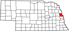
Location of Washington County in Nebraska
This is a list of the National Register of Historic Places listings in Washington County, Nebraska.
This is intended to be a complete list of the properties and districts on the National Register of Historic Places in Washington County, Nebraska, United States. The locations of National Register properties and districts for which the latitude and longitude coordinates are included below, may be seen in a Google map.[1]
There are 13 properties and districts listed on the National Register in the county, including 1 National Historic Landmark.
- This National Park Service list is complete through NPS recent listings posted May 1, 2015.[2]
Current listings
| [3] |
Name on the Register[4] |
Image |
Date listed[5] |
Location |
City or town |
Description |
|---|
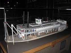
| 1 |
Bertrand Site |
|
01969-03-24-0000March 24, 1969
(#69000138) |
DeSoto National Wildlife Refuge
41°31′24″N 96°01′44″W / 41.523333°N 96.028889°W / 41.523333; -96.028889 (Bertrand Site) |
Blair |
|
| 2 |
Blair High School |
|
01991-03-14-0000March 14, 1991
(#91000300) |
Junction of 16th and Colfax Sts.
41°32′24″N 96°08′10″W / 41.54°N 96.136111°W / 41.54; -96.136111 (Blair High School) |
Blair |
|
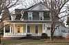
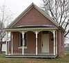
| 3 |
Abraham Castetter House |
|
01982-06-25-0000June 25, 1982
(#82003203) |
1815 Grant St.
41°32′30″N 96°08′23″W / 41.54159°N 96.13967°W / 41.54159; -96.13967 (Abraham Castetter House) |
Blair |
|
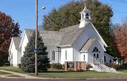
| 4 |
Congregational Church of Blair |
|
01979-02-01-0000February 1, 1979
(#79001457) |
16th and Colfax Sts.
41°32′27″N 96°08′11″W / 41.540972°N 96.136444°W / 41.540972; -96.136444 (Congregational Church of Blair) |
Blair |
|
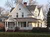
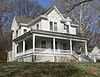
| 5 |
C.C. Crowell, Jr. House |
|
01982-07-19-0000July 19, 1982
(#82003204) |
2138 Washington St.
41°32′39″N 96°08′42″W / 41.5441°N 96.14505°W / 41.5441; -96.14505 (C.C. Crowell, Jr. House) |
Blair |
|
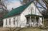
| 6 |
Fontanelle Township Hall |
|
01982-09-09-0000September 9, 1982
(#82003205) |
10976 8th Street[6]
41°32′14″N 96°25′40″W / 41.537361°N 96.427667°W / 41.537361; -96.427667 (Fontanelle Township Hall) |
Fontanelle |
|
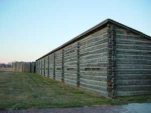
| 7 |
Fort Atkinson |
|
01966-10-15-0000October 15, 1966
(#66000454) |
1 mile east of Fort Calhoun
41°27′23″N 96°00′49″W / 41.456389°N 96.013611°W / 41.456389; -96.013611 (Fort Atkinson) |
Fort Calhoun |
|
| 8 |
Alfred H. and Sarah Frahm House |
|
02006-03-02-0000March 2, 2006
(#06000101) |
220 S. 15th St.
41°27′14″N 96°01′41″W / 41.45398°N 96.02803°W / 41.45398; -96.02803 (Alfred H. and Sarah Frahm House) |
Fort Calhoun |
|
| 9 |
Long Creek School |
|
02001-02-23-0000February 23, 2001
(#01000167) |
Long Creek Lane
41°27′33″N 96°05′15″W / 41.4591°N 96.08748°W / 41.4591; -96.08748 (Long Creek School) |
Blair |
|
| 10 |
Old McDonald Farm |
Upload image |
02001-07-05-0000July 5, 2001
(#01000714) |
2 miles (3.2 km) south of Blair above Mill Creek[7]
41°30′01″N 96°08′00″W / 41.500278°N 96.133333°W / 41.500278; -96.133333 (Old McDonald Farm) |
Blair |
|
| 11 |
Frank Parker Archeological Site |
Upload image |
02009-03-04-0000March 4, 2009
(#09000069) |
Address Restricted
|
Fort Calhoun |
Extends into Douglas County[4]
|
| 12 |
Trinity Seminary Building |
Upload image |
01980-07-03-0000July 3, 1980
(#80004528) |
College Dr.
41°33′02″N 96°08′39″W / 41.550556°N 96.144167°W / 41.550556; -96.144167 (Trinity Seminary Building) |
Blair |
Destroyed by fire in August 1988[8]
|
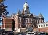
| 13 |
Washington County Courthouse |
|
01990-01-10-0000January 10, 1990
(#89002221) |
16th St. between Colfax and South Sts.
41°32′24″N 96°08′06″W / 41.54°N 96.135°W / 41.54; -96.135 (Washington County Courthouse) |
Blair |
|
See also
References
- ↑ The latitude and longitude information provided in this table was derived originally from the National Register Information System, which has been found to be fairly accurate for about 99% of listings. For about 1% of NRIS original coordinates, experience has shown that one or both coordinates are typos or otherwise extremely far off; some corrections may have been made. A more subtle problem causes many locations to be off by up to 150 yards, depending on location in the country: most NRIS coordinates were derived from tracing out latitude and longitudes off of USGS topographical quadrant maps created under the North American Datum of 1927, which differs from the current, highly accurate WGS84 GPS system used by most on-line maps. Chicago is about right, but NRIS longitudes in Washington are higher by about 4.5 seconds, and are lower by about 2.0 seconds in Maine. Latitudes differ by about 1.0 second in Florida. Some locations in this table may have been corrected to current GPS standards.
- ↑ "National Register of Historic Places: Weekly List Actions". National Park Service, United States Department of the Interior. Retrieved on May 1, 2015.
- ↑ Numbers represent an ordering by significant words. Various colorings, defined here, differentiate National Historic Landmarks and historic districts from other NRHP buildings, structures, sites or objects.
- ↑ 4.0 4.1 "National Register Information System". National Register of Historic Places. National Park Service. 2008-04-24.
- ↑ The eight-digit number below each date is the number assigned to each location in the National Register Information System database, which can be viewed by clicking the number.
- ↑ "Hot Dogs At The Town Hall". Washington County Museum Quarterly Newsletter. Spring 2007. Retrieved 2010-11-23.
- ↑ Stupka-Burda, Stacy. National Register of Historic Places Inventory/Nomination: Old McDonald Farm. National Park Service, 2001-04-17, 5.
- ↑ "Landmarks in Washington County, Nebraska". Washington County Historical Association. Retrieved 2010-10-27.
|
|---|
| | Topics | |
|---|
| | Lists by states | |
|---|
| | Lists by insular areas | |
|---|
| | Lists by associated states | |
|---|
| | Other areas | |
|---|
|
-
 Category Category
-
 Portal Portal
-
 WikiProject WikiProject
|
|