| [3] |
Name on the Register[4] |
Image |
Date listed[5] |
Location |
City or town |
Description |
|---|
| 1 |
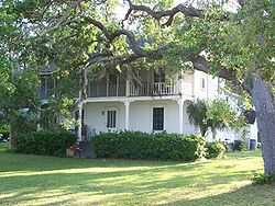
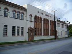
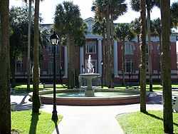
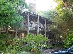
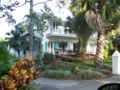
The Abbey |
|
01987-04-09-0000April 9, 1987
(#87000615) |
426 South Beach Street
29°12′17″N 81°01′01″W / 29.204722°N 81.016944°W / 29.204722; -81.016944 (The Abbey) |
Daytona Beach |
|
| 2 |
Airport Clear Zone Archeological Site |
|
02008-07-10-0000July 10, 2008
(#08000639) |
Address Restricted
|
New Smyrna Beach |
Part of the Archeological Resources of the 18th-Century Smyrnea Settlement of Dr. Andrew Turnbull MPS
|
| 3 |
All Saint's Episcopal Church |
|
01974-05-03-0000May 3, 1974
(#74000656) |
Corner of DeBary Avenue Northeast and Clark Street
28°52′10″N 81°16′10″W / 28.869444°N 81.269444°W / 28.869444; -81.269444 (All Saint's Episcopal Church) |
Enterprise |
|
| 4 |
John Anderson Lodge |
|
01989-09-06-0000September 6, 1989
(#88001717) |
71 Orchard Lane
29°17′26″N 81°02′50″W / 29.290556°N 81.047222°W / 29.290556; -81.047222 (John Anderson Lodge) |
Ormond Beach |
Part of the Historic Winter Residences of Ormond Beach, 1878-1925 MPS
|
| 5 |
Anderson-Price Memorial Library Building |
|
01984-01-26-0000January 26, 1984
(#84000967) |
42 North Beach Street
29°17′12″N 81°03′23″W / 29.286667°N 81.056389°W / 29.286667; -81.056389 (Anderson-Price Memorial Library Building) |
Ormond Beach |
|
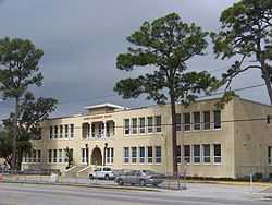
| 6 |
Barberville Central High School |
|
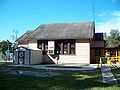
01993-02-03-0000February 3, 1993
(#92001838) |
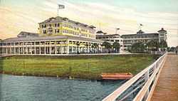
1776 Lightfoot Lane
29°11′00″N 81°25′23″W / 29.183333°N 81.423056°W / 29.183333; -81.423056 (Barberville Central High School) |
Barberville |
|
| 7 |
Mary McLeod Bethune Home |
|
01974-12-02-0000December 2, 1974
(#74000655) |
Bethune-Cookman College campus
29°12′45″N 81°01′56″W / 29.2125°N 81.032222°W / 29.2125; -81.032222 (Mary McLeod Bethune Home) |
Daytona Beach |
Home of educator and civil rights leader Mary McLeod Bethune
|
| 8 |
Bethune-Cookman College Historic District |
|
01996-03-21-0000March 21, 1996
(#96000298) |
620 Dr. Mary McLeod Bethune Boulevard
29°12′43″N 81°01′55″W / 29.211944°N 81.031944°W / 29.211944; -81.031944 (Bethune-Cookman College Historic District) |
Daytona Beach |
Part of the Daytona Beach MPS
|
| 9 |
Blanchette Archeological Site |
|
02008-07-10-0000July 10, 2008
(#08000640) |
Address Restricted
|
New Smyrna Beach |
Part of the Archeological Resources of the 18th-Century Smyrnea Settlement of Dr. Andrew Turnbull MPS
|
| 10 |
Delos A. Blodgett House |
|
01993-08-02-0000August 2, 1993
(#93000724) |
404 Ridgewood Avenue
29°12′16″N 81°01′13″W / 29.204444°N 81.020278°W / 29.204444; -81.020278 (Delos A. Blodgett House) |
Daytona Beach |
|
| 11 |
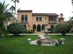
Casements Annex |
|
01988-10-06-0000October 6, 1988
(#88001720) |
127 Riverside Drive
29°17′07″N 81°02′45″W / 29.285278°N 81.045833°W / 29.285278; -81.045833 (Casements Annex) |
Ormond Beach |
Part of the Historic Winter Residences of Ormond Beach, 1878-1925 MPS
|
| 12 |
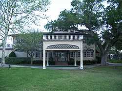
The Casements |
|
01972-06-30-0000June 30, 1972
(#72001536) |
15 East Granada Avenue
29°17′21″N 81°02′45″W / 29.289167°N 81.045833°W / 29.289167; -81.045833 (The Casements) |
Ormond Beach |
|
| 13 |
Chief Master at Arms House |
|
02002-02-15-0000February 15, 2002
(#02000003) |
910 Biscayne Boulevard
29°03′29″N 81°17′18″W / 29.058056°N 81.288333°W / 29.058056; -81.288333 (Chief Master at Arms House) |
DeLand |
Part of the Florida's Historic World War II Military Resources MPS
|
| 14 |
City Island |
|
02000-01-07-0000January 7, 2000
(#99001646) |
108 East Orange Avenue
29°12′34″N 81°00′58″W / 29.209444°N 81.016111°W / 29.209444; -81.016111 (City Island) |
Daytona Beach |
|
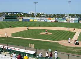
| 15 |
City Island Ball Park |
|
01998-10-22-0000October 22, 1998
(#98001253) |
City Island, across from the Daytona Beach business district
29°12′34″N 81°01′00″W / 29.209444°N 81.016667°W / 29.209444; -81.016667 (City Island Ball Park) |
Daytona Beach |
Part of the Daytona Beach MPS
|
| 16 |
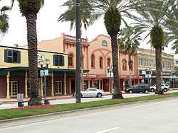
Coronado Historic District |
|
01997-02-21-0000February 21, 1997
(#97000098) |
Roughly bounded by Columbus, Due East, and Pine Avenues, and the Indian River
29°02′19″N 80°54′10″W / 29.038611°N 80.902778°W / 29.038611; -80.902778 (Coronado Historic District) |
New Smyrna Beach |
|
| 17 |
Cypress Street Elementary School |
|
01996-12-02-0000December 2, 1996
(#96001333) |
868 West George W Engram Boulevard
29°12′46″N 81°02′24″W / 29.212778°N 81.04°W / 29.212778; -81.04 (Cypress Street Elementary School) |
Daytona Beach |
Part of the Daytona Beach MPS
|
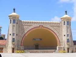
| 18 |
Daytona Beach Bandshell and Oceanfront Park Complex |
|
01999-03-05-0000March 5, 1999
(#99000159) |
Ocean Avenue, north of the junction of Main Street and Atlantic
29°13′41″N 81°00′29″W / 29.228056°N 81.008056°W / 29.228056; -81.008056 (Daytona Beach Bandshell and Oceanfront Park Complex) |
Daytona Beach |
Part of the Daytona Beach MPS
|
| 19 |
Daytona Beach Surfside Historic District |
|
01996-08-01-0000August 1, 1996
(#96000851) |
Roughly bounded by Auditorium Boulevard, the Atlantic Ocean, U.S. Route 92, and the Halifax River
29°13′30″N 81°00′36″W / 29.225°N 81.01°W / 29.225; -81.01 (Daytona Beach Surfside Historic District) |
Daytona Beach |
Part of the Daytona Beach MPS
|
| 20 |
DeBary Hall |
|
01972-07-24-0000July 24, 1972
(#72000354) |
DeBary Mansion State Park
28°52′29″N 81°17′50″W / 28.874722°N 81.297222°W / 28.874722; -81.297222 (DeBary Hall) |
DeBary |
|
| 21 |
DeLand Hall |
|
01983-01-27-0000January 27, 1983
(#83001441) |
Stetson University campus
29°02′06″N 81°18′12″W / 29.035°N 81.303333°W / 29.035; -81.303333 (DeLand Hall) |
DeLand |
|
| 22 |
DeLeon Springs Colored School |
|
02003-08-01-0000August 1, 2003
(#03000702) |
330 East Retta Street
29°06′51″N 81°20′51″W / 29.114167°N 81.3475°W / 29.114167; -81.3475 (DeLeon Springs Colored School) |
DeLeon Springs |
Part of the Florida's Historic Black Public Schools MPS
|
| 23 |
Dickinson Memorial Library and Park |
|
01995-02-08-0000February 8, 1995
(#95000020) |
148 South Volusia Avenue (US 17)
28°56′52″N 81°17′55″W / 28.947778°N 81.298611°W / 28.947778; -81.298611 (Dickinson Memorial Library and Park) |
Orange City |
|
| 24 |
Dix House |
|
01989-09-06-0000September 6, 1989
(#88001721) |
178 North Beach Street
29°17′25″N 81°03′28″W / 29.290278°N 81.057778°W / 29.290278; -81.057778 (Dix House) |
Ormond Beach |
Part of the Historic Winter Residences of Ormond Beach, 1878-1925 MPS
|
| 25 |
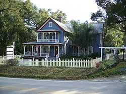
Bartholomew J. Donnelly House |
|
01993-08-02-0000August 2, 1993
(#93000726) |
801 North Peninsula Drive
29°14′16″N 81°01′10″W / 29.237778°N 81.019444°W / 29.237778; -81.019444 (Bartholomew J. Donnelly House) |
Daytona Beach |
|
| 26 |
Downtown DeLand Historic District |
|
01987-12-23-0000December 23, 1987
(#87001796) |
Roughly bounded by Florida and Rich Avenues, Woodland Boulevard, and Howry Avenue
29°01′39″N 81°18′17″W / 29.0275°N 81.304722°W / 29.0275; -81.304722 (Downtown DeLand Historic District) |
DeLand |
|
| 27 |
Dunlawton Avenue Historic District |
|
01998-02-05-0000February 5, 1998
(#98000055) |
Roughly along Dunlawton Avenue to Lafayette Avenue, and Orange Avenue and Wellman Street
29°08′32″N 80°59′29″W / 29.142222°N 80.991389°W / 29.142222; -80.991389 (Dunlawton Avenue Historic District) |
Port Orange |
Part of the Port Orange MPS
|
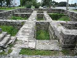
| 28 |
Dunlawton Plantation-Sugar Mill Ruins |
|
01973-08-28-0000August 28, 1973
(#73000606) |
950 Old Sugar Mill Road
29°08′29″N 81°00′26″W / 29.141389°N 81.007222°W / 29.141389; -81.007222 (Dunlawton Plantation-Sugar Mill Ruins) |
Port Orange |
|
| 29 |
El Pino Parque Historic District |
|
01993-04-26-0000April 26, 1993
(#93000318) |
1412-1604 North Halifax Drive
29°15′07″N 81°01′44″W / 29.251944°N 81.028889°W / 29.251944; -81.028889 (El Pino Parque Historic District) |
Daytona Beach |
|
| 30 |
El Real Retiro |
|
01987-11-10-0000November 10, 1987
(#87001557) |
636 North Riverside Drive and 647 Faulkner Street
29°02′04″N 80°55′41″W / 29.034444°N 80.928056°W / 29.034444; -80.928056 (El Real Retiro) |
New Smyrna Beach |
|
| 31 |
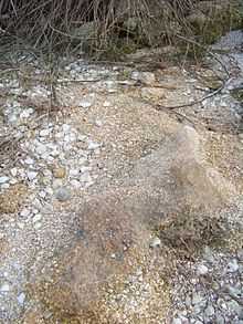
First Presbyterian Church Archeological Site |
Upload image |
02008-07-10-0000July 10, 2008
(#08000635) |
509 Magnolia Street[6]
29°01′16″N 80°55′12″W / 29.021000°N 80.920000°W / 29.021000; -80.920000 (First Presbyterian Church Archeological Site) |
New Smyrna Beach |
Part of the Archeological Resources of the 18th-Century Smyrnea Settlement of Dr. Andrew Turnbull MPS
|
| 32 |
Seth French House |
|
02003-02-12-0000February 12, 2003
(#03000005) |
319 East French Avenue
28°57′09″N 81°17′47″W / 28.952500°N 81.296389°W / 28.952500; -81.296389 (Seth French House) |
Orange City |
|
| 33 |
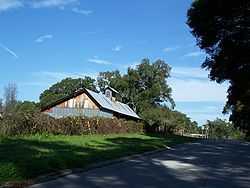
Gamble Place Historic District |
|
01993-09-29-0000September 29, 1993
(#93000563) |
1819 Taylor Road
29°05′22″N 81°02′44″W / 29.089444°N 81.045556°W / 29.089444; -81.045556 (Gamble Place Historic District) |
Port Orange |
|
| 34 |
Grace Episcopal Church and Guild Hall |
|
01998-02-05-0000February 5, 1998
(#98000058) |
4100 Ridgewood Avenue
29°08′35″N 80°59′14″W / 29.143056°N 80.987222°W / 29.143056; -80.987222 (Grace Episcopal Church and Guild Hall) |
Port Orange |
Part of the Port Orange MPS
|
| 35 |
Grange Archeological Site |
|
02008-07-10-0000July 10, 2008
(#08000631) |
Address Restricted
|
New Smyrna Beach |
Part of the Archeological Resources of the 18th-Century Smyrnea Settlement of Dr. Andrew Turnbull MPS
|
| 36 |
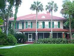
The Hammocks |
|
01989-09-05-0000September 5, 1989
(#88001719) |
311 John Anderson Highway
29°17′51″N 81°03′06″W / 29.297500°N 81.051667°W / 29.297500; -81.051667 (The Hammocks) |
Ormond Beach |
Part of the Historic Winter Residences of Ormond Beach, 1878-1925 MPS
|
| 37 |
Hawks Archeological Site |
|
02008-07-10-0000July 10, 2008
(#08000636) |
Address Restricted
|
Edgewater |
Part of the Archeological Resources of the 18th-Century Smyrnea Settlement of Dr. Andrew Turnbull MPS
|
| 38 |
Alexander Haynes House |
|
01995-09-07-0000September 7, 1995
(#95001070) |
128 West Howry Avenue
29°01′33″N 81°18′18″W / 29.025833°N 81.305°W / 29.025833; -81.305 (Alexander Haynes House) |
DeLand |
|
| 39 |
Holly Hill Municipal Building |
|
01993-04-08-0000April 8, 1993
(#93000285) |
1065 Ridgewood Avenue
29°14′43″N 81°02′25″W / 29.245278°N 81.040278°W / 29.245278; -81.040278 (Holly Hill Municipal Building) |
Holly Hill |
|
| 40 |
Janet's Archeological Site |
|
02008-07-10-0000July 10, 2008
(#08000630) |
Address Restricted
|
New Smyrna Beach |
Part of the Archeological Resources of the 18th-Century Smyrnea Settlement of Dr. Andrew Turnbull MPS
|
| 41 |
Kilkoff House |
|
01997-10-08-0000October 8, 1997
(#97001216) |
1145 West New York Avenue
29°01′42″N 81°19′33″W / 29.028333°N 81.325833°W / 29.028333; -81.325833 (Kilkoff House) |
DeLand |
|
| 42 |
Amos Kling House |
|
01993-12-02-0000December 2, 1993
(#93001353) |
220-222 Magnolia Avenue
29°12′34″N 81°01′18″W / 29.209444°N 81.021667°W / 29.209444; -81.021667 (Amos Kling House) |
Daytona Beach |
|
| 43 |
S.H. Kress and Co. Building |
|
01983-07-07-0000July 7, 1983
(#83001442) |
140 South Beach Street
29°12′38″N 81°01′10″W / 29.210556°N 81.019444°W / 29.210556; -81.019444 (S.H. Kress and Co. Building) |
Daytona Beach |
|
| 44 |
Lake Helen Historic District |
|
01993-09-16-0000September 16, 1993
(#93000981) |
Roughly bounded by West New York, Lakeview, Park, and Euclid Avenues
28°59′18″N 81°14′03″W / 28.988333°N 81.234167°W / 28.988333; -81.234167 (Lake Helen Historic District) |
Lake Helen |
Part of the Lake Helen MPS
|
| 45 |
Lippincott Mansion |
|
01985-02-21-0000February 21, 1985
(#85000304) |
150 South Beach Street
29°16′51″N 81°03′15″W / 29.280833°N 81.054167°W / 29.280833; -81.054167 (Lippincott Mansion) |
Ormond Beach |
|
| 46 |
Merchants Bank Building |
|
01986-01-06-0000January 6, 1986
(#86000025) |
252 South Beach Street
29°12′30″N 81°00′29″W / 29.208333°N 81.008056°W / 29.208333; -81.008056 (Merchants Bank Building) |
Daytona Beach |
|
| 47 |
Moulton-Wells House |
|
02001-11-21-0000November 21, 2001
(#01001247) |
West of Eldora Road on the Canaveral National Seashore
28°54′32″N 80°49′16″W / 28.908889°N 80.821111°W / 28.908889; -80.821111 (Moulton-Wells House) |
New Smyrna Beach |
|
| 48 |
Mount Taylor |
|
01997-10-08-0000October 8, 1997
(#97001219) |
Address Restricted
|
DeBary |
|
| 49 |
New Smyrna Beach Historic District |
|
01990-04-26-0000April 26, 1990
(#90000714) |
Roughly bounded by Riverside Drive, U.S. Route 1, Ronnoc Lane, and Smith Street
29°01′30″N 80°55′27″W / 29.025°N 80.924167°W / 29.025; -80.924167 (New Smyrna Beach Historic District) |
New Smyrna Beach |
|
| 50 |
New Smyrna Sugar Mill Ruins |
|
01970-08-12-0000August 12, 1970
(#70000192) |
600 Old Mission Road
29°00′34″N 80°56′25″W / 29.009444°N 80.940278°W / 29.009444; -80.940278 (New Smyrna Sugar Mill Ruins) |
New Smyrna Beach |
|
| 51 |
Old DeLand Memorial Hospital |
|
01989-11-27-0000November 27, 1989
(#89002030) |
Stone Street
29°02′37″N 81°19′03″W / 29.043611°N 81.3175°W / 29.043611; -81.3175 (Old DeLand Memorial Hospital) |
DeLand |
|
| 52 |
Old Fort Park Archeological Site |
|
02008-07-10-0000July 10, 2008
(#08000629) |
Address Restricted
29°01′38″N 80°55′20″W / 29.027222°N 80.922222°W / 29.027222; -80.922222 (Old Fort Park Archeological Site) |
New Smyrna Beach |
Part of the Archeological Resources of the 18th-Century Smyrnea Settlement of Dr. Andrew Turnbull MPS
|
| 53 |
Old Stone Wharf Archeological Site |
|
02008-07-10-0000July 10, 2008
(#08000638) |
Address Restricted
29°01′11″N 80°55′07″W / 29.019722°N 80.918611°W / 29.019722; -80.918611 (Old Stone Wharf Archeological Site) |
New Smyrna Beach |
Part of the Archeological Resources of the 18th-Century Smyrnea Settlement of Dr. Andrew Turnbull MPS
|
| 54 |
Nocoroco |
|
01973-05-07-0000May 7, 1973
(#73000605) |
2 miles north of Ormond Beach
29°21′07″N 81°05′14″W / 29.351944°N 81.087222°W / 29.351944; -81.087222 (Nocoroco) |
Ormond Beach |
|
| 55 |
Olds Hall |
|
01993-09-23-0000September 23, 1993
(#93001003) |
340 South Ridgewood Avenue
29°12′18″N 81°01′13″W / 29.205°N 81.020278°W / 29.205; -81.020278 (Olds Hall) |
Daytona Beach |
|
| 56 |
Orange City Colored School |
|
02003-08-01-0000August 1, 2003
(#03000703) |
200 East Blue Springs Avenue
28°56′19″N 81°17′49″W / 28.938611°N 81.296944°W / 28.938611; -81.296944 (Orange City Colored School) |
Orange City |
Part of the Florida's Historic Black Public Schools MPS
|
| 57 |
Orange City Historic District |
|
02004-04-06-0000April 6, 2004
(#04000265) |
Roughly Banana, Carpenter, French and Orange Avenues
28°56′56″N 81°17′57″W / 28.948889°N 81.299167°W / 28.948889; -81.299167 (Orange City Historic District) |
Orange City |
Part of the Orange City, Florida MPS
|
| 58 |
Orange City Town Hall |
|
02002-05-16-0000May 16, 2002
(#02000493) |
205 East Graves Avenue
28°56′56″N 81°17′52″W / 28.948889°N 81.297778°W / 28.948889; -81.297778 (Orange City Town Hall) |
Orange City |
|
| 59 |
Ormond Fire House |
|
02010-12-15-0000December 15, 2010
(#10001033) |
160 East Granada Boulevard
29°17′27″N 81°02′32″W / 29.290833°N 81.042222°W / 29.290833; -81.042222 (Ormond Fire House) |
Ormond Beach |
|
| 60 |
Ormond Hotel |
|
01980-11-24-0000November 24, 1980
(#80000964) |
15 East Granada Boulevard
29°17′22″N 81°02′50″W / 29.289444°N 81.047222°W / 29.289444; -81.047222 (Ormond Hotel) |
Ormond Beach |
Demolished in 1992, only hotel's cupola preserved in nearby park[7]
|
| 61 |
Ormond Yacht Club |
|
02005-04-19-0000April 19, 2005
(#05000310) |
63 North Beach Street
29°17′16″N 81°03′21″W / 29.287778°N 81.055833°W / 29.287778; -81.055833 (Ormond Yacht Club) |
Ormond Beach |
|
| 62 |
Persimmon Mound |
|
01994-04-14-0000April 14, 1994
(#94000357) |
Baxter Point Road on the northern side of the St. Johns River[8]:5
28°36′56″N 80°58′12″W / 28.615556°N 80.970000°W / 28.615556; -80.970000 (Persimmon Mound) |
Rockledge |
Originally recorded as being a short distance away in Brevard County[8]:4
|
| 63 |
Ponce De Leon Inlet Lightstation |
|
01972-09-22-0000September 22, 1972
(#72000355) |
4931 South Peninsula Drive, U.S. Coast Guard Reservation
29°04′50″N 80°55′42″W / 29.080556°N 80.928333°W / 29.080556; -80.928333 (Ponce De Leon Inlet Lightstation) |
Ponce Inlet |
|
| 64 |
The Porches |
|
01988-10-06-0000October 6, 1988
(#88001715) |
176 South Beach Street
29°16′52″N 81°03′14″W / 29.281111°N 81.053889°W / 29.281111; -81.053889 (The Porches) |
Ormond Beach |
Part of the Historic Winter Residences of Ormond Beach, 1878-1925 MPS
|
| 65 |
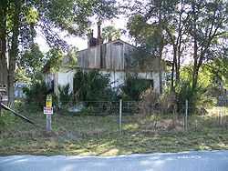
Port Orange Florida East Coast Railway Freight Depot |
|
01998-02-05-0000February 5, 1998
(#98000057) |
415C Herbert Street
29°08′37″N 80°59′36″W / 29.143611°N 80.993333°W / 29.143611; -80.993333 (Port Orange Florida East Coast Railway Freight Depot) |
Port Orange |
Part of the Port Orange MPS
|
| 66 |
Rogers House |
|
01986-09-11-0000September 11, 1986
(#86002407) |
436 North Beach Street
29°13′09″N 81°00′50″W / 29.219167°N 81.013889°W / 29.219167; -81.013889 (Rogers House) |
Daytona Beach |
|
| 67 |
Ross Hammock Site |
|
01981-02-05-0000February 5, 1981
(#81000083) |
Address Restricted
|
Oak Hill |
|
| 68 |
Rowallan |
|
01988-10-06-0000October 6, 1988
(#88001724) |
253 John Anderson Highway
29°17′36″N 81°02′59″W / 29.293333°N 81.049722°W / 29.293333; -81.049722 (Rowallan) |
Ormond Beach |
Part of the Historic Winter Residences of Ormond Beach, 1878-1925 MPS
|
| 69 |
St. Rita's Colored Catholic Mission |
|
02007-04-13-0000April 13, 2007
(#07000280) |
314 Duss Street
29°01′27″N 80°55′56″W / 29.024167°N 80.932222°W / 29.024167; -80.932222 (St. Rita's Colored Catholic Mission) |
New Smyrna Beach |
|
| 70 |
Seabreeze Historic District |
|
01998-09-03-0000September 3, 1998
(#98001131) |
Roughly bounded by University Boulevard, the Halifax River, Auditorium Boulevard, and North Atlantic Avenue
29°13′58″N 81°02′34″W / 29.232778°N 81.042778°W / 29.232778; -81.042778 (Seabreeze Historic District) |
Daytona Beach |
Part of the Daytona Beach MPS
|
| 71 |
Seminole Rest |
|
01997-03-19-0000March 19, 1997
(#97000231) |
East of State Road 5 on the western shore of Mosquito Lagoon at the Canaveral National Seashore
28°52′11″N 80°50′15″W / 28.869722°N 80.8375°W / 28.869722; -80.8375 (Seminole Rest) |
Oak Hill |
|
| 72 |
Seybold Baking Company Factory |
|
01997-10-30-0000October 30, 1997
(#97001283) |
800 Orange Avenue
29°12′09″N 81°01′55″W / 29.2025°N 81.031944°W / 29.2025; -81.031944 (Seybold Baking Company Factory) |
Daytona Beach |
Part of the Daytona Beach MPS
|
| 73 |
Sleepy Hollow Archeological Site |
|
02008-07-10-0000July 10, 2008
(#08000637) |
Address Restricted
|
New Smyrna Beach |
Part of the Archeological Resources of the 18th-Century Smyrnea Settlement of Dr. Andrew Turnbull MPS
|
| 74 |
South Beach Street Historic District |
|
01988-09-15-0000September 15, 1988
(#88001597) |
Roughly bounded by Volusia Avenue, South Beach Street, South Street, and U.S. Route 1
29°12′18″N 81°01′03″W / 29.205°N 81.0175°W / 29.205; -81.0175 (South Beach Street Historic District) |
Daytona Beach |
|
| 75 |
South Peninsula Historic District |
|
01998-11-19-0000November 19, 1998
(#98001379) |
Roughly the Daytona Beach Peninsula between the Atlantic Ocean and the Halifax River
29°12′37″N 81°00′20″W / 29.210278°N 81.005556°W / 29.210278; -81.005556 (South Peninsula Historic District) |
Daytona Beach |
Part of the Daytona Beach MPS
|
| 76 |
South Ridgewood Elementary School |
|
02011-07-14-0000July 14, 2011
(#11000436) |
747 S. Ridgewood Ave.
29°11′55″N 81°00′56″W / 29.198611°N 81.015556°W / 29.198611; -81.015556 (South Ridgewood Elementary School) |
Daytona Beach |
|
| 77 |
Southern Cassadaga Spiritualist Camp Historic District |
|
01991-03-14-0000March 14, 1991
(#91000249) |
Roughly bounded by Cassadaga Road and Marion, Stevens, Lake, and Chauncey Streets
28°57′52″N 81°14′14″W / 28.964444°N 81.237222°W / 28.964444; -81.237222 (Southern Cassadaga Spiritualist Camp Historic District) |
Cassadaga |
|
| 78 |
Southwest Daytona Beach Black Heritage District |
|
01997-05-23-0000May 23, 1997
(#97000457) |
Roughly bounded by Foote Court, South Street, Dr. Martin Luther King Boulevard, and the Florida East Coast railroad tracks
29°12′08″N 81°01′26″W / 29.202222°N 81.023889°W / 29.202222; -81.023889 (Southwest Daytona Beach Black Heritage District) |
Daytona Beach |
Part of the Daytona Beach MPS
|
| 79 |
Spruce Creek Mound Complex |
|
01990-12-03-0000December 3, 1990
(#90001761) |
Address Restricted
|
Port Orange |
|
| 80 |
Stetson University Campus Historic District |
|
01991-03-14-0000March 14, 1991
(#91000244) |
Roughly bounded by Michigan Avenue, North Florida Avenue, West University Avenue, and a line south from North Hayden Avenue
29°02′06″N 81°18′13″W / 29.035°N 81.303611°W / 29.035; -81.303611 (Stetson University Campus Historic District) |
DeLand |
|
| 81 |
John B. Stetson House |
|
01978-11-21-0000November 21, 1978
(#78000957) |
1031 Camphor Lane
29°01′24″N 81°19′25″W / 29.023333°N 81.323611°W / 29.023333; -81.323611 (John B. Stetson House) |
DeLand |
|
| 82 |
Ann Stevens House |
|
01993-08-18-0000August 18, 1993
(#93000734) |
201 East Kicklighter Road
28°58′10″N 81°14′00″W / 28.969444°N 81.233333°W / 28.969444; -81.233333 (Ann Stevens House) |
Lake Helen |
Part of the Lake Helen MPS
|
| 83 |
Stockton-Lindquist House |
|
02004-06-22-0000June 22, 2004
(#04000626) |
244 East Beresford Avenue
29°00′48″N 81°17′59″W / 29.013333°N 81.299722°W / 29.013333; -81.299722 (Stockton-Lindquist House) |
DeLand |
|
| 84 |
Strawn Historic Agricultural District |
|
01993-09-13-0000September 13, 1993
(#93000929) |
Bounded by Broderick and Retta Streets and by Central and Dundee Avenues
29°06′56″N 81°20′56″W / 29.115556°N 81.348889°W / 29.115556; -81.348889 (Strawn Historic Agricultural District) |
DeLeon Springs |
Part of the Citrus Industry Resources of Theodore Strawn, Inc., MPS
|
| 85 |
Strawn Historic Citrus Packing House District |
|
01993-09-13-0000September 13, 1993
(#93000931) |
5707 Lake Winona Road
29°08′18″N 81°21′35″W / 29.138333°N 81.359722°W / 29.138333; -81.359722 (Strawn Historic Citrus Packing House District) |
DeLeon Springs |
Part of the Citrus Industry Resources of Theodore Strawn, Inc., MPS
|
| 86 |
Strawn Historic Sawmill District |
|
01993-09-13-0000September 13, 1993
(#93000930) |
5710 Lake Winona Road
29°08′21″N 81°21′38″W / 29.139167°N 81.360556°W / 29.139167; -81.360556 (Strawn Historic Sawmill District) |
DeLeon Springs |
Part of the Citrus Industry Resources of Theodore Strawn, Inc., MPS
|
| 87 |
Talahloka |
|
01989-09-06-0000September 6, 1989
(#88001716) |
19 Orchard Lane
29°17′26″N 81°02′53″W / 29.290556°N 81.048056°W / 29.290556; -81.048056 (Talahloka) |
Ormond Beach |
Part of the Historic Winter Residences of Ormond Beach, 1878-1925 MPS
|
| 88 |
Tarragona Tower |
|
02005-05-06-0000May 6, 2005
(#05000368) |
Tarragona Way and International Speedway Boulevard
29°12′00″N 81°02′49″W / 29.2°N 81.046944°W / 29.2; -81.046944 (Tarragona Tower) |
Daytona Beach |
|
| 89 |
Three Chimneys Archaeological Site |
|
02010-09-16-0000September 16, 2010
(#10000757) |
715 West Granada Boulevard
29°16′41″N 81°04′26″W / 29.278000°N 81.074000°W / 29.278000; -81.074000 (Three Chimneys Archaeological Site) |
Ormond Beach |
|
| 90 |
Howard Thurman House |
|
01990-02-23-0000February 23, 1990
(#90000100) |
614 Whitehall Street
29°11′54″N 81°01′19″W / 29.198333°N 81.021944°W / 29.198333; -81.021944 (Howard Thurman House) |
Daytona Beach |
Home of educator and civil rights leader Howard Thurman
|
| 91 |
Louis P. Thursby House |
|
02000-05-11-0000May 11, 2000
(#00000468) |
Located inside Blue Spring State Park
28°56′41″N 81°20′21″W / 28.944722°N 81.339167°W / 28.944722; -81.339167 (Louis P. Thursby House) |
Orange City |
|
| 92 |
Tourist Church |
|
01995-10-06-0000October 6, 1995
(#95001139) |
501 North Wild Olive Avenue
29°13′59″N 81°00′52″W / 29.233056°N 81.014444°W / 29.233056; -81.014444 (Tourist Church) |
Daytona Beach |
|
| 93 |
Turnbull Canal System |
|
02007-08-24-0000August 24, 2007
(#07000840) |
Address Restricted
|
New Smyrna Beach |
Part of the Archeological Resources of the 18th-Century Smyrnea Settlement of Dr. Andrew Turnbull MPS
|
| 94 |
Turnbull Colonists' House Archeological Site |
|
02008-07-10-0000July 10, 2008
(#08000632) |
1919 North Dixie Freeway
29°03′17″N 80°56′23″W / 29.054722°N 80.939722°W / 29.054722; -80.939722 (Turnbull Colonists' House Archeological Site) |
New Smyrna Beach |
Part of the Archeological Resources of the 18th-Century Smyrnea Settlement of Dr. Andrew Turnbull MPS
|
| 95 |
Turnbull Colonists' House No. 2 Archeological Site |
|
02008-07-10-0000July 10, 2008
(#08000633) |
Address Restricted
|
New Smyrna Beach |
Part of the Archeological Resources of the 18th-Century Smyrnea Settlement of Dr. Andrew Turnbull MPS
|
| 96 |
Turtle Mound |
|
01970-09-29-0000September 29, 1970
(#70000193) |
Canaveral National Seashore, south of Bethune Beach[9]
28°55′51″N 80°49′37″W / 28.930833°N 80.826944°W / 28.930833; -80.826944 (Turtle Mound) |
New Smyrna Beach |
|
| 97 |
US Post Office |
|
01988-06-30-0000June 30, 1988
(#88000974) |
220 North Beach Street
29°12′51″N 81°01′16″W / 29.214167°N 81.021111°W / 29.214167; -81.021111 (US Post Office) |
Daytona Beach |
|
| 98 |
West DeLand Residential District |
|
01992-11-20-0000November 20, 1992
(#92001617) |
Roughly bounded by University, Florida, New York and Orange Avenues
29°01′57″N 81°18′37″W / 29.0325°N 81.310278°W / 29.0325; -81.310278 (West DeLand Residential District) |
DeLand |
|
| 99 |
White-Fox House Archeological Site |
|
02008-07-10-0000July 10, 2008
(#08000634) |
Address Restricted
|
New Smyrna Beach |
Part of the Archeological Resources of the 18th-Century Smyrnea Settlement of Dr. Andrew Turnbull MPS
|
| 100 |
White Hall |
|
01992-07-15-0000July 15, 1992
(#92000849) |
640 Dr. Mary McLeod Bethune Boulevard
29°12′43″N 81°01′57″W / 29.211944°N 81.0325°W / 29.211944; -81.0325 (White Hall) |
Daytona Beach |
|
| 101 |
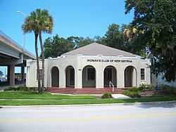
Woman's Club of New Smyrna |
|
01989-05-11-0000May 11, 1989
(#89000410) |
403 Magnolia Street
29°01′20″N 80°55′16″W / 29.022222°N 80.921111°W / 29.022222; -80.921111 (Woman's Club of New Smyrna) |
New Smyrna Beach |
|
| 102 |
S. Cornelia Young Memorial Library |
|
01992-06-25-0000June 25, 1992
(#92000823) |
302 Vermont Avenue
29°13′10″N 81°00′36″W / 29.219444°N 81.01°W / 29.219444; -81.01 (S. Cornelia Young Memorial Library) |
Daytona Beach |
|


_0786.JPG)