| [4] |
Name on the Register[5] |
Image |
Date listed[6] |
Location |
City or town |
Description |
|---|
| 1 |
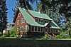
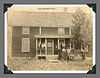
Big Creek Commissary |
Upload image |
02000-04-21-0000April 21, 2000
(#00000327) |
Yellow Pine in the Payette National Forest
45°08′16″N 115°19′08″W / 45.137778°N 115.318889°W / 45.137778; -115.318889 (Big Creek Commissary) |
Yellow Pine |
|
| 2 |
Braddock Gold Mining and Milling Company Log Building and Forge Ruins |
Upload image |
01985-09-12-0000September 12, 1985
(#85002157) |
Off Pack Trail near Suicide Rock
44°59′21″N 115°08′09″W / 44.989167°N 115.135833°W / 44.989167; -115.135833 (Braddock Gold Mining and Milling Company Log Building and Forge Ruins) |
Thunder City |
|
| 3 |
Cabin Creek Ranch |
Upload image |
01990-06-27-0000June 27, 1990
(#90000890) |
Cabin Creek at its confluence with Big Creek in the Payette National Forest
45°08′14″N 114°56′01″W / 45.137222°N 114.933611°W / 45.137222; -114.933611 (Cabin Creek Ranch) |
Black Butte |
|
| 4 |
Elo School |
|
01982-07-26-0000July 26, 1982
(#82002515) |
Southeast of State Highway 55 on Farm to Market Rd.
44°53′10″N 116°03′34″W / 44.886111°N 116.059444°W / 44.886111; -116.059444 (Elo School) |
McCall |
|
| 5 |
Matt N. Hill Homestead Barn |
Upload image |
01982-11-17-0000November 17, 1982
(#82000362) |
Southeast of McCall
44°53′02″N 116°03′26″W / 44.883889°N 116.057222°W / 44.883889; -116.057222 (Matt N. Hill Homestead Barn) |
McCall |
|
| 6 |
Thomas Jarvi Homestead |
Upload image |
01982-11-17-0000November 17, 1982
(#82000363) |
East of Lake Fork on Finn Rd.
44°49′58″N 116°04′49″W / 44.832778°N 116.080278°W / 44.832778; -116.080278 (Thomas Jarvi Homestead) |
Lake Fork |
|
| 7 |
John G. Johnson (Rintakangas) Homestead |
Upload image |
01982-11-17-0000November 17, 1982
(#82000364) |
Northeast of Lake Fork off Pearson Rd.
44°52′01″N 116°02′56″W / 44.866944°N 116.048889°W / 44.866944; -116.048889 (John G. Johnson (Rintakangas) Homestead) |
Lake Fork |
|
| 8 |
John S. Johnson (Sampila) Homestead |
|
01982-11-17-0000November 17, 1982
(#82000365) |
Northeast of Lake Fork off Pearson Rd.
44°51′40″N 116°03′33″W / 44.861111°N 116.059167°W / 44.861111; -116.059167 (John S. Johnson (Sampila) Homestead) |
Lake Fork |
|
| 9 |
John Korvola Homestead |
|
01982-11-17-0000November 17, 1982
(#82000366) |
Roseberry Rd. and Farm to Market Rd.
44°44′12″N 116°04′20″W / 44.736667°N 116.072222°W / 44.736667; -116.072222 (John Korvola Homestead) |
Donnelly |
|
| 10 |
Charles Koski Homestead |
|
01982-11-17-0000November 17, 1982
(#82000367) |
Southeast of McCall
44°53′16″N 116°05′03″W / 44.887778°N 116.084167°W / 44.887778; -116.084167 (Charles Koski Homestead) |
McCall |
|
| 11 |
Krassel Ranger Station |
Upload image |
01992-11-19-0000November 19, 1992
(#92000688) |
Along the South Fork of the Salmon River, 11 miles west of Yellow Pine, in the Payette National Forest
44°58′14″N 115°43′53″W / 44.970556°N 115.731389°W / 44.970556; -115.731389 (Krassel Ranger Station) |
Yellow Pine |
|
| 12 |
Gust Laituri Homestead |
|
01982-11-17-0000November 17, 1982
(#82000368) |
Northeast of Lake Fork off Pearson Rd.
44°51′40″N 116°04′41″W / 44.861111°N 116.078056°W / 44.861111; -116.078056 (Gust Laituri Homestead) |
Lake Fork |
|
| 13 |
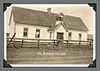
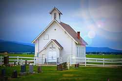
Long Valley Finnish Church |
|
01980-05-27-0000May 27, 1980
(#80001336) |
Southeast of Lake Fork
44°49′05″N 116°02′46″W / 44.818056°N 116.046111°W / 44.818056; -116.046111 (Long Valley Finnish Church) |
Lake Fork |
|
| 14 |
Jacob and Herman Mahala Homestead |
|
01982-11-17-0000November 17, 1982
(#82000369) |
North of Donnelly
44°43′55″N 116°02′42″W / 44.731944°N 116.045°W / 44.731944; -116.045 (Jacob and Herman Mahala Homestead) |
Donnelly |
|
| 15 |
Jacob Maki Homestead |
Upload image |
01982-11-17-0000November 17, 1982
(#82001053) |
Off State Highway 55
44°49′19″N 116°05′53″W / 44.821944°N 116.098056°W / 44.821944; -116.098056 (Jacob Maki Homestead) |
Donnelly |
|
| 16 |
McCall District Administrative Site |
Upload image |
01991-12-30-0000December 30, 1991
(#91001892) |
Junction of W. Lake and Mission Sts.
44°54′35″N 116°06′21″W / 44.909722°N 116.105833°W / 44.909722; -116.105833 (McCall District Administrative Site) |
McCall |
|
| 17 |
North Fork Payette River Bridge |
Upload image |
01999-04-02-0000April 2, 1999
(#99000416) |
State Highway 55, approximately 2.5 miles north of Smiths Ferry
44°19′32″N 116°03′30″W / 44.325556°N 116.058333°W / 44.325556; -116.058333 (North Fork Payette River Bridge) |
Smiths Ferry |
|
| 18 |
Herman Ojala Homestead |
Upload image |
01982-11-17-0000November 17, 1982
(#82000370) |
Northeast of Lake Fork off Pearson Rd.
44°51′58″N 116°04′48″W / 44.866111°N 116.08°W / 44.866111; -116.08 (Herman Ojala Homestead) |
Lake Fork |
|
| 19 |
Rice Meetinghouse |
Upload image |
01980-04-09-0000April 9, 1980
(#80001337) |
Northeast of McCall
44°55′46″N 116°03′50″W / 44.929444°N 116.063889°W / 44.929444; -116.063889 (Rice Meetinghouse) |
McCall |
|
| 20 |
Matt Ruatsale Homestead |
|
01982-11-17-0000November 17, 1982
(#82000371) |
North of Kantola Lane
44°49′42″N 116°02′44″W / 44.828333°N 116.045556°W / 44.828333; -116.045556 (Matt Ruatsale Homestead) |
Lake Fork |
|
| 21 |
Southern Idaho Timber Protective Association (SITPA) Buildings |
|
01990-05-02-0000May 2, 1990
(#90000680) |
1001 State St.
44°54′35″N 116°06′29″W / 44.909722°N 116.108056°W / 44.909722; -116.108056 (Southern Idaho Timber Protective Association (SITPA) Buildings) |
McCall |
|
| 22 |
Southern Idaho Timber Protective Association (SITPA) Buildings |
|
01990-05-02-0000May 2, 1990
(#90000681) |
State Highway 55
44°18′04″N 116°05′21″W / 44.301111°N 116.089167°W / 44.301111; -116.089167 (Southern Idaho Timber Protective Association (SITPA) Buildings) |
Smiths Ferry |
|
| 23 |
Stibnite Historic District |
Upload image |
01987-07-19-0000July 19, 1987
(#87001186) |
United States Forest Service Road 412
44°54′39″N 115°20′17″W / 44.910833°N 115.338056°W / 44.910833; -115.338056 (Stibnite Historic District) |
Yellow Pine |
|
| 24 |
Nickolai Wargelin Homestead |
Upload image |
01982-11-17-0000November 17, 1982
(#82000372) |
Southeast of McCall
44°53′03″N 116°04′05″W / 44.884167°N 116.068056°W / 44.884167; -116.068056 (Nickolai Wargelin Homestead) |
McCall |
|

_Homestead.JPG)

.JPG)
.JPG)
.JPG)