| [3] |
Name on the Register[4] |
Image |
Date listed[5] |
Location |
City or town |
Description |
|---|
| 1 |
Bank of Commerce |
Upload image |
01982-03-25-0000March 25, 1982
(#82002145) |
200 N. Washington St.
33°12′45″N 92°39′52″W / 33.2125°N 92.664444°W / 33.2125; -92.664444 (Bank of Commerce) |
El Dorado |
|
| 2 |
Dual State Monument |
Upload image |
02000-09-11-0000September 11, 2000
(#99001354) |
County Road 86
33°00′39″N 92°22′05″W / 33.010833°N 92.368056°W / 33.010833; -92.368056 (Dual State Monument) |
Aurelle |
Extends into Union Parish, Louisiana
|
| 3 |
El Dorado Apartments |
Upload image |
01983-12-01-0000December 1, 1983
(#83003549) |
420 Wilson Pl.
33°12′22″N 92°39′37″W / 33.206111°N 92.660278°W / 33.206111; -92.660278 (El Dorado Apartments) |
El Dorado |
|
| 4 |
El Dorado Commercial Historic District |
Upload image |
02003-08-21-0000August 21, 2003
(#03000773) |
Courthouse Square, portions of Main, Jefferson, Washington, Jackson, Cedar, and Locust Sts.
33°12′40″N 92°39′45″W / 33.211128°N 92.662492°W / 33.211128; -92.662492 (El Dorado Commercial Historic District) |
El Dorado |
|
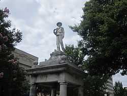
| 5 |
El Dorado Confederate Monument |
|
01996-04-26-0000April 26, 1996
(#96000463) |
Courthouse lawn, near the junction of N. Main St. and S. Washington
33°12′43″N 92°39′48″W / 33.211944°N 92.663333°W / 33.211944; -92.663333 (El Dorado Confederate Monument) |
El Dorado |
|
| 6 |
El Dorado Junior College Building |
Upload image |
01978-09-13-0000September 13, 1978
(#78000633) |
300 S. West Ave.
33°12′34″N 92°39′58″W / 33.209444°N 92.666111°W / 33.209444; -92.666111 (El Dorado Junior College Building) |
El Dorado |
|
| 7 |
Exchange Bank |
|
01986-12-16-0000December 16, 1986
(#86003304) |
Washington and Oak Sts.
33°12′47″N 92°39′49″W / 33.213056°N 92.663611°W / 33.213056; -92.663611 (Exchange Bank) |
El Dorado |
|
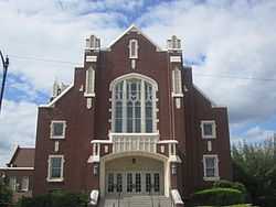
| 8 |
First Presbyterian Church |
|
01991-05-14-0000May 14, 1991
(#91000579) |
300 E. Main
33°12′44″N 92°39′41″W / 33.212222°N 92.661389°W / 33.212222; -92.661389 (First Presbyterian Church) |
El Dorado |
|
| 9 |
Griffin Auto Company Building |
Upload image |
02001-05-25-0000May 25, 2001
(#01000525) |
117 E. Locust St.
33°12′36″N 92°39′45″W / 33.21°N 92.6625°W / 33.21; -92.6625 (Griffin Auto Company Building) |
El Dorado |
|
| 10 |
Mahony Historic District |
Upload image |
02011-12-19-0000December 19, 2011
(#11000899) |
Roughly bounded by Champagnolle Rd., alley between N. Madison & Euclid Aves., Lee Ave. & E. 5th St.
33°13′12″N 92°39′25″W / 33.219981°N 92.657083°W / 33.219981; -92.657083 (Mahony Historic District) |
El Dorado |
|
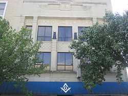
| 11 |
Masonic Temple |
|
02001-04-12-0000April 12, 2001
(#01000349) |
106-108 N. Washington
33°12′44″N 92°39′49″W / 33.212222°N 92.663611°W / 33.212222; -92.663611 (Masonic Temple) |
El Dorado |
|
| 12 |
D. McDonald House |
Upload image |
01990-12-27-0000December 27, 1990
(#90001949) |
800 S. Broadway
33°21′49″N 92°43′33″W / 33.363611°N 92.725833°W / 33.363611; -92.725833 (D. McDonald House) |
Smackover |
|
| 13 |
Henry Crawford McKinney House |
Upload image |
01983-09-01-0000September 1, 1983
(#83001157) |
510 E. Faulkner
33°13′00″N 92°39′39″W / 33.216667°N 92.660833°W / 33.216667; -92.660833 (Henry Crawford McKinney House) |
El Dorado |
|
| 14 |
J.H. McWilliams House |
Upload image |
02002-09-12-0000September 12, 2002
(#02001044) |
323 W. Oak St.
33°12′38″N 92°39′47″W / 33.210556°N 92.663056°W / 33.210556; -92.663056 (J.H. McWilliams House) |
El Dorado |
|
| 15 |
W. F. & Estelle McWilliams House |
|
02013-09-30-0000September 30, 2013
(#13000791) |
314 Summit Ave.
33°12′33″N 92°40′03″W / 33.209213°N 92.667577°W / 33.209213; -92.667577 (W. F. & Estelle McWilliams House) |
El Dorado |
|
| 16 |
Mount Moriah Masonic Lodge No. 18 |
Upload image |
01987-03-13-0000March 13, 1987
(#87000442) |
Off Highway 172
33°16′18″N 92°49′36″W / 33.271667°N 92.826667°W / 33.271667; -92.826667 (Mount Moriah Masonic Lodge No. 18) |
Lisbon |
|
| 17 |
Municipal Building |
Upload image |
01983-06-30-0000June 30, 1983
(#83001167) |
204 N. West Ave.
33°12′43″N 92°39′50″W / 33.211944°N 92.663889°W / 33.211944; -92.663889 (Municipal Building) |
El Dorado |
|
| 18 |
Charles H. Murphy Sr. House |
Upload image |
01983-09-08-0000September 8, 1983
(#83001168) |
900 N. Madison Ave.
33°13′14″N 92°39′37″W / 33.220556°N 92.660278°W / 33.220556; -92.660278 (Charles H. Murphy Sr. House) |
El Dorado |
|
| 19 |
J.T. Murphy No 1 Crater |
Upload image |
02008-01-24-0000January 24, 2008
(#07001435) |
Firetower Rd., 0.75 miles (1.21 km) north of its junction with Baugh St.
33°20′38″N 92°40′06″W / 33.343889°N 92.668333°W / 33.343889; -92.668333 (J.T. Murphy No 1 Crater) |
Norphlet |
|
| 20 |
Murphy-Hill Historic District |
Upload image |
02007-09-20-0000September 20, 2007
(#07000974) |
Roughly bounded by E. 5th St., N. Jefferson St., E. Peach St., N. Madison St., and E. Faulkner St.
33°13′04″N 92°39′39″W / 33.217803°N 92.660867°W / 33.217803; -92.660867 (Murphy-Hill Historic District) |
El Dorado |
|
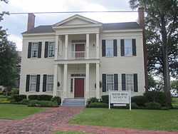
| 21 |
Matthew Rainey House |
|
01974-11-06-0000November 6, 1974
(#74000501) |
510 N. Jackson St.
33°12′53″N 92°39′44″W / 33.214722°N 92.662222°W / 33.214722; -92.662222 (Matthew Rainey House) |
El Dorado |
Now the Newton House Museum
|
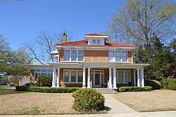
| 22 |
Randolph James House |
Upload image |
02012-05-14-0000May 14, 2012
(#12000277) |
1212 N. Madison Ave.
33°13′23″N 92°39′35″W / 33.223072°N 92.659841°W / 33.223072; -92.659841 (Randolph James House) |
El Dorado |
|
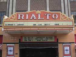
| 23 |
Rialto Theatre |
|
01986-08-21-0000August 21, 1986
(#86001888) |
117 E. Cedar St.
33°12′38″N 92°39′47″W / 33.210556°N 92.663056°W / 33.210556; -92.663056 (Rialto Theatre) |
El Dorado |
|
| 24 |
Scotland Cemetery |
Upload image |
02005-09-28-0000September 28, 2005
(#05001081) |
U.S. Route 167, 3 miles (4.8 km) west of Junction City
33°02′59″N 92°45′03″W / 33.049722°N 92.750833°W / 33.049722; -92.750833 (Scotland Cemetery) |
Junction City |
|
| 25 |
Smackover Historic Commercial District |
Upload image |
01990-06-14-0000June 14, 1990
(#90000884) |
601-628 Broadway
33°21′55″N 92°43′29″W / 33.365278°N 92.724722°W / 33.365278; -92.724722 (Smackover Historic Commercial District) |
Smackover |
|
| 26 |
Joel Smith House |
Upload image |
01990-08-31-0000August 31, 1990
(#90001220) |
Junction of U.S. Route 167 and County Road 5
33°07′38″N 92°38′19″W / 33.127222°N 92.638611°W / 33.127222; -92.638611 (Joel Smith House) |
El Dorado |
|
| 27 |
Smith-McCurry House |
Upload image |
01992-10-15-0000October 15, 1992
(#92001394) |
Northern side of Highway 15, 3.5 miles (5.6 km) east of El Dorado
33°13′16″N 92°35′25″W / 33.221111°N 92.590278°W / 33.221111; -92.590278 (Smith-McCurry House) |
El Dorado |
|
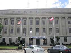
| 28 |
Union County Courthouse |
|
01983-06-30-0000June 30, 1983
(#83001169) |
Union Sq.
33°12′43″N 92°39′50″W / 33.211944°N 92.663889°W / 33.211944; -92.663889 (Union County Courthouse) |
El Dorado |
|
| 29 |
Willett House |
Upload image |
01995-09-14-0000September 14, 1995
(#95001103) |
6563 Mount Holly Rd.
33°16′09″N 92°47′34″W / 33.269167°N 92.792778°W / 33.269167; -92.792778 (Willett House) |
Lisbon |
|