National Register of Historic Places listings in Umatilla County, Oregon

Location of Umatilla County in Oregon
This list presents the full set of buildings, structures, objects, sites, or districts designated on the National Register of Historic Places in Umatilla County, Oregon, and offers brief descriptive information about each of them. The National Register recognizes places of national, state, or local historic significance across the United States.[1] Out of over 90,000 National Register sites nationwide,[2] Oregon is home to over 1,950,[3] and 42 of those are found in Umatilla County.
- This National Park Service list is complete through NPS recent listings posted May 1, 2015.[4]
Current listings
| [5] | Name on the Register | Image | Date listed[6] | Location | City or town | Description |
|---|---|---|---|---|---|---|
| 1 | Adams Odd Fellows Hall | 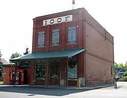 |
(#94000810) |
190 Main St. 45°46′03″N 118°33′48″W / 45.76746667°N 118.5633278°W |
Adams | |
| 2 | Arlington Hotel | _(umaDA0077).jpg) |
(#97000897) |
131 W. Main St. 45°44′33″N 119°11′43″W / 45.7425°N 119.195278°W |
Echo | |
| 3 | Bank of Echo Building | 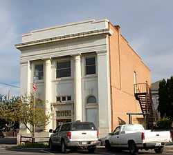 |
(#82003747) |
230 W. Main St. 45°44′33″N 119°11′39″W / 45.7425°N 119.194167°W |
Echo | |
| 4 | Bowman Hotel | 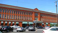 |
(#80003381) |
17 SW Frazer Ave. 45°40′12″N 118°47′11″W / 45.669936°N 118.786398°W |
Pendleton | |
| 5 | Central School | 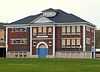 |
(#10000849) |
306 SW 2nd Ave. 45°55′59″N 118°23′26″W / 45.933056°N 118.390556°W |
Milton-Freewater | |
| 6 | William J. and Lodema Clarke House |  |
(#97000576) |
203 NW Despain Ave. 45°40′30″N 118°47′22″W / 45.674868°N 118.789485°W |
Pendleton | |
| 7 | Columbia College | 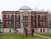 |
(#03001481) |
722 S. Main St. 45°55′43″N 118°23′07″W / 45.928717°N 118.385292°W |
Milton-Freewater | |
| 8 | Joseph Cunha Farmstead | 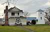 |
(#97000898) |
33263 Oregon Trail Rd. 45°44′29″N 119°12′05″W / 45.741389°N 119.201389°W |
Echo | |
| 9 | Echo City Hall | 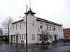 |
(#97000899) |
20 S. Bonanza St. 45°44′31″N 119°11′39″W / 45.741944°N 119.194167°W |
Echo | |
| 10 | Echo Methodist Church | 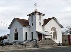 |
(#97000900) |
1 N. Bonanza St. 45°44′34″N 119°11′41″W / 45.742820°N 119.194839°W |
Echo | Originally built in 1886 a simple New England vernacular style, this church was expanded and transformed into the Gothic Revival style in 1910. It is the best example of Gothic Revival construction in the Echo area.[7] |
| 11 | James Edwards Building | 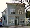 |
(#97000901) |
320 W. Main St. 45°44′32″N 119°11′34″W / 45.742222°N 119.192778°W |
Echo | |
| 12 | Ellis–Hampton House | 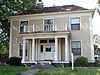 |
(#86002909) |
711 SE Byers Ave. 45°40′31″N 118°46′48″W / 45.675324°N 118.779983°W |
Pendleton | |
| 13 | Empire Block | 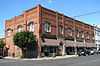 |
(#82003748) |
21–37 SW Emigrant Ave. 45°40′14″N 118°47′13″W / 45.670563°N 118.787007°W |
Pendleton | |
| 14 | Williams Frazier Farmstead | _(umaDA0044a).jpg) |
(#86001234) |
1403 Chestnut St. 45°55′24″N 118°22′36″W / 45.923333°N 118.376667°W |
Milton-Freewater | |
| 15 | Greasewood Finnish Apostolic Lutheran Church | 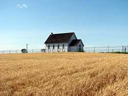 |
(#88001041) |
Finn Rd. at Finland Cemetery Rd. 45°46′32″N 118°39′47″W / 45.775556°N 118.663056°W |
Adams | |
| 16 | Hamley and Company Leather Goods Store | 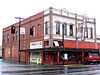 |
(#82003749) |
30 SE Court Ave. 45°40′22″N 118°47′12″W / 45.672683°N 118.786613°W |
Pendleton | |
| 17 | Hendricks Building (K.O.T.M.) | _(umaDA0014a).jpg) |
(#82003750) |
369 S. Main St. 45°40′14″N 118°47′12″W / 45.670652°N 118.786627°W |
Pendleton | |
| 18 | Sarah E. Ireland House | 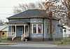 |
(#93001500) |
311 S. Main St. 45°55′56″N 118°23′10″W / 45.932222°N 118.386111°W |
Milton-Freewater | |
| 19 | Johnson–Ellis House | 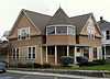 |
(#86000347) |
326 SE 2nd St. 45°40′19″N 118°47′04″W / 45.671923°N 118.784454°W |
Pendleton | |
| 20 | J. H. Koontz Building | 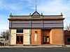 |
(#97000902) |
111 W. Main St. 45°44′33″N 119°11′44″W / 45.7425°N 119.195556°W |
Echo | |
| 21 | James H. and Cynthia Koontz House | 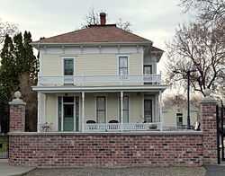 |
(#97000903) |
210 N. Dupont St. 45°44′41″N 119°11′44″W / 45.744722°N 119.195556°W |
Echo | |
| 22 | LaDow Block | 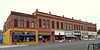 |
(#92001381) |
201–239 SE Court Ave. 45°40′25″N 118°47′07″W / 45.673566°N 118.785274°W |
Pendleton | |
| 23 | Masonic Temple | .jpg) |
(#82003751) |
18 SW Emigrant Ave. 45°40′13″N 118°47′11″W / 45.670397°N 118.786454°W |
Pendleton | |
| 24 | Matlock–Brownfield Building | 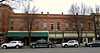 |
(#82003752) |
413–425 S. Main St. 45°40′13″N 118°47′11″W / 45.670206°N 118.786339°W |
Pendleton | |
| 25 | Meacham Hotel | 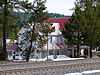 |
(#01000830) |
Main St. 45°30′28″N 118°25′10″W / 45.507778°N 118.419444°W |
Meacham | |
| 26 | Milarkey Building | 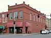 |
(#82003753) |
203 S. Main St. 45°40′21″N 118°47′16″W / 45.672459°N 118.787762°W |
Pendleton | |
| 27 | Reese and Redman General Merchandise Store | 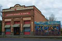 |
(#94000811) |
130 S. Main St. 45°45′59″N 118°33′44″W / 45.766389°N 118.562222°W |
Adams | |
| 28 | St. Peter's Roman Catholic Church | 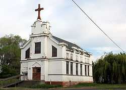 |
(#97000905) |
Junction of Marble St. and Leezer Ave. 45°44′23″N 119°12′05″W / 45.739818°N 119.201365°W |
Echo | |
| 29 | Isham Saling House | 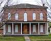 |
(#76001590) |
314 N. Water St. 45°49′01″N 118°25′26″W / 45.816944°N 118.423889°W |
Weston | |
| 30 | Edgar Sommerville House | _(umaDA0001).jpg) |
(#80003382) |
104 SE 5th St. 45°40′29″N 118°46′58″W / 45.674689°N 118.782779°W |
Pendleton | |
| 31 | South Main Street Commercial Historic District |  |
(#86003260) |
Roughly bounded by Dorion Ave., SE 1st St., Union Pacific Railroad, and SW 2nd St. 45°40′14″N 118°47′10″W / 45.670630°N 118.786230°W |
Pendleton | |
| 32 | Still–Perkins House | 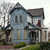 |
(#93000925) |
112 SE 6th Ave. 45°55′49″N 118°22′59″W / 45.930278°N 118.383056°W |
Milton-Freewater | |
| 33 | Umatilla County Library | 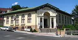 |
(#97000848) |
214 N. Main St. 45°40′28″N 118°47′19″W / 45.674504°N 118.788633°W |
Pendleton | |
| 34 | Umatilla Masonic Lodge Hall | 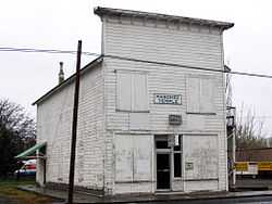 |
(#97000906) |
200 S. Dupont St. 45°44′31″N 119°11′43″W / 45.741944°N 119.195278°W |
Echo | |
| 35 | Umatilla Site (35UM1) | Upload image | (#81000522) |
Address restricted[8] |
Umatilla | The prehistoric component of this archeological site dates to 470 BCE and earlier, and may represent the largest such site in Oregon. Remains found include pit houses, stone and bone art objects, burials, and extensive animal remains, and are associated with the origins of seasonal sedentism around fishing opportunities. The site may also yield useful evidence of the historical period of the town of Umatilla.[9] |
| 36 | U.S. Post Office and Courthouse | _(umaDA0156).jpg) |
(#85000544) |
104 SW Dorion Ave. 45°40′16″N 118°47′17″W / 45.671002°N 118.788059°W |
Pendleton | |
| 37 | Joseph Vey House | 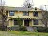 |
(#86000299) |
1304 SE Court Pl. 45°40′25″N 118°46′20″W / 45.673495°N 118.772185°W |
Pendleton | |
| 38 | Walla Walla Valley Traction Company Passenger Station and Powerhouse | 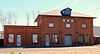 |
(#93000926) |
403 Robbins St. 45°56′26″N 118°23′46″W / 45.940470°N 118.396200°W |
Milton-Freewater | |
| 39 | M. L. Watts House | 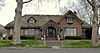 |
(#88000090) |
4th at Jefferson St. 45°48′47″N 118°29′16″W / 45.813056°N 118.487778°W |
Athena | |
| 40 | Weston Commercial Historic District | 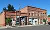 |
(#82001515) |
E. Main St. between Water and Broad St. 45°48′49″N 118°25′27″W / 45.813609°N 118.424080°W |
Weston | |
| 41 | Weston School |  |
(#11000976) |
205 E. Wallace St. 45°48′44″N 118°25′24″W / 45.812122°N 118.423211°W |
Weston | |
| 42 | Winn Barn | 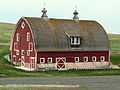 |
(#11000977) |
79560 Winn Rd. 45°50′25″N 118°24′19″W / 45.840353°N 118.405303°W |
Weston vicinity |
See also
- National Register of Historic Places listings in Oregon
- Listings in neighboring counties: Benton, Columbia, Grant, Morrow, Union, Walla Walla, Wallowa
- Historic preservation
- History of Oregon
- Lists of Oregon-related topics
References
- ↑ Andrus, Patrick W.; Shrimpton, Rebecca H. et al. (2002), How to Apply the National Register Criteria for Evaluation, National Register Bulletin (15), National Park Service, U.S. Department of the Interior, retrieved June 20, 2014 .
- ↑ National Park Service, National Register of Historic Places Program: Research, retrieved January 28, 2015.
- ↑ Oregon Parks and Recreation Department, Oregon Historic Sites Database, retrieved July 26, 2014. Note that a simple count of National Register records in this database returns a slightly higher total than actual listings, due to duplicate records. A close reading of detailed query results is necessary to arrive at the precise count.
- ↑ "National Register of Historic Places: Weekly List Actions". National Park Service, United States Department of the Interior. Retrieved on May 1, 2015.
- ↑ Numbers represent an ordering by significant words. Various colorings, defined here, differentiate National Historic Landmarks and historic districts from other NRHP buildings, structures, sites or objects.
- ↑ The eight-digit number below each date is the number assigned to each location in the National Register Information System database, which can be viewed by clicking the number.
- ↑ Donovan, Sally; Kadas, Marianne (December 15, 1996), National Register of Historic Places Registration Form: Echo Methodist Episcopal Church (PDF), retrieved December 2, 2014.
- ↑ Federal and state laws and practices restrict general public access to information regarding the specific location of sensitive archeological sites in many instances. The main reasons for such restrictions include the potential for looting, vandalism, or trampling. See: Knoerl, John; Miller, Diane; Shrimpton, Rebecca H. (1990), Guidelines for Restricting Information about Historic and Prehistoric Resources, National Register Bulletin (29), National Park Service, U.S. Department of the Interior, OCLC 20706997.
- ↑ Schalk, Randall (January 4, 1980), National Register of Historic Places Inventory — Nomination Form for Federal Properties: Old Umatilla.
External links
- Oregon Parks and Recreation Department, National Register Program
- National Park Service, National Register of Historic Places site
 Media related to National Register of Historic Places in Umatilla County, Oregon at Wikimedia Commons

| ||||||||||||||||||||||||||
| |||||||||||||||||||||||||||||