National Register of Historic Places listings in Uintah County, Utah
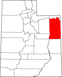
Location of Uintah County in Utah
This is a list of the National Register of Historic Places listings in Uintah County, Utah.
This is intended to be a complete list of the properties and districts on the National Register of Historic Places in Uintah County, Utah, United States. Latitude and longitude coordinates are provided for many National Register properties and districts; these locations may be seen together in a Google map.[1]
There are 19 properties and districts listed on the National Register in the county, including 2 National Historic Landmarks.
- This National Park Service list is complete through NPS recent listings posted May 1, 2015.[2]
Current listings
| [3] |
Name on the Register[4] |
Image |
Date listed[5] |
Location |
City or town |
Description |
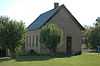
|---|
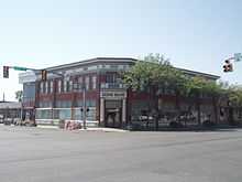
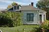
| 1 |
Bank of Vernal |
|
02008-12-04-0000December 4, 2008
(#08001155) |
3 W. Main St.
40°27′21″N 109°31′43″W / 40.4557°N 109.52855°W / 40.4557; -109.52855 (Bank of Vernal) |
Vernal |
|
| 2 |
Carter Road |
Upload image |
02001-05-21-0000May 21, 2001
(#00000354) |
Ashley National Forest
40°43′11″N 109°43′10″W / 40.719722°N 109.719444°W / 40.719722; -109.719444 (Carter Road) |
Ashley National Forest |
|
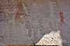
| 3 |
Cockleburr Wash Petroglyphs |
|
01980-09-04-0000September 4, 1980
(#80003974) |
Address Restricted[6]
|
Jensen |
|
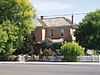
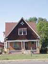
| 4 |
Lewis Curry House |
|
01982-07-26-0000July 26, 1982
(#82004166) |
189 S. Vernal Ave.
40°26′39″N 109°31′39″W / 40.444167°N 109.5275°W / 40.444167; -109.5275 (Lewis Curry House) |
Vernal |
|
| 5 |
Desolation Canyon |
|
01968-11-24-0000November 24, 1968
(#68000057) |
Along the Green River in western Uintah County between Ouray and Green River, about twice as close to Ouray[7]
39°30′01″N 110°01′19″W / 39.500278°N 110.021944°W / 39.500278; -110.021944 (Desolation Canyon) |
Ouray |
Split between Emery, Grand, Carbon, and Uintah counties
|
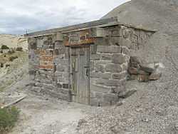
| 6 |
Earl Douglass Workshop-Laboratory |
|
01986-12-19-0000December 19, 1986
(#86003400) |
U.S. Route 40
40°26′26″N 109°18′04″W / 40.440556°N 109.301111°W / 40.440556; -109.301111 (Earl Douglass Workshop-Laboratory) |
Dinosaur National Monument |
|
| 7 |
Fenn-Bullock House |
|
01999-03-25-0000March 25, 1999
(#99000401) |
388 W. 100 North
40°27′26″N 109°32′07″W / 40.457222°N 109.535278°W / 40.457222; -109.535278 (Fenn-Bullock House) |
Vernal |
|
| 8 |
Gibson-Sowards House |
|
01997-11-24-0000November 24, 1997
(#97001465) |
3110 N. 250 West
40°30′05″N 109°31′59″W / 40.501389°N 109.533056°W / 40.501389; -109.533056 (Gibson-Sowards House) |
Vernal |
|
| 9 |
Little Brush Creek Petroglyphs |
|
01976-03-15-0000March 15, 1976
(#76001837) |
Address Restricted[6]
|
Vernal |
|
| 10 |
Manfred and Ethel Martin House |
|
02004-12-29-0000December 29, 2004
(#04001422) |
163 N. Vernal Ave.
40°27′28″N 109°31′41″W / 40.457778°N 109.528056°W / 40.457778; -109.528056 (Manfred and Ethel Martin House) |
Vernal |
|
| 11 |
McConkie Ranch Petroglyphs |
|
01975-09-25-0000September 25, 1975
(#75001828) |
Southeast of Dry Fork
40°32′55″N 109°38′17″W / 40.548611°N 109.638056°W / 40.548611; -109.638056 (McConkie Ranch Petroglyphs) |
Vernal |
|
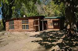
| 12 |
Josie Bassett Morris Ranch Complex |
|
01986-12-19-0000December 19, 1986
(#86003394) |
U.S. Route 40
40°25′31″N 109°10′31″W / 40.425278°N 109.175278°W / 40.425278; -109.175278 (Josie Bassett Morris Ranch Complex) |
Dinosaur National Monument |
|
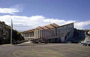
| 13 |
Quarry Visitor Center |
|
01986-12-19-0000December 19, 1986
(#86003401) |
U.S. Route 40
40°26′33″N 109°18′05″W / 40.4425°N 109.301389°W / 40.4425; -109.301389 (Quarry Visitor Center) |
Dinosaur National Monument |
|
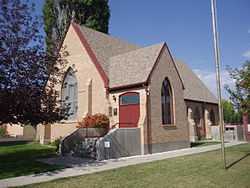
| 14 |
St. Paul's Episcopal Church and Lodge |
|
01985-01-03-0000January 3, 1985
(#85000049) |
226 W. Main St.
40°27′21″N 109°31′57″W / 40.455833°N 109.5325°W / 40.455833; -109.5325 (St. Paul's Episcopal Church and Lodge) |
Vernal |
|
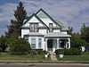
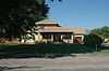
| 15 |
William and Emily Siddoway House |
|
02006-04-05-0000April 5, 2006
(#06000231) |
1055 N. Vernal Ave.
40°28′16″N 109°31′44″W / 40.471111°N 109.528889°W / 40.471111; -109.528889 (William and Emily Siddoway House) |
Vernal |
|
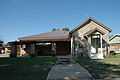
| 16 |
Francis 'Frank' and Eunice Smith House |
|
02001-03-29-0000March 29, 2001
(#01000317) |
1847 N. 3000 West
40°28′24″N 109°35′12″W / 40.473333°N 109.586667°W / 40.473333; -109.586667 (Francis 'Frank' and Eunice Smith House) |
Maeser |
|
| 17 |
Vernal Tithing Office |
|
01985-01-25-0000January 25, 1985
(#85000286) |
Northwestern corner of 500 West and 200 South
40°27′11″N 109°32′16″W / 40.453056°N 109.537778°W / 40.453056; -109.537778 (Vernal Tithing Office) |
Vernal |
|
| 18 |
Washington School-Vernal LDS Relief Society Hall |
|
02004-12-29-0000December 29, 2004
(#04001423) |
252 N. 500 West
40°27′34″N 109°32′13″W / 40.459444°N 109.536944°W / 40.459444; -109.536944 (Washington School-Vernal LDS Relief Society Hall) |
Vernal |
|
| 19 |
Whiterocks Village Site |
|
01976-01-01-0000January 1, 1976
(#76001838) |
Address Restricted[6]
|
Whiterocks |
|
See also
References
- ↑ The latitude and longitude information provided in this table was derived originally from the National Register Information System, which has been found to be fairly accurate for about 99% of listings. For about 1% of NRIS original coordinates, experience has shown that one or both coordinates are typos or otherwise extremely far off; some corrections may have been made. A more subtle problem causes many locations to be off by up to 150 yards, depending on location in the country: most NRIS coordinates were derived from tracing out latitude and longitudes off of USGS topographical quadrant maps created under the North American Datum of 1927, which differs from the current, highly accurate WGS84 GPS system used by most on-line maps. Chicago is about right, but NRIS longitudes in Washington are higher by about 4.5 seconds, and are lower by about 2.0 seconds in Maine. Latitudes differ by about 1.0 second in Florida. Some locations in this table may have been corrected to current GPS standards.
- ↑ "National Register of Historic Places: Weekly List Actions". National Park Service, United States Department of the Interior. Retrieved on May 1, 2015.
- ↑ Numbers represent an ordering by significant words. Various colorings, defined here, differentiate National Historic Landmarks and historic districts from other NRHP buildings, structures, sites or objects.
- ↑ "National Register Information System". National Register of Historic Places. National Park Service. 2008-04-24.
- ↑ The eight-digit number below each date is the number assigned to each location in the National Register Information System database, which can be viewed by clicking the number.
- ↑ 6.0 6.1 6.2 Some listings on the NRHP are highly sensitive sites and may be subject to looting or vandalism. The NRHP lists this site as "Address Restricted."
- ↑ Location and coordinates derived from its GNIS entry; the NRIS lists the site as "Address unknown"
External links
 Media related to National Register of Historic Places in Uintah County, Utah at Wikimedia Commons
|
|---|
| | Topics | |
|---|
| | Lists by states | |
|---|
| | Lists by insular areas | |
|---|
| | Lists by associated states | |
|---|
| | Other areas | |
|---|
|
-
 Category Category
-
 Portal Portal
-
 WikiProject WikiProject
|
|