National Register of Historic Places listings in Uinta County, Wyoming
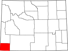
Location of Uinta County in Wyoming
This is a list of the National Register of Historic Places listings in Uinta County, Wyoming.
This is intended to be a complete list of the properties and districts on the National Register of Historic Places in Uinta County, Wyoming, United States. The locations of National Register properties and districts for which the latitude and longitude coordinates are included below, may be seen in a Google map.[1]
There are 13 properties and districts listed on the National Register in the county.
- This National Park Service list is complete through NPS recent listings posted May 1, 2015.[2]
Current listings
| [3] |
Name on the Register |
Image |
Date listed[4] |
Location |
City or town |
Description |
|---|
| 1 |
Bridger Antelope Trap |
Upload image |
01971-01-21-0000January 21, 1971
(#71000893) |
Address Restricted
|
Evanston |
|
| 2 |
Downtown Evanston Historic District |
|
01983-11-25-0000November 25, 1983
(#83004307) |
Roughly bounded by Center, 9th, 11th, and Front Sts.
41°16′04″N 110°57′53″W / 41.267778°N 110.964722°W / 41.267778; -110.964722 (Downtown Evanston Historic District) |
Evanston |
|
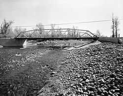
| 3 |
ERT Bridge over Black's Fork |
|
01985-02-22-0000February 22, 1985
(#85000441) |
County Road CN19-217
41°18′06″N 110°23′29″W / 41.301667°N 110.391389°W / 41.301667; -110.391389 (ERT Bridge over Black's Fork) |
Fort Bridger |
|
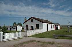
| 4 |
Fort Bridger |
|
01969-04-16-0000April 16, 1969
(#69000197) |
On Black's Fork of the Green River, near Fort Bridger
41°19′00″N 110°23′30″W / 41.316667°N 110.391667°W / 41.316667; -110.391667 (Fort Bridger) |
Fort Bridger |
|
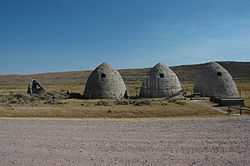
| 5 |
Piedmont Charcoal Kilns |
|
01971-06-03-0000June 3, 1971
(#71000894) |
14 mi (23 km) northeast of Hilliard
41°13′11″N 110°37′07″W / 41.219722°N 110.618611°W / 41.219722; -110.618611 (Piedmont Charcoal Kilns) |
Hilliard |
|
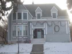
| 6 |
A. V. Quinn House |
|
01984-09-13-0000September 13, 1984
(#84003712) |
1049 Center St.
41°16′03″N 110°58′01″W / 41.2675°N 110.966944°W / 41.2675; -110.966944 (A. V. Quinn House) |
Evanston |
|
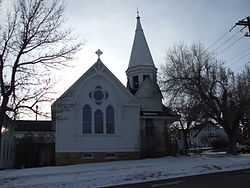
| 7 |
St. Paul's Episcopal Church |
|
01980-11-17-0000November 17, 1980
(#80004057) |
10th and Sage Sts.
41°15′57″N 110°58′01″W / 41.265833°N 110.966944°W / 41.265833; -110.966944 (St. Paul's Episcopal Church) |
Evanston |
|
| 8 |
Triangulation Point Draw Site District (48UT114; 48UT377; 48UT392; 48UT440) |
Upload image |
01986-09-16-0000September 16, 1986
(#86002320) |
Address Restricted
|
Verne |
|
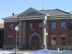
| 9 |
Uinta County Courthouse |
|
01977-07-14-0000July 14, 1977
(#77001385) |
Courthouse Sq.
41°15′59″N 110°57′50″W / 41.266389°N 110.963889°W / 41.266389; -110.963889 (Uinta County Courthouse) |
Evanston |
|
| 10 |
Union Pacific Railroad Complex |
|
01985-02-26-0000February 26, 1985
(#85000685) |
Main and 15th Sts.
41°16′16″N 110°58′09″W / 41.271111°N 110.969167°W / 41.271111; -110.969167 (Union Pacific Railroad Complex) |
Evanston |
|
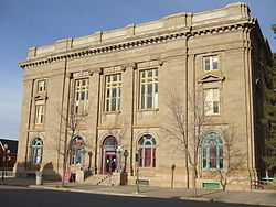
| 11 |
US Post Office-Evanston Main |
|
01987-05-19-0000May 19, 1987
(#87000790) |
221 10th St.
41°16′02″N 110°57′56″W / 41.267222°N 110.965556°W / 41.267222; -110.965556 (US Post Office-Evanston Main) |
Evanston |
|
| 12 |
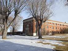
Wyoming State Insane Asylum |
|
02003-02-27-0000February 27, 2003
(#03000084) |
831 Wyoming Highway 150 S.
41°15′48″N 110°56′58″W / 41.263333°N 110.949444°W / 41.263333; -110.949444 (Wyoming State Insane Asylum) |
Evanston |
|
| 13 |
Brigham Young Oil Well |
Upload image |
01985-04-25-0000April 25, 1985
(#85000872) |
Northeastern quarter of the northeastern quarter of Section 4, Township 13, Range 119[5]
41°08′15″N 110°50′10″W / 41.137500°N 110.836111°W / 41.137500; -110.836111 (Brigham Young Oil Well) |
Evanston |
|
See also
References
- ↑ The latitude and longitude information provided in this table was derived originally from the National Register Information System, which has been found to be fairly accurate for about 99% of listings. For about 1% of NRIS original coordinates, experience has shown that one or both coordinates are typos or otherwise extremely far off; some corrections may have been made. A more subtle problem causes many locations to be off by up to 150 yards, depending on location in the country: most NRIS coordinates were derived from tracing out latitude and longitudes off of USGS topographical quadrant maps created under the North American Datum of 1927, which differs from the current, highly accurate WGS84 GPS system used by most on-line maps. Chicago is about right, but NRIS longitudes in Washington are higher by about 4.5 seconds, and are lower by about 2.0 seconds in Maine. Latitudes differ by about 1.0 second in Florida. Some locations in this table may have been corrected to current GPS standards.
- ↑ "National Register of Historic Places: Weekly List Actions". National Park Service, United States Department of the Interior. Retrieved on May 1, 2015.
- ↑ Numbers represent an ordering by significant words. Various colorings, defined here, differentiate National Historic Landmarks and historic districts from other NRHP buildings, structures, sites or objects.
- ↑ The eight-digit number below each date is the number assigned to each location in the National Register Information System database, which can be viewed by clicking the number.
- ↑ Emmons, Samuel Franklin, and Edwin Clarence Eckel. Contributions to Economic Geology, 1905. United States Geological Survey Bulletin 285. Washington: GPO, 1906, 345.
|
|---|
| | Topics | |
|---|
| | Lists by states | |
|---|
| | Lists by insular areas | |
|---|
| | Lists by associated states | |
|---|
| | Other areas | |
|---|
|
-
 Category Category
-
 Portal Portal
-
 WikiProject WikiProject
|
|