National Register of Historic Places listings in Teller County, Colorado

Location of Teller County in Colorado
This is a list of the National Register of Historic Places listings in Teller County, Colorado. It is intended to be a complete list of the properties and districts on the National Register of Historic Places in Teller County, Colorado, United States. The locations of National Register properties and districts for which the latitude and longitude coordinates are included below, may be seen in a Google map.[1]
There are 10 properties and districts listed on the National Register in the county, including 1 National Historic Landmark.
- This National Park Service list is complete through NPS recent listings posted May 1, 2015.[2]
Listings county-wide
| [3] |
Name on the Register[4] |
Image |
Date listed[5] |
Location |
City or town |
Description |
|---|
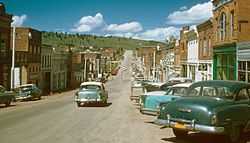
| 1 |
Cripple Creek Historic District |
|
01966-10-15-0000October 15, 1966
(#66000939) |
State Highway 67
38°45′07″N 105°10′31″W / 38.751944°N 105.175278°W / 38.751944; -105.175278 (Cripple Creek Historic District) |
Cripple Creek |
|
| 2 |
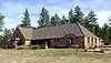
Florissant School |
|
01990-10-01-0000October 1, 1990
(#90001503) |
2009 County Road 31
38°56′54″N 105°17′41″W / 38.948333°N 105.294722°W / 38.948333; -105.294722 (Florissant School) |
Florissant |
|
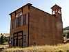
| 3 |
Goldfield City Hall and Fire Station |
|
01984-05-17-0000May 17, 1984
(#84000897) |
Victor Ave. and 9th St.
38°43′06″N 105°07′25″W / 38.718333°N 105.123611°W / 38.718333; -105.123611 (Goldfield City Hall and Fire Station) |
Goldfield |
|
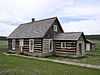
| 4 |
Hornbek House |
|
01981-12-08-0000December 8, 1981
(#81000105) |
County Road 1
38°55′34″N 105°16′56″W / 38.926111°N 105.282222°W / 38.926111; -105.282222 (Hornbek House) |
Florissant |
|
| 5 |
Manitou Experimental Forest Station |
|
01998-08-28-0000August 28, 1998
(#98001091) |
232 County Road 79
39°06′00″N 105°05′30″W / 39.1°N 105.091667°W / 39.1; -105.091667 (Manitou Experimental Forest Station) |
Woodland Park |
|
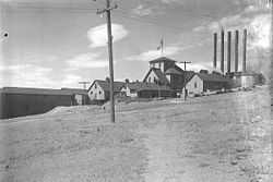
| 6 |
Midland Terminal Railroad Depot |
|
01984-05-17-0000May 17, 1984
(#84000899) |
230 N. 4th St.
38°42′45″N 105°08′25″W / 38.7125°N 105.140278°W / 38.7125; -105.140278 (Midland Terminal Railroad Depot) |
Victor |
|
| 7 |
Stratton's Independence Mine and Mill |
|
01993-03-04-0000March 4, 1993
(#93000054) |
Junction of Rangeview Rd. and State Highway 67
38°42′39″N 105°08′00″W / 38.710833°N 105.133333°W / 38.710833; -105.133333 (Stratton's Independence Mine and Mill) |
Victor |
|
| 8 |
Twin Creek Ranch |
Upload image |
01997-02-07-0000February 7, 1997
(#97000029) |
1465 Teller County Road 31
38°57′04″N 105°18′09″W / 38.951111°N 105.3025°W / 38.951111; -105.3025 (Twin Creek Ranch) |
Florissant |
|
| 9 |
Victor Downtown Historic District |
|
01985-07-03-0000July 3, 1985
(#85001463) |
Roughly bounded by Diamond Ave., 2nd, Portland, and 5th Sts.
38°42′39″N 105°08′25″W / 38.710833°N 105.140278°W / 38.710833; -105.140278 (Victor Downtown Historic District) |
Victor |
|
| 10 |
Victor Hotel |
|
01980-04-10-0000April 10, 1980
(#80000929) |
4th St. and Victor Ave.
38°42′38″N 105°08′26″W / 38.710556°N 105.140556°W / 38.710556; -105.140556 (Victor Hotel) |
Victor |
|
See also
References
- ↑ The latitude and longitude information provided in this table was derived originally from the National Register Information System, which has been found to be fairly accurate for about 99% of listings. For about 1% of NRIS original coordinates, experience has shown that one or both coordinates are typos or otherwise extremely far off; some corrections may have been made. A more subtle problem causes many locations to be off by up to 150 yards, depending on location in the country: most NRIS coordinates were derived from tracing out latitude and longitudes off of USGS topographical quadrant maps created under the North American Datum of 1927, which differs from the current, highly accurate WGS84 GPS system used by most on-line maps. Chicago is about right, but NRIS longitudes in Washington are higher by about 4.5 seconds, and are lower by about 2.0 seconds in Maine. Latitudes differ by about 1.0 second in Florida. Some locations in this table may have been corrected to current GPS standards.
- ↑ "National Register of Historic Places: Weekly List Actions". National Park Service, United States Department of the Interior. Retrieved on May 1, 2015.
- ↑ Numbers represent an ordering by significant words. Various colorings, defined here, differentiate National Historic Landmarks and historic districts from other NRHP buildings, structures, sites or objects.
- ↑ "National Register Information System". National Register of Historic Places. National Park Service. 2008-04-24.
- ↑ The eight-digit number below each date is the number assigned to each location in the National Register Information System database, which can be viewed by clicking the number.
|
|---|
| | Topics | |
|---|
| | Lists by states | |
|---|
| | Lists by insular areas | |
|---|
| | Lists by associated states | |
|---|
| | Other areas | |
|---|
|
-
 Category Category
-
 Portal Portal
-
 WikiProject WikiProject
|
|

.JPG)