National Register of Historic Places listings in Tehama County, California
This list includes properties and districts listed on the National Register of Historic Places in Tehama County, California. Click the "Map of all coordinates" link to the right to view a Google map of all properties and districts with latitude and longitude coordinates in the table below.[1]
-
- This National Park Service list is complete through NPS recent listings posted May 1, 2015.[2]
| [3] |
Name on the Register[4] |
Image |
Date listed[5] |
Location |
City or town |
Description |
|---|
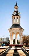
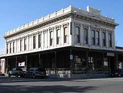
| 1 |
Cone and Kimball Building |
|
01979-06-26-0000June 26, 1979
(#79000564) |
747 Main St.
40°10′42″N 122°14′05″W / 40.178333°N 122.234722°W / 40.178333; -122.234722 (Cone and Kimball Building) |
Red Bluff |
|
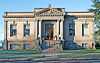
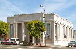
| 2 |
Herbert Kraft Memorial Free Library |
|
02000-04-14-0000April 14, 2000
(#00000362) |
909 Jefferson
40°10′43″N 122°14′16″W / 40.178611°N 122.237778°W / 40.178611; -122.237778 (Herbert Kraft Memorial Free Library) |
Red Bluff |
|
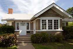
| 3 |
Maywood Woman's Club |
|
01992-10-02-0000October 2, 1992
(#92001301) |
902 Marin St.
39°55′38″N 122°10′34″W / 39.927222°N 122.176111°W / 39.927222; -122.176111 (Maywood Woman's Club) |
Corning |
|
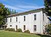
| 4 |
Molino Lodge Building |
|
01980-06-06-0000June 6, 1980
(#80000874) |
3rd and C Sts.
40°01′39″N 122°06′43″W / 40.0275°N 122.111944°W / 40.0275; -122.111944 (Molino Lodge Building) |
Tehama |
|
| 5 |
Odd Fellows Building |
|
01976-12-12-0000December 12, 1976
(#76000537) |
342 Oak St.
40°10′36″N 122°14′03″W / 40.176667°N 122.234167°W / 40.176667; -122.234167 (Odd Fellows Building) |
Red Bluff |
|
| 6 |
Old Bank of America Building |
|
01980-07-28-0000July 28, 1980
(#80000873) |
710 Main St.
40°10′41″N 122°14′02″W / 40.178056°N 122.233889°W / 40.178056; -122.233889 (Old Bank of America Building) |
Red Bluff |
|
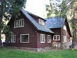
| 7 |
Park Headquarters, Lassen Volcanic National Park |
|
01978-10-03-0000October 3, 1978
(#06000490) |
Off CA 36
40°20′45″N 121°36′27″W / 40.345833°N 121.6075°W / 40.345833; -121.6075 (Park Headquarters, Lassen Volcanic National Park) |
Mineral |
|
| 8 |
Saint Mary's Parish |
|
01982-02-04-0000February 4, 1982
(#82002278) |
515 Main St.
40°10′32″N 122°13′58″W / 40.175556°N 122.232778°W / 40.175556; -122.232778 (Saint Mary's Parish) |
Red Bluff |
|
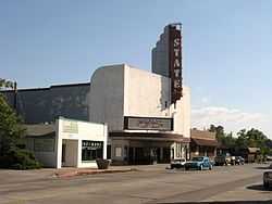
| 9 |
State Theatre |
|
02002-04-17-0000April 17, 2002
(#02000372) |
333 Oak St.
40°10′35″N 122°14′03″W / 40.176389°N 122.234167°W / 40.176389; -122.234167 (State Theatre) |
Red Bluff |
|
| 10 |
Sulphur Creek Archeological District |
Upload image |
01980-04-14-0000April 14, 1980
(#80000370) |
Address Restricted
|
Mill Creek |
|
See also
References
- ↑ The latitude and longitude information provided in this table was derived originally from the National Register Information System, which has been found to be fairly accurate for about 99% of listings. For about 1% of NRIS original coordinates, experience has shown that one or both coordinates are typos or otherwise extremely far off; some corrections may have been made. A more subtle problem causes many locations to be off by up to 150 yards, depending on location in the country: most NRIS coordinates were derived from tracing out latitude and longitudes off of USGS topographical quadrant maps created under the North American Datum of 1927, which differs from the current, highly accurate WGS84 GPS system used by most on-line maps. Chicago is about right, but NRIS longitudes in Washington are higher by about 4.5 seconds, and are lower by about 2.0 seconds in Maine. Latitudes differ by about 1.0 second in Florida. Some locations in this table may have been corrected to current GPS standards.
- ↑ "National Register of Historic Places: Weekly List Actions". National Park Service, United States Department of the Interior. Retrieved on May 1, 2015.
- ↑ Numbers represent an ordering by significant words. Various colorings, defined here, differentiate National Historic Landmarks and historic districts from other NRHP buildings, structures, sites or objects.
- ↑ "National Register Information System". National Register of Historic Places. National Park Service. 2008-04-24.
- ↑ The eight-digit number below each date is the number assigned to each location in the National Register Information System database, which can be viewed by clicking the number.
|
|---|
| | Topics | |
|---|
| | Lists by states | |
|---|
| | Lists by insular areas | |
|---|
| | Lists by associated states | |
|---|
| | Other areas | |
|---|
|
-
 Category Category
-
 Portal Portal
-
 WikiProject WikiProject
|
|