| [2] |
Name on the Register[3] |
Image |
Date listed[4] |
Location |
City or town |
Description |
|---|
| 1 |
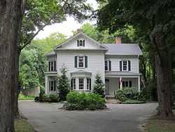
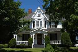
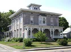
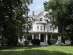
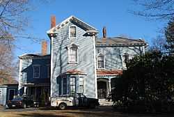
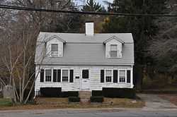
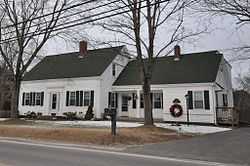
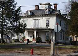
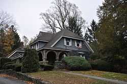
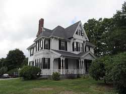
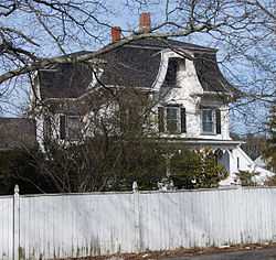
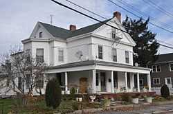
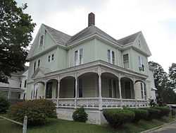
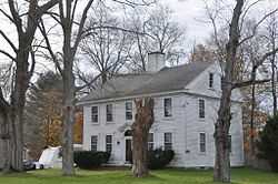
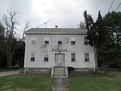
Charles R. Atwood House |
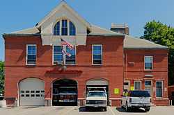
|
01984-07-05-0000July 5, 1984
(#84002087) |
30 Dean St.
41°54′14″N 71°04′59″W / 41.903889°N 71.083056°W / 41.903889; -71.083056 (Charles R. Atwood House) |
Taunton |
|
| 2 |
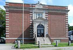
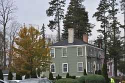
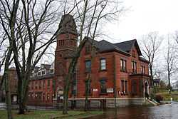
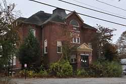
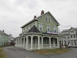
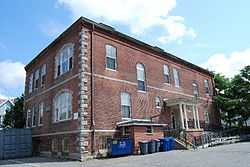
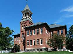
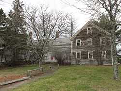
Barnum School |
|
01984-07-05-0000July 5, 1984
(#84002088) |
Barnum St.
41°53′40″N 71°05′45″W / 41.894444°N 71.095833°W / 41.894444; -71.095833 (Barnum School) |
Taunton |
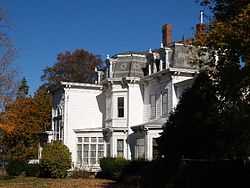
|
| 3 |
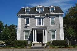
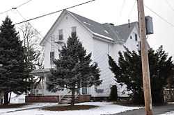
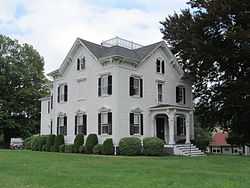
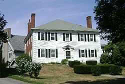
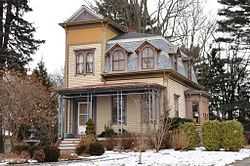
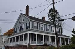
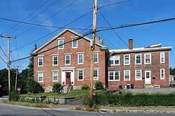
J.C. Bartlett House |
|
01984-07-05-0000July 5, 1984
(#84002089) |
12 Walnut St.
41°53′47″N 71°05′50″W / 41.896389°N 71.097222°W / 41.896389; -71.097222 (J.C. Bartlett House) |
Taunton |
|
| 4 |
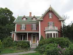
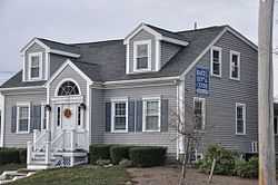
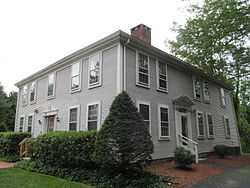
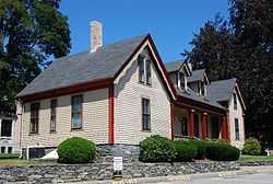
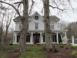
C.J.H. Bassett House |
|
01984-07-05-0000July 5, 1984
(#84002091) |
20 Chestnut St.
41°54′12″N 71°05′25″W / 41.903333°N 71.090278°W / 41.903333; -71.090278 (C.J.H. Bassett House) |
Taunton |
|
| 5 |
W.C. Beattie House |
|
01984-07-05-0000July 5, 1984
(#84002092) |
289 W. Brittania St.
41°55′07″N 71°06′24″W / 41.918611°N 71.106667°W / 41.918611; -71.106667 (W.C. Beattie House) |
Taunton |
|
| 6 |
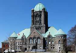
Bristol County Courthouse Complex |
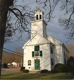
|
01978-03-28-0000March 28, 1978
(#78000427) |
9, 11, 15 Court St.
41°54′09″N 71°05′42″W / 41.9025°N 71.095°W / 41.9025; -71.095 (Bristol County Courthouse Complex) |
Taunton |
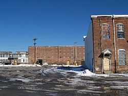
|
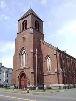
| 7 |
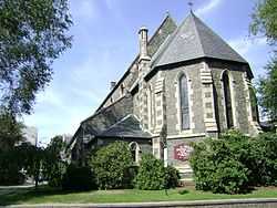
Brow's Tavern |
|
01984-07-05-0000July 5, 1984
(#84002094) |
211 Tremont St.
41°54′42″N 71°07′29″W / 41.911667°N 71.124722°W / 41.911667; -71.124722 (Brow's Tavern) |
Taunton |
|
| 8 |
Henry G. Brownell House |
|
01984-07-05-0000July 5, 1984
(#84002095) |
119 High St.
41°53′58″N 71°05′49″W / 41.899444°N 71.096944°W / 41.899444; -71.096944 (Henry G. Brownell House) |
Taunton |
Demolished, March 2014
|
| 9 |
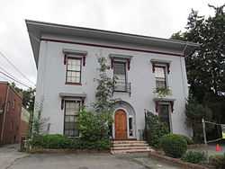
George Capron House |
|
01984-07-05-0000July 5, 1984
(#84002099) |
6 N. Pleasant St.
41°54′24″N 71°05′52″W / 41.906667°N 71.097778°W / 41.906667; -71.097778 (George Capron House) |
Taunton |
|
| 10 |
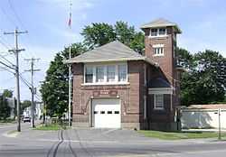
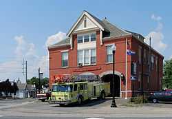
Central Fire Station |
|
01984-07-05-0000July 5, 1984
(#84002101) |
Leonard and School Sts.
41°54′14″N 71°05′32″W / 41.903889°N 71.092222°W / 41.903889; -71.092222 (Central Fire Station) |
Taunton |
3rd oldest occupied fire station in the nation
|
| 11 |
Church Green |
|
01977-12-16-0000December 16, 1977
(#77000168) |
U.S. 44 and MA 140
41°54′05″N 71°05′17″W / 41.901389°N 71.088056°W / 41.901389; -71.088056 (Church Green) |
Taunton |
|
| 12 |
Cohannet Mill No. 3 |
|
02006-11-29-0000November 29, 2006
(#06001088) |
120 Ingell St.
41°53′14″N 71°05′13″W / 41.887222°N 71.086944°W / 41.887222; -71.086944 (Cohannet Mill No. 3) |
Taunton |
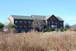
restored as Robertson on the River apartments
|
| 13 |
Samuel Colby House |
|
01984-07-05-0000July 5, 1984
(#84002103) |
74 Winthrop St.
41°53′50″N 71°05′55″W / 41.897222°N 71.098611°W / 41.897222; -71.098611 (Samuel Colby House) |
Taunton |
|
| 14 |
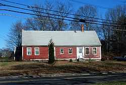
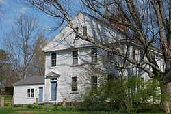
Abiezar Dean House |
|
01984-07-05-0000July 5, 1984
(#84002104) |
57 Summer St.
41°54′00″N 71°05′17″W / 41.9°N 71.0881°W / 41.9; -71.0881 (Abiezar Dean House) |
Taunton |
|
| 15 |
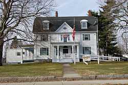
George Dean House |
|
01984-07-05-0000July 5, 1984
(#84002105) |
135 Winthrop St.
41°53′42″N 71°06′16″W / 41.895°N 71.1044°W / 41.895; -71.1044 (George Dean House) |
Taunton |
|
| 16 |
Jonathan Dean House |
Upload image |
01984-07-05-0000July 5, 1984
(#84002106) |
175 Dean St.
41°54′23″N 71°04′04″W / 41.9064°N 71.0678°W / 41.9064; -71.0678 (Jonathan Dean House) |
Taunton |
Demolished. Now the site of Rite Aid.
|
| 17 |
Lloyd Dean House |
|
01984-07-05-0000July 5, 1984
(#84002107) |
164 Dean St.
41°54′22″N 71°04′09″W / 41.9061°N 71.0692°W / 41.9061; -71.0692 (Lloyd Dean House) |
Taunton |
|
| 18 |
Theodore Dean House |
|
01984-07-05-0000July 5, 1984
(#84002108) |
26 Dean St.
41°54′13″N 71°05′02″W / 41.903611°N 71.083889°W / 41.903611; -71.083889 (Theodore Dean House) |
Taunton |
|
| 19 |
Dean-Barstow House |
|
01984-07-05-0000July 5, 1984
(#84002109) |
275 Williams St.
41°52′58″N 71°02′58″W / 41.882778°N 71.049444°W / 41.882778; -71.049444 (Dean-Barstow House) |
Taunton |
|
| 20 |
Dean-Hartshorn House |
|
01984-07-05-0000July 5, 1984
(#84002111) |
68 Dean St.
41°54′14″N 71°04′52″W / 41.903889°N 71.081111°W / 41.903889; -71.081111 (Dean-Hartshorn House) |
Taunton |
|
| 21 |
East Taunton Fire Station |
|
01984-07-05-0000July 5, 1984
(#84002112) |
Middleboro Ave.
41°52′56″N 71°02′01″W / 41.882222°N 71.033611°W / 41.882222; -71.033611 (East Taunton Fire Station) |
Taunton |
|
| 22 |
Eldridge House |
|
01984-07-05-0000July 5, 1984
(#84002114) |
172 County St.
41°53′45″N 71°04′38″W / 41.895833°N 71.077222°W / 41.895833; -71.077222 (Eldridge House) |
Taunton |
|
| 23 |
Fairbanks-Williams House |
|
01984-07-05-0000July 5, 1984
(#84002116) |
19 Elm St.
41°54′13″N 71°05′10″W / 41.903611°N 71.086111°W / 41.903611; -71.086111 (Fairbanks-Williams House) |
Taunton |
|
| 24 |
Albert Field Tack Company |
|
01984-07-05-0000July 5, 1984
(#84002117) |
19 Spring St.
41°53′57″N 71°05′29″W / 41.899167°N 71.091389°W / 41.899167; -71.091389 (Albert Field Tack Company) |
Taunton |
|
| 25 |
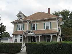
Fuller-Dauphin Estate |
|
01984-07-05-0000July 5, 1984
(#84002118) |
145 School St.
41°54′33″N 71°05′22″W / 41.909167°N 71.089444°W / 41.909167; -71.089444 (Fuller-Dauphin Estate) |
Taunton |
|
| 26 |
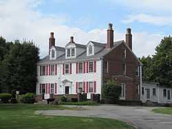
Gen. George Godfrey House |
|
01984-07-05-0000July 5, 1984
(#84002119) |
125 County St.
41°53′46″N 71°04′43″W / 41.896111°N 71.078611°W / 41.896111; -71.078611 (Gen. George Godfrey House) |
Taunton |
|
| 27 |
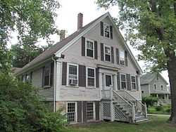
Richard Godfrey House |
|
01984-07-05-0000July 5, 1984
(#84002121) |
62 County St.
41°53′49″N 71°04′51″W / 41.8969°N 71.0808°W / 41.8969; -71.0808 (Richard Godfrey House) |
Taunton |
|
| 28 |
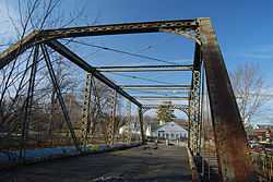
Harris Street Bridge |
|
01984-07-05-0000July 5, 1984
(#84002123) |
Spans Taunton River at Dean and Harris Sts.
41°54′20″N 71°04′12″W / 41.905556°N 71.07°W / 41.905556; -71.07 (Harris Street Bridge) |
Taunton |
|
| 29 |
Sarah A. Haskins House |
|
01984-07-05-0000July 5, 1984
(#84002124) |
18 Harrison St.
41°53′49″N 71°05′38″W / 41.896944°N 71.093889°W / 41.896944; -71.093889 (Sarah A. Haskins House) |
Taunton |
|
| 30 |
Higgins-Hodgeman House |
|
01984-07-05-0000July 5, 1984
(#84002128) |
19 Cedar St.
41°54′15″N 71°05′25″W / 41.904167°N 71.090278°W / 41.904167; -71.090278 (Higgins-Hodgeman House) |
Taunton |
|
| 31 |
Hodges House |
|
01984-07-05-0000July 5, 1984
(#84002130) |
41 Worcester St.
41°55′10″N 71°09′01″W / 41.919444°N 71.150278°W / 41.919444; -71.150278 (Hodges House) |
Taunton |
|
| 32 |
Hopewell Mills District |
|
01984-07-05-0000July 5, 1984
(#84002133) |
Bay St. and Albro Ave.
41°54′57″N 71°05′42″W / 41.915833°N 71.095°W / 41.915833; -71.095 (Hopewell Mills District) |
Taunton |
|
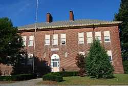
| 33 |
Hopewell School |
|
01984-07-05-0000July 5, 1984
(#84003859) |
Monroe St.
41°55′11″N 71°05′40″W / 41.919722°N 71.094444°W / 41.919722; -71.094444 (Hopewell School) |
Taunton |
|
| 34 |
Kilmer Street Fire Station |
|
01984-07-05-0000July 5, 1984
(#84002138) |
Oak and Kilmer Sts.
41°53′58″N 71°06′25″W / 41.899444°N 71.106944°W / 41.899444; -71.106944 (Kilmer Street Fire Station) |
Taunton |
|
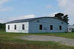
| 35 |
King Airfield Hangar |
|
01984-07-05-0000July 5, 1984
(#84002141) |
Middleboro Ave.
41°52′51″N 71°01′14″W / 41.880833°N 71.020556°W / 41.880833; -71.020556 (King Airfield Hangar) |
Taunton |
|
| 36 |
Job Knapp House |
|
01984-07-05-0000July 5, 1984
(#84002150) |
81 Shores St.
41°54′07″N 71°06′49″W / 41.901944°N 71.113611°W / 41.901944; -71.113611 (Job Knapp House) |
Taunton |
|
| 37 |
William Lawrence House |
|
01985-07-10-0000July 10, 1985
(#85001531) |
101 Somerset Ave.
41°53′36″N 71°05′36″W / 41.893333°N 71.093333°W / 41.893333; -71.093333 (William Lawrence House) |
Taunton |
|
| 38 |
Leonard School |
|
01984-07-05-0000July 5, 1984
(#84002155) |
W. Brittania St.
41°55′03″N 71°06′32″W / 41.9175°N 71.108889°W / 41.9175; -71.108889 (Leonard School) |
Taunton |
|
| 39 |
James Leonard House |
|
01984-07-05-0000July 5, 1984
(#84002152) |
3 Warren St.
41°54′51″N 71°06′28″W / 41.914167°N 71.107778°W / 41.914167; -71.107778 (James Leonard House) |
Taunton |
|
| 40 |
Ambrose Lincoln, Jr. House |
|
01984-07-05-0000July 5, 1984
(#84002157) |
1916 Bay St.
41°54′50″N 71°05′37″W / 41.913889°N 71.093611°W / 41.913889; -71.093611 (Ambrose Lincoln, Jr. House) |
Taunton |
|
| 41 |
Asa Lincoln House |
|
01984-07-05-0000July 5, 1984
(#84002159) |
171 Shores St.
41°54′03″N 71°07′29″W / 41.900833°N 71.124722°W / 41.900833; -71.124722 (Asa Lincoln House) |
Taunton |
|
| 42 |
Gen. Thomas Lincoln House |
|
01984-07-05-0000July 5, 1984
(#84002162) |
104 Field St.
41°57′24″N 71°05′56″W / 41.956667°N 71.098889°W / 41.956667; -71.098889 (Gen. Thomas Lincoln House) |
Taunton |
|
| 43 |
Lord-Baylies-Bennett House |
|
01984-07-05-0000July 5, 1984
(#84002165) |
66 Winthrop St.
41°53′52″N 71°05′50″W / 41.897778°N 71.097222°W / 41.897778; -71.097222 (Lord-Baylies-Bennett House) |
Taunton |
aka Masonic Lodge
|
| 44 |
Lothrop Memorial Building-G.A.R. Hall |
|
01984-07-05-0000July 5, 1984
(#84002168) |
Washington and Governor Sts.
41°54′13″N 71°06′29″W / 41.903611°N 71.108056°W / 41.903611; -71.108056 (Lothrop Memorial Building-G.A.R. Hall) |
Taunton |
|
| 45 |
H.B. Lothrop Store |
|
01984-07-05-0000July 5, 1984
(#84002166) |
210 Weir St.
41°53′46″N 71°06′14″W / 41.896111°N 71.103889°W / 41.896111; -71.103889 (H.B. Lothrop Store) |
Taunton |
|
| 46 |
Calvin T. Macomber House |
|
01984-07-05-0000July 5, 1984
(#84002174) |
312 W. Brittania St.
41°55′06″N 71°06′25″W / 41.918333°N 71.106944°W / 41.918333; -71.106944 (Calvin T. Macomber House) |
Taunton |
|
| 47 |
Theodore L. Marvel House |
|
01984-07-05-0000July 5, 1984
(#84002176) |
188 Berkley St.
41°52′46″N 71°05′23″W / 41.879444°N 71.089722°W / 41.879444; -71.089722 (Theodore L. Marvel House) |
Taunton |
|
| 48 |
N. S. Mason House |
|
01984-07-05-0000July 5, 1984
(#84002178) |
58 Tremont St.
41°54′18″N 71°06′24″W / 41.905°N 71.106667°W / 41.905; -71.106667 (N. S. Mason House) |
Taunton |
|
| 49 |
McKinstrey House |
|
01984-07-05-0000July 5, 1984
(#84002181) |
115 High St.
41°53′58″N 71°05′50″W / 41.899444°N 71.097222°W / 41.899444; -71.097222 (McKinstrey House) |
Taunton |
|
| 50 |
Morse House |
|
01984-07-05-0000July 5, 1984
(#84002185) |
6 Pleasant St.
41°54′14″N 71°05′41″W / 41.903889°N 71.094722°W / 41.903889; -71.094722 (Morse House) |
Taunton |
|
| 51 |
Henry Morse House |
|
01984-07-05-0000July 5, 1984
(#84002183) |
32 Cedar St.
41°54′13″N 71°05′26″W / 41.903611°N 71.090556°W / 41.903611; -71.090556 (Henry Morse House) |
Taunton |
|
| 52 |
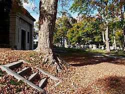
Mount Pleasant Cemetery |
|
02002-12-05-0000December 5, 2002
(#02001474) |
Crocker, Cohannet, and Barnum Sts.
41°53′42″N 71°05′59″W / 41.895°N 71.099722°W / 41.895; -71.099722 (Mount Pleasant Cemetery) |
Taunton |
|
| 53 |
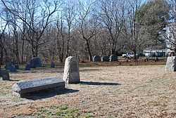
Neck of Land Cemetery |
|
01985-07-10-0000July 10, 1985
(#85001530) |
Summer St.
41°53′52″N 71°05′09″W / 41.897778°N 71.085833°W / 41.897778; -71.085833 (Neck of Land Cemetery) |
Taunton |
|
| 54 |
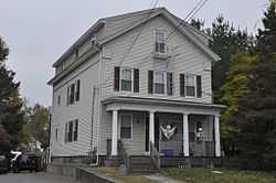
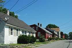
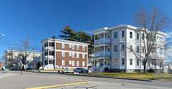
Thomas Nichols Three Deckers |
|
01984-07-05-0000July 5, 1984
(#84002097) |
68 and 80 88 W. Brittania St.
41°54′48″N 71°06′07″W / 41.913333°N 71.101944°W / 41.913333; -71.101944 (Thomas Nichols Three Deckers) |
Taunton |
Two historic triple-decker homes.
|
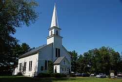
| 55 |
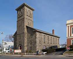
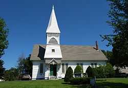
North Taunton Baptist Church |
|
01984-07-05-0000July 5, 1984
(#84002188) |
1940 Bay St.
41°54′52″N 71°05′41″W / 41.914444°N 71.094722°W / 41.914444; -71.094722 (North Taunton Baptist Church) |
Taunton |
|
| 56 |
Old Colony Iron Works-Nemasket Mills Complex |
|
01984-07-05-0000July 5, 1984
(#84002190) |
Old Colony Ave.
41°53′09″N 71°01′38″W / 41.885833°N 71.027222°W / 41.885833; -71.027222 (Old Colony Iron Works-Nemasket Mills Complex) |
Taunton |
|
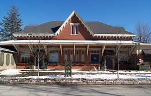
| 57 |
Old Colony Railroad Station |
|
01984-07-05-0000July 5, 1984
(#84002192) |
40 Dean St.
41°54′16″N 71°04′56″W / 41.904444°N 71.082222°W / 41.904444; -71.082222 (Old Colony Railroad Station) |
Taunton |
|
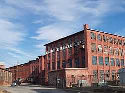
| 58 |
Old Weir Stove Company |
|
01984-07-05-0000July 5, 1984
(#84002194) |
W. Water St.
41°52′57″N 71°05′34″W / 41.8825°N 71.092778°W / 41.8825; -71.092778 (Old Weir Stove Company) |
Taunton |
|
| 59 |
Alfred Paull House |
|
01984-07-05-0000July 5, 1984
(#84002196) |
467 Weir St.
41°53′20″N 71°05′26″W / 41.888889°N 71.090556°W / 41.888889; -71.090556 (Alfred Paull House) |
Taunton |
|
| 60 |
Pilgrim Congregational Church |
|
01984-07-05-0000July 5, 1984
(#84002199) |
45 Broadway
41°54′14″N 71°05′39″W / 41.903889°N 71.094167°W / 41.903889; -71.094167 (Pilgrim Congregational Church) |
Taunton |
|
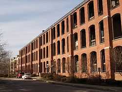
| 61 |
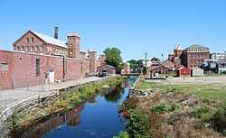
Reed and Barton Complex |
|
01984-07-05-0000July 5, 1984
(#84002207) |
W. Brittania and Danforth Sts.
41°55′05″N 71°06′06″W / 41.918056°N 71.101667°W / 41.918056; -71.101667 (Reed and Barton Complex) |
Taunton |
|
| 62 |
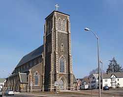
St. Mary's Complex |
|
01984-07-05-0000July 5, 1984
(#84002211) |
Broadway and Washington St.
41°54′27″N 71°05′39″W / 41.9075°N 71.094167°W / 41.9075; -71.094167 (St. Mary's Complex) |
Taunton |
|
| 63 |
St. Thomas Episcopal Church |
|
01984-07-05-0000July 5, 1984
(#84002213) |
115 High St.
41°53′50″N 71°05′27″W / 41.897222°N 71.090833°W / 41.897222; -71.090833 (St. Thomas Episcopal Church) |
Taunton |
|
| 64 |
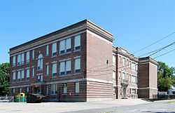
School Street School |
|
01984-07-05-0000July 5, 1984
(#84002214) |
School and Fruit Sts.
41°54′12″N 71°06′03″W / 41.903333°N 71.100833°W / 41.903333; -71.100833 (School Street School) |
Taunton |
|
| 65 |
Sylvanus N. Staples House |
|
01984-07-05-0000July 5, 1984
(#84002217) |
21 Second St.
41°53′11″N 71°05′37″W / 41.8864°N 71.0936°W / 41.8864; -71.0936 (Sylvanus N. Staples House) |
Taunton |
|
| 66 |
Stone House |
|
01984-07-05-0000July 5, 1984
(#84002219) |
15-17 Plain St.
41°53′05″N 71°05′17″W / 41.884722°N 71.088056°W / 41.884722; -71.088056 (Stone House) |
Taunton |
|
| 67 |
Albert Sweet House |
|
01984-07-05-0000July 5, 1984
(#84002221) |
179 Highland St.
41°53′34″N 71°06′58″W / 41.892778°N 71.116111°W / 41.892778; -71.116111 (Albert Sweet House) |
Taunton |
|
| 68 |
Taunton Alms House |
|
01984-07-05-0000July 5, 1984
(#84002223) |
Norton Ave.
41°55′07″N 71°07′57″W / 41.918611°N 71.1325°W / 41.918611; -71.1325 (Taunton Alms House) |
Taunton |
|
| 69 |
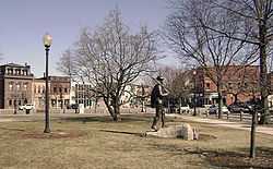
Taunton Green Historic District |
|
01985-03-01-0000March 1, 1985
(#85000547) |
Broadway, Taunton Green, Main and Court Sts.
41°54′08″N 71°05′40″W / 41.902222°N 71.094444°W / 41.902222; -71.094444 (Taunton Green Historic District) |
Taunton |
|
| 70 |
Taunton Public Library |
|
01984-07-05-0000July 5, 1984
(#84002225) |
Pleasant St.
41°54′12″N 71°05′41″W / 41.903333°N 71.094722°W / 41.903333; -71.094722 (Taunton Public Library) |
Taunton |
|
| 71 |
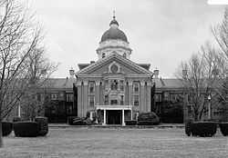
Taunton State Hospital |
|
01994-01-21-0000January 21, 1994
(#93001484) |
W bank of the Mill R. at Danforth St.
41°54′42″N 71°06′06″W / 41.911667°N 71.101667°W / 41.911667; -71.101667 (Taunton State Hospital) |
Taunton |
Partially destroyed by fire
|
| 72 |
H.P. Thomas House |
|
01984-07-05-0000July 5, 1984
(#84002228) |
322 Somerset Ave.
41°53′16″N 71°05′39″W / 41.887778°N 71.094167°W / 41.887778; -71.094167 (H.P. Thomas House) |
Taunton |
|
| 73 |
Tisdale-Morse House |
|
01984-07-05-0000July 5, 1984
(#84002231) |
17 Fayette Pl.
41°54′15″N 71°05′28″W / 41.904167°N 71.091111°W / 41.904167; -71.091111 (Tisdale-Morse House) |
Taunton |
|
| 74 |
Union Congregational Church |
|
01984-07-05-0000July 5, 1984
(#84002232) |
W. Brittania and Rockland Sts.
41°55′10″N 71°06′20″W / 41.919444°N 71.105556°W / 41.919444; -71.105556 (Union Congregational Church) |
Taunton |
|
| 75 |
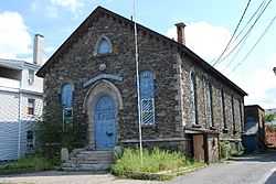
Union Mission Chapel-Historical Hall |
|
01984-07-05-0000July 5, 1984
(#84002235) |
Cedar St.
41°54′13″N 71°05′30″W / 41.903611°N 71.091667°W / 41.903611; -71.091667 (Union Mission Chapel-Historical Hall) |
Taunton |
|
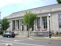
| 76 |
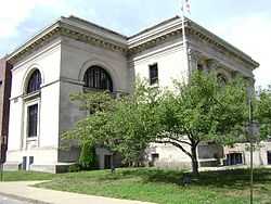
US Post Office-Taunton Main |
|
01987-10-19-0000October 19, 1987
(#86003476) |
37 Taunton Green
41°54′06″N 71°05′41″W / 41.901667°N 71.094722°W / 41.901667; -71.094722 (US Post Office-Taunton Main) |
Taunton |
|
| 77 |
Capt. David Vickery House |
|
01984-07-05-0000July 5, 1984
(#84002254) |
33 Plain St.
41°53′04″N 71°05′13″W / 41.884444°N 71.086944°W / 41.884444; -71.086944 (Capt. David Vickery House) |
Taunton |
|
| 78 |
Vickery-Baylies House |
|
01984-07-05-0000July 5, 1984
(#84002252) |
56 Summer St.
41°53′59″N 71°05′15″W / 41.899722°N 71.0875°W / 41.899722; -71.0875 (Vickery-Baylies House) |
Taunton |
|
| 79 |
Walker School |
|
01984-07-05-0000July 5, 1984
(#84002257) |
Berkley St.
41°52′56″N 71°03′11″W / 41.882222°N 71.053056°W / 41.882222; -71.053056 (Walker School) |
Taunton |
|
| 80 |
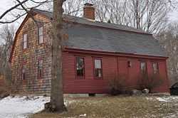
Peter Walker House |
|
01984-07-05-0000July 5, 1984
(#84002256) |
1679 Somerset Ave.
41°51′26″N 71°06′55″W / 41.8571°N 71.1154°W / 41.8571; -71.1154 (Peter Walker House) |
Taunton |
|
| 81 |
Samuel Washburn House |
|
01984-07-05-0000July 5, 1984
(#84002258) |
68 Winthrop St.
41°53′50″N 71°05′52″W / 41.897222°N 71.097778°W / 41.897222; -71.097778 (Samuel Washburn House) |
Taunton |
|
| 82 |
Washington School |
|
01984-07-05-0000July 5, 1984
(#84002261) |
40 Vernon St.
41°53′45″N 71°06′22″W / 41.895833°N 71.106111°W / 41.895833; -71.106111 (Washington School) |
Taunton |
|
| 83 |
Weir Engine House |
|
01984-07-05-0000July 5, 1984
(#84002263) |
530 Weir St.
41°53′15″N 71°05′23″W / 41.8875°N 71.089722°W / 41.8875; -71.089722 (Weir Engine House) |
Taunton |
|
| 84 |
Westville Congregational Church |
|
01984-07-05-0000July 5, 1984
(#84002266) |
Winthrop and N. Walker Sts.
41°53′08″N 71°08′17″W / 41.885556°N 71.138056°W / 41.885556; -71.138056 (Westville Congregational Church) |
Taunton |
|
| 85 |
William L. White, Jr. House |
|
01984-07-05-0000July 5, 1984
(#84002268) |
242 Winthrop St.
41°53′24″N 71°06′55″W / 41.89°N 71.115278°W / 41.89; -71.115278 (William L. White, Jr. House) |
Taunton |
|
| 86 |
Whittenton Fire and Police Station |
|
01984-07-05-0000July 5, 1984
(#84002271) |
Bay St.
41°55′14″N 71°05′49″W / 41.920556°N 71.096944°W / 41.920556; -71.096944 (Whittenton Fire and Police Station) |
Taunton |
|
| 87 |
Whittenton Mills Complex |
|
01984-07-05-0000July 5, 1984
(#84002275) |
Mill River and Whittenton St.
41°55′27″N 71°06′21″W / 41.924167°N 71.105833°W / 41.924167; -71.105833 (Whittenton Mills Complex) |
Taunton |
|
| 88 |
Abiathar King Williams House |
|
01984-07-05-0000July 5, 1984
(#84002278) |
43 Ingell St.
41°53′36″N 71°05′02″W / 41.893333°N 71.083889°W / 41.893333; -71.083889 (Abiathar King Williams House) |
Taunton |
|
| 89 |
Enoch Williams House |
|
01984-07-05-0000July 5, 1984
(#84002280) |
616 Middleboro Ave.
41°52′57″N 71°01′26″W / 41.8825°N 71.023889°W / 41.8825; -71.023889 (Enoch Williams House) |
Taunton |
|
| 90 |
Francis D. Williams House |
|
01984-07-05-0000July 5, 1984
(#84002282) |
3 Plain St.
41°53′07″N 71°05′21″W / 41.885278°N 71.089167°W / 41.885278; -71.089167 (Francis D. Williams House) |
Taunton |
|
| 91 |
N.S. Williams House |
|
01984-07-05-0000July 5, 1984
(#84002285) |
1150 Middleboro Ave.
41°52′55″N 71°00′03″W / 41.881944°N 71.000833°W / 41.881944; -71.000833 (N.S. Williams House) |
Taunton |
|
| 92 |
Joseph Willis House |
|
01984-07-05-0000July 5, 1984
(#84002286) |
28 Worcester St.
41°54′59″N 71°08′51″W / 41.916389°N 71.1475°W / 41.916389; -71.1475 (Joseph Willis House) |
Taunton |
|
| 93 |
Winslow Congregational Church |
Upload image |
01984-07-05-0000July 5, 1984
(#84002288) |
61 Winthrop St.
41°53′55″N 71°05′50″W / 41.898611°N 71.097222°W / 41.898611; -71.097222 (Winslow Congregational Church) |
Taunton |
Demolished late 1990s.
|
| 94 |
Winthrop Street Baptist Church |
|
01984-07-05-0000July 5, 1984
(#84002291) |
58 Winthrop St.
41°54′01″N 71°05′46″W / 41.900278°N 71.096111°W / 41.900278; -71.096111 (Winthrop Street Baptist Church) |
Taunton |
|
| 95 |
William Woodward House |
|
01985-07-10-0000July 10, 1985
(#85001529) |
117 Arlington St.
41°54′17″N 71°04′57″W / 41.904722°N 71.0825°W / 41.904722; -71.0825 (William Woodward House) |
Taunton |
|