| [3] |
Name on the Register[4] |
Image |
Date listed[5] |
Location |
City or town |
Description |
|---|
| 1 |
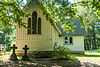
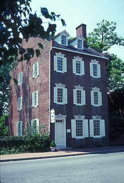
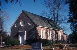
All Saints' Church |
|
01983-05-27-0000May 27, 1983
(#83002962) |
Maryland Route 662
38°50′46″N 76°04′53″W / 38.846111°N 76.081389°W / 38.846111; -76.081389 (All Saints' Church) |
Easton |
|
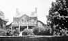
| 2 |
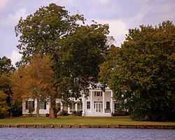
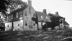
The Anchorage |
|
01974-07-30-0000July 30, 1974
(#74000968) |
Northwest of Easton off Maryland Route 370
38°47′41″N 76°07′49″W / 38.794722°N 76.130278°W / 38.794722; -76.130278 (The Anchorage) |
Easton |
|
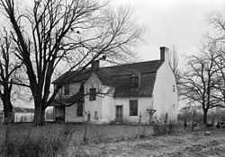
| 3 |
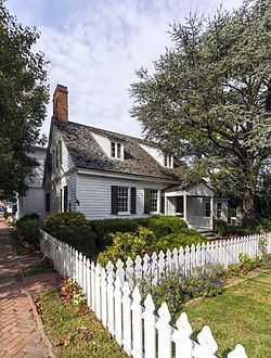
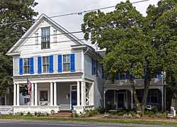
Barnaby House |
|
01992-11-24-0000November 24, 1992
(#92001228) |
212 N. Morris St.
38°41′26″N 76°10′25″W / 38.69061°N 76.17354°W / 38.69061; -76.17354 (Barnaby House) |
Oxford |
|
| 4 |
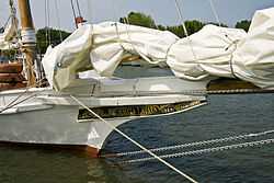
BILLIE P. HALL (log canoe) |
Upload image |
01985-09-18-0000September 18, 1985
(#85002251) |
Evergreen Rd.
38°40′27″N 76°08′25″W / 38.674167°N 76.140278°W / 38.674167; -76.140278 (BILLIE P. HALL (log canoe)) |
Oxford |
|
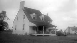
| 5 |
Cannonball House |
|
01980-12-03-0000December 3, 1980
(#80001839) |
200 Mulberry St.
38°47′03″N 76°13′22″W / 38.784167°N 76.222778°W / 38.784167; -76.222778 (Cannonball House) |
St. Michaels |
|
| 6 |
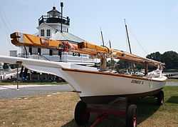
CLAUDE W. SOMERS |
Upload image |
01985-05-16-0000May 16, 1985
(#85001085) |
Old Ferry Terminal, Washington St.
38°50′11″N 76°16′51″W / 38.836389°N 76.280833°W / 38.836389; -76.280833 (CLAUDE W. SOMERS) |
Claiborne |
|
| 7 |
Clay's Hope |
Upload image |
01979-10-31-0000October 31, 1979
(#79001142) |
Bellevue Rd.
38°42′25″N 76°11′17″W / 38.706944°N 76.188056°W / 38.706944; -76.188056 (Clay's Hope) |
Bellevue |
|
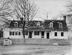
| 8 |
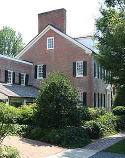
Compton |
Upload image |
01974-07-25-0000July 25, 1974
(#74000970) |
West of Trappe on Howell Point Rd.
38°38′27″N 76°06′25″W / 38.640833°N 76.106944°W / 38.640833; -76.106944 (Compton) |
Trappe |
|
| 9 |
Crooked Intention |
Upload image |
01974-07-24-0000July 24, 1974
(#74000969) |
West of Maryland Route 33
38°46′44″N 76°13′53″W / 38.778889°N 76.231389°W / 38.778889; -76.231389 (Crooked Intention) |
St. Michaels |
|
| 10 |
Doncaster Town Site |
Upload image |
01975-09-05-0000September 5, 1975
(#75000920) |
Buffs Island Rd., on the shores of Shaw Bay[6]
38°51′30″N 76°11′27″W / 38.858333°N 76.190833°W / 38.858333; -76.190833 (Doncaster Town Site) |
Easton |
|
| 11 |
E.C. COLLIER |
|
01985-05-16-0000May 16, 1985
(#85001087) |
Gibsontown Rd.
38°42′46″N 76°19′53″W / 38.712778°N 76.331389°W / 38.712778; -76.331389 (E.C. COLLIER) |
Tilghman |
|
| 12 |
Easton Historic District |
|
01980-09-17-0000September 17, 1980
(#80001835) |
Maryland Routes 328, 331, and 565
38°46′19″N 76°04′26″W / 38.771944°N 76.073889°W / 38.771944; -76.073889 (Easton Historic District) |
Easton |
|
| 13 |
EDMEE S. (log canoe) |
|
01985-09-18-0000September 18, 1985
(#85002258) |
Mill St.
38°47′15″N 76°13′09″W / 38.7875°N 76.219167°W / 38.7875; -76.219167 (EDMEE S. (log canoe)) |
St. Michaels |
|
| 14 |
EDNA E. LOCKWOOD (Chesapeake Bay bugeye) |
|
01986-02-13-0000February 13, 1986
(#86000258) |
Navy Point at the foot of Mill St.
38°47′15″N 76°13′10″W / 38.7875°N 76.219444°W / 38.7875; -76.219444 (EDNA E. LOCKWOOD (Chesapeake Bay bugeye)) |
St. Michaels |
|
| 15 |
FLYING CLOUD (log canoe) |
Upload image |
01985-09-18-0000September 18, 1985
(#85002263) |
Magee Rd.
38°46′48″N 76°17′23″W / 38.78°N 76.289722°W / 38.78; -76.289722 (FLYING CLOUD (log canoe)) |
Wittman |
|
| 16 |
HILDA M. WILLING |
|
01985-05-16-0000May 16, 1985
(#85001089) |
Gibsontown Rd.
38°42′46″N 76°19′53″W / 38.712778°N 76.331389°W / 38.712778; -76.331389 (HILDA M. WILLING) |
Tilghman |
|
| 17 |
Hope House |
|
01979-11-01-0000November 1, 1979
(#79001143) |
Northwest of Easton, northeast of Voit Rd., and 0.8 miles northwest of the bridge at Tunis Mill
38°50′01″N 76°11′10″W / 38.833611°N 76.186111°W / 38.833611; -76.186111 (Hope House) |
Easton |
|
| 18 |
ISLAND BIRD (log canoe) |
Upload image |
01985-09-18-0000September 18, 1985
(#85002254) |
Miles River Yacht Club
38°48′00″N 76°13′10″W / 38.8°N 76.219444°W / 38.8; -76.219444 (ISLAND BIRD (log canoe)) |
St. Michaels |
|
| 19 |
ISLAND BLOSSOM (log canoe) |
Upload image |
01985-09-18-0000September 18, 1985
(#85002255) |
Miles River Yacht Club
38°48′00″N 76°13′10″W / 38.8°N 76.219444°W / 38.8; -76.219444 (ISLAND BLOSSOM (log canoe)) |
St. Michaels |
|
| 20 |
ISLAND LARK (log canoe) |
Upload image |
01985-09-18-0000September 18, 1985
(#85002259) |
Carpenter St.
38°47′10″N 76°13′19″W / 38.786111°N 76.221944°W / 38.786111; -76.221944 (ISLAND LARK (log canoe)) |
St. Michaels |
|
| 21 |
JAY DEE (log canoe) |
Upload image |
01985-09-18-0000September 18, 1985
(#85002256) |
Miles River Yacht Club
38°48′00″N 76°13′10″W / 38.8°N 76.219444°W / 38.8; -76.219444 (JAY DEE (log canoe)) |
St. Michaels |
|
| 22 |
Jena |
|
01980-08-06-0000August 6, 1980
(#80001838) |
East of Oxford off Maryland Route 333
38°41′17″N 76°08′18″W / 38.688056°N 76.138333°W / 38.688056; -76.138333 (Jena) |
Oxford |
|
| 23 |
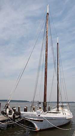
KATHRYN |
|
None
(#85001090) |
Dogwood Harbor
38°42′46″N 76°19′53″W / 38.712778°N 76.331389°W / 38.712778; -76.331389 (KATHRYN) |
Tilghman Island |
Listed twice in the NRIS: once simply as "KATHRYN", the other as "KATHRYN (Chesapeake Skipjack)"
|
| 24 |
Llandaff House |
Upload image |
02002-12-27-0000December 27, 2002
(#02001587) |
28472 Old Country Club Rd.
38°43′58″N 76°05′22″W / 38.732778°N 76.089444°W / 38.732778; -76.089444 (Llandaff House) |
Easton |
|
| 25 |
MAGGIE LEE |
Upload image |
01985-05-16-0000May 16, 1985
(#85001091) |
Gibsontown Rd.
38°42′46″N 76°19′53″W / 38.712778°N 76.331389°W / 38.712778; -76.331389 (MAGGIE LEE) |
Tilghman |
|
| 26 |
MAGIC (log canoe) |
Upload image |
01985-09-18-0000September 18, 1985
(#85002260) |
St. Michaels Marina
38°47′06″N 76°13′13″W / 38.785°N 76.220278°W / 38.785; -76.220278 (MAGIC (log canoe)) |
St. Michaels |
|
| 27 |
Miller's House |
Upload image |
02010-12-17-0000December 17, 2010
(#10001038) |
Old Wye Mills Rd.
38°54′57″N 76°04′33″W / 38.915833°N 76.075833°W / 38.915833; -76.075833 (Miller's House) |
Wye Mills vicinity |
|
| 28 |
MINNIE V |
Upload image |
01985-05-16-0000May 16, 1985
(#85001092) |
Gibsontown Rd.
38°42′46″N 76°19′53″W / 38.712778°N 76.331389°W / 38.712778; -76.331389 (MINNIE V) |
Tilghman |
|
| 29 |
Myrtle Grove |
Upload image |
01974-08-13-0000August 13, 1974
(#74000967) |
Goldsborough Neck Rd.
38°48′15″N 76°07′06″W / 38.804167°N 76.118333°W / 38.804167; -76.118333 (Myrtle Grove) |
Easton |
|
| 30 |
NELLIE L. BYRD |
Upload image |
01985-05-16-0000May 16, 1985
(#85001093) |
Gibsontown Rd.
38°42′46″N 76°19′53″W / 38.712778°N 76.331389°W / 38.712778; -76.331389 (NELLIE L. BYRD) |
Tilghman |
|
| 31 |
NODDY (log canoe) |
Upload image |
01985-09-18-0000September 18, 1985
(#85002257) |
Deepwater Point Rd.
38°48′05″N 76°13′17″W / 38.801389°N 76.221389°W / 38.801389; -76.221389 (NODDY (log canoe)) |
St. Michaels |
|
| 32 |
Old Bloomfield |
|
01980-12-03-0000December 3, 1980
(#80001836) |
West of Easton on Bloomfield Rd.
38°45′59″N 76°07′06″W / 38.766389°N 76.118333°W / 38.766389; -76.118333 (Old Bloomfield) |
Easton |
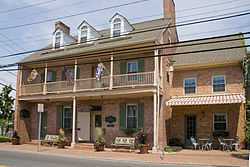
|
| 33 |
The Old Inn |
|
01980-03-25-0000March 25, 1980
(#80001840) |
Talbot and Mulberry Sts.
38°47′01″N 76°13′25″W / 38.783611°N 76.223611°W / 38.783611; -76.223611 (The Old Inn) |
St. Michaels |
|
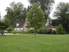
| 34 |
Old Wye Church |
|
01984-08-09-0000August 9, 1984
(#84001888) |
Queenstown-Easton Rd.
38°56′11″N 76°04′48″W / 38.936389°N 76.08°W / 38.936389; -76.08 (Old Wye Church) |
Wye Mills |
|
| 35 |
Orem's Delight |
Upload image |
01978-04-04-0000April 4, 1978
(#78001477) |
South of Bellevue off Ferry Neck Rd., on Benoni Point Rd.
38°41′10″N 76°12′11″W / 38.686111°N 76.203056°W / 38.686111; -76.203056 (Orem's Delight) |
Bellevue |
|
| 36 |
Otwell |
|
01982-03-15-0000March 15, 1982
(#82002819) |
Otwell Rd.
38°41′55″N 76°08′16″W / 38.698611°N 76.137778°W / 38.698611; -76.137778 (Otwell) |
Oxford |
|
| 37 |
Oxford Historic District |
|
02005-12-28-0000December 28, 2005
(#05001481) |
Roughly bounded by Tred Avon Rd., Town Creek, and Caroline Ave.
38°41′33″N 76°10′18″W / 38.6925°N 76.171667°W / 38.6925; -76.171667 (Oxford Historic District) |
Oxford |
|
| 38 |
Paw Paw Cove Site |
|
02009-12-23-0000December 23, 2009
(#09001150) |
Address Restricted
|
Tilghman |
|
| 39 |
PERSISTENCE (log canoe) |
Upload image |
01985-09-18-0000September 18, 1985
(#85002261) |
St. Michaels Marina
38°47′06″N 76°13′13″W / 38.785°N 76.220278°W / 38.785; -76.220278 (PERSISTENCE (log canoe)) |
St. Michaels |
|
| 40 |
RALPH T. WEBSTER |
Upload image |
01985-05-16-0000May 16, 1985
(#85001094) |
Gibsontown Rd.
38°42′46″N 76°19′53″W / 38.712778°N 76.331389°W / 38.712778; -76.331389 (RALPH T. WEBSTER) |
Tilghman |
|
| 41 |
REBECCA T. RUARK |
|
01985-05-16-0000May 16, 1985
(#85001095) |
Gibsontown Rd.
38°42′46″N 76°19′53″W / 38.712778°N 76.331389°W / 38.712778; -76.331389 (REBECCA T. RUARK) |
Tilghman |
|
| 42 |
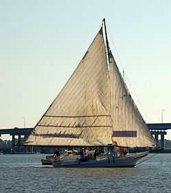
RELIANCE (Chesapeake Bay skipjack) |
Upload image |
01976-07-30-0000July 30, 1976
(#76001013) |
Knapps Narrows off Maryland Route 33
38°42′46″N 76°20′07″W / 38.712778°N 76.335278°W / 38.712778; -76.335278 (RELIANCE (Chesapeake Bay skipjack)) |
Tilghman |
|
| 43 |
Rock Clift |
Upload image |
01980-07-30-0000July 30, 1980
(#80001837) |
Southeast of Matthews off Maryland Route 328
38°48′12″N 75°56′37″W / 38.803333°N 75.943611°W / 38.803333; -75.943611 (Rock Clift) |
Matthews |
|
| 44 |
ROVER (log canoe) |
Upload image |
01985-09-18-0000September 18, 1985
(#85002262) |
St. Michaels Marina
38°47′06″N 76°13′13″W / 38.785°N 76.220278°W / 38.785; -76.220278 (ROVER (log canoe)) |
St. Michaels |
|
| 45 |
RUBY G. FORD |
Upload image |
01985-05-16-0000May 16, 1985
(#85001096) |
Gibsontown Rd.
38°42′46″N 76°19′53″W / 38.712778°N 76.331389°W / 38.712778; -76.331389 (RUBY G. FORD) |
Tilghman |
|
| 46 |
S.C. DOBSON (log canoe) |
Upload image |
01985-09-18-0000September 18, 1985
(#85002252) |
Peach Blossom Rd.
38°41′34″N 76°09′33″W / 38.692778°N 76.159167°W / 38.692778; -76.159167 (S.C. DOBSON (log canoe)) |
Oxford |
|
| 47 |
Saint Michaels Mill |
|
01982-07-15-0000July 15, 1982
(#82002820) |
100 Chew Ave.
38°46′56″N 76°13′13″W / 38.782222°N 76.220278°W / 38.782222; -76.220278 (Saint Michaels Mill) |
St. Michaels |
|
| 48 |
SANDY (log canoe) |
Upload image |
01985-09-18-0000September 18, 1985
(#85002253) |
Sherwood Rd.
38°45′40″N 76°19′09″W / 38.761111°N 76.319167°W / 38.761111; -76.319167 (SANDY (log canoe)) |
Sherwood |
|
| 49 |
Sharps Island Light |
|
01982-07-22-0000July 22, 1982
(#82002821) |
Southwest of Tilghman Island
38°38′19″N 76°22′05″W / 38.638611°N 76.368056°W / 38.638611; -76.368056 (Sharps Island Light) |
Tilghman Island |
|
| 50 |
Sherwood Manor |
Upload image |
01977-04-05-0000April 5, 1977
(#77000701) |
4 miles north of St. Michaels on Maryland Route 451
38°50′00″N 76°15′42″W / 38.833333°N 76.261667°W / 38.833333; -76.261667 (Sherwood Manor) |
St. Michaels |
|
| 51 |
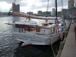
SIGSBEE |
|
01985-05-16-0000May 16, 1985
(#85001097) |
Knapps Narrows
38°43′09″N 76°20′02″W / 38.719167°N 76.333889°W / 38.719167; -76.333889 (SIGSBEE) |
Tilghman |
located in Baltimore, Maryland
|
| 52 |
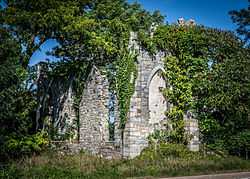
St. John's Chapel of St. Michael's Parish |
|
01973-03-30-0000March 30, 1973
(#73000938) |
3 miles west of Easton on Maryland Route 370
38°47′46″N 76°07′43″W / 38.796111°N 76.128611°W / 38.796111; -76.128611 (St. John's Chapel of St. Michael's Parish) |
Easton |
|
| 53 |
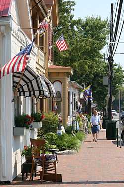
St. Michaels Historic District |
|
01986-09-11-0000September 11, 1986
(#86002427) |
Roughly bounded by North Ave., Mill St., the Miles River, Seymour, Baltimore and Eastern Railroad tracks, and Glory Ave.
38°47′04″N 76°13′24″W / 38.784444°N 76.223333°W / 38.784444; -76.223333 (St. Michaels Historic District) |
St. Michaels |
|
| 54 |
STANLEY NORMAN |
|
01985-05-16-0000May 16, 1985
(#85001086) |
Edgar Cove
38°45′58″N 76°15′37″W / 38.766111°N 76.260278°W / 38.766111; -76.260278 (STANLEY NORMAN) |
St. Michaels |
|
| 55 |
Tidewater Inn |
|
02007-11-02-0000November 2, 2007
(#07001118) |
101 E. Dover St.
38°46′28″N 76°04′29″W / 38.774444°N 76.074722°W / 38.774444; -76.074722 (Tidewater Inn) |
Easton |
|
| 56 |
Troth's Fortune |
|
01975-04-24-0000April 24, 1975
(#75000921) |
3.25 miles east of Easton on Maryland Route 331
38°45′49″N 75°59′41″W / 38.763611°N 75.994722°W / 38.763611; -75.994722 (Troth's Fortune) |
Easton |
|
| 57 |
Victorian Corn Cribs |
Upload image |
01976-01-11-0000January 11, 1976
(#76002289) |
6.8 miles east of St. Michaels off Maryland Route 33
38°47′10″N 76°08′11″W / 38.786111°N 76.136389°W / 38.786111; -76.136389 (Victorian Corn Cribs) |
St. Michaels |
|
| 58 |
VIRGINIA W |
Upload image |
01985-05-16-0000May 16, 1985
(#85001098) |
Knapps Narrows
38°43′09″N 76°20′02″W / 38.719167°N 76.333889°W / 38.719167; -76.333889 (VIRGINIA W) |
Tilghman |
|
| 59 |
The Wilderness |
Upload image |
01974-07-25-0000July 25, 1974
(#74000971) |
Southwest of Trappe on Island Neck Rd.
38°38′22″N 76°08′12″W / 38.639444°N 76.136667°W / 38.639444; -76.136667 (The Wilderness) |
Trappe |
|
| 60 |
Wye House |
|
01970-04-15-0000April 15, 1970
(#70000264) |
7 miles northwest of Easton on the Miles Neck River
38°51′02″N 76°10′14″W / 38.850556°N 76.170556°W / 38.850556; -76.170556 (Wye House) |
Easton |
|
| 61 |
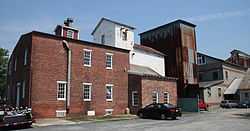
Wye Mill |
Upload image |
01985-04-09-0000April 9, 1985
(#85000717) |
14296 Old Wye Mills Road (Rt. 662)
Wye Mills, Maryland
38°56′29″N 76°04′53″W / 38.941389°N 76.081389°W / 38.941389; -76.081389 (Wye Mill) |
Wye Mills, Md |
|
| 62 |
Wye Town Farm House |
Upload image |
01982-12-16-0000December 16, 1982
(#82001600) |
Northwest of Easton on Bruff's Island Rd.
38°50′31″N 76°11′18″W / 38.841944°N 76.188333°W / 38.841944; -76.188333 (Wye Town Farm House) |
Easton |
|
.jpg)
.jpg)


.jpg)