National Register of Historic Places listings in Suffolk County, Massachusetts
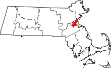
Location of Suffolk County in Massachusetts
This is a list of the National Register of Historic Places listings in Suffolk County, Massachusetts.
This is intended to be a complete list of the properties and districts on the National Register of Historic Places in Suffolk County, Massachusetts, United States. Latitude and longitude coordinates are provided for many National Register properties and districts; these locations may be seen together in a Google map.[1]
There are over 300 properties and districts listed on the National Register in the county, including 58 National Historic Landmarks. The city of Boston is the location of more than 275 of these properties and districts, including 57 National Historic Landmarks; they are listed separately. Properties and districts located in the county's other three municipalities are listed here.
- This National Park Service list is complete through NPS recent listings posted May 1, 2015.[2]
Current listings
For reasons of length, the Boston list has been split into northern and southern listings, divided by the Massachusetts Turnpike. Northern Boston has 144 of these listings, including 39 districts, 48 landmarks, and three National Historic Landmark Districts. Southern Boston, including locations in Boston Harbor, has 152 listings, including 43 districts, 12 landmarks, and one National Historic Landmark District. Two historic districts overlap into both northern and southern Boston: milestones that make up the 1767 Milestones are found in both areas, and the Olmsted Park System extends through much of the city.
Boston
| Area |
Image |
First Date listed |
Last Date listed |
Count |
|---|
| Northern |
 |
01966-10-15-0000October 15, 1966 |
02015-03-03-0000March 3, 2015 |
144 |
| Southern |
 |
01966-10-15-0000October 15, 1966 |
02014-10-08-0000October 8, 2014 |
152 |
Other municipalities
| [3] |
Name on the Register[4] |
Image |
Date listed[5] |
Location |
City or town |
Description |
|---|
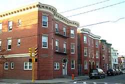
| 1 |
Bellingham Square Historic District |
|
01985-01-03-0000January 3, 1985
(#85000030) |
Roughly bounded by Broadway, Shawmut, Chestnut, and Shurtleff Sts.
42°23′37″N 71°02′02″W / 42.393494°N 71.033844°W / 42.393494; -71.033844 (Bellingham Square Historic District) |
Chelsea |
|
| 2 |
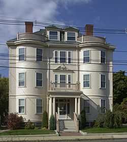
Bellingham-Cary House |
|
01974-09-06-0000September 6, 1974
(#74000908) |
34 Parker St.
42°23′52″N 71°02′19″W / 42.397778°N 71.038611°W / 42.397778; -71.038611 (Bellingham-Cary House) |
Chelsea |
|
| 3 |
Chelsea Garden Cemetery |
|
02001-02-09-0000February 9, 2001
(#01000089) |
70 Central Ave.
42°23′25″N 71°02′00″W / 42.390278°N 71.033333°W / 42.390278; -71.033333 (Chelsea Garden Cemetery) |
Chelsea |
|
| 4 |
Church of Christ |
|
01984-11-13-0000November 13, 1984
(#84000430) |
265 Beach St.
42°24′33″N 71°00′26″W / 42.409167°N 71.007222°W / 42.409167; -71.007222 (Church of Christ) |
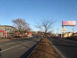
Revere |
|
| 5 |
Congregation Agudath Shalom |
|
01993-04-16-0000April 16, 1993
(#93000283) |
145 Walnut St.
42°23′34″N 71°02′17″W / 42.392778°N 71.038056°W / 42.392778; -71.038056 (Congregation Agudath Shalom) |
Chelsea |
|
| 6 |
Downtown Chelsea Residential Historic District |
|
01988-06-22-0000June 22, 1988
(#88000718) |
Roughly bounded by Shurtleff, Marginal, and Division Sts. and Bellingham Sq.
42°23′21″N 71°02′15″W / 42.389167°N 71.0375°W / 42.389167; -71.0375 (Downtown Chelsea Residential Historic District) |
Chelsea |
|
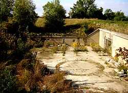
| 7 |
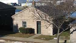
Fort Banks Mortar Battery |
|
02007-03-12-0000March 12, 2007
(#07000144) |
Kennedy Dr.
42°23′04″N 70°58′49″W / 42.384306°N 70.980278°W / 42.384306; -70.980278 (Fort Banks Mortar Battery) |
Winthrop |
|
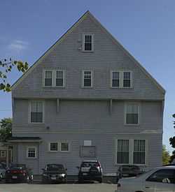
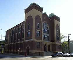
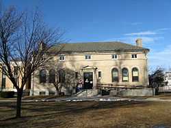
| 8 |
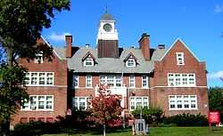
Highland School |
|
02014-03-18-0000March 18, 2014
(#14000063) |
36 Grovers Ave.
42°23′06″N 70°58′23″W / 42.385034°N 70.972947°W / 42.385034; -70.972947 (Highland School) |
Winthrop |
|
| 9 |
Immaculate Conception Rectory |
|
02002-02-11-0000February 11, 2002
(#01001559) |
108 Beach St.
42°24′25″N 71°00′42″W / 42.406944°N 71.011667°W / 42.406944; -71.011667 (Immaculate Conception Rectory) |
Revere |
|
| 10 |
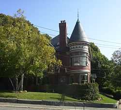
C. Henry Kimball House |
|
01982-04-15-0000April 15, 1982
(#82004464) |
295 Washington Ave.
42°23′58″N 71°02′06″W / 42.399444°N 71.035°W / 42.399444; -71.035 (C. Henry Kimball House) |
Chelsea |
|
| 11 |
Naval Hospital Boston Historic District |
|
01973-08-14-0000August 14, 1973
(#73000851) |
1 Broadway
42°23′13″N 71°02′44″W / 42.386864°N 71.045467°W / 42.386864; -71.045467 (Naval Hospital Boston Historic District) |
Chelsea |
|
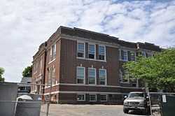
| 12 |
Edward B. Newton School |
|
01997-08-18-0000August 18, 1997
(#97000878) |
131 Pauline St.
42°22′33″N 70°59′13″W / 42.375833°N 70.986944°W / 42.375833; -70.986944 (Edward B. Newton School) |
Winthrop |
|
| 13 |
Revere Beach Parkway-Metropolitan Park System of Greater Boston |
|
02007-12-06-0000December 6, 2007
(#07001241) |
Revere Beach Pkwy
42°24′16″N 71°01′49″W / 42.404386°N 71.030361°W / 42.404386; -71.030361 (Revere Beach Parkway-Metropolitan Park System of Greater Boston) |
Chelsea |
Extends into Everett and Medford in Middlesex County
|
| 14 |
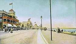
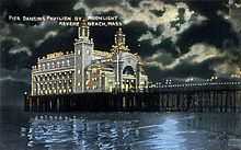
Revere Beach Reservation |
|
02003-05-27-0000May 27, 2003
(#03000642) |
Revere Beach Boulevard, Eliot Circle to Northern Circle
42°25′15″N 70°59′08″W / 42.420786°N 70.985683°W / 42.420786; -70.985683 (Revere Beach Reservation) |
Revere |
|
| 15 |
Revere Beach Reservation Historic District |
|
01998-07-15-0000July 15, 1998
(#98000871) |
Roughly bounded by Eliot Circle, Revere Beach Boulevard, Northern Circle, and the Atlantic Ocean
42°25′15″N 70°59′08″W / 42.420786°N 70.985683°W / 42.420786; -70.985683 (Revere Beach Reservation Historic District) |
Revere |
|
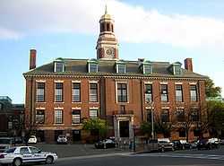
| 16 |
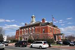
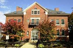
Revere City Hall and Police Station |
|
02012-03-07-0000March 7, 2012
(#12000070) |
281 Broadway & 23 Pleasant St.
42°24′28″N 71°00′47″W / 42.407892°N 71.013095°W / 42.407892; -71.013095 (Revere City Hall and Police Station) |
Revere |
|
| 17 |
Mary T. Ronan School |
|
01982-12-10-0000December 10, 1982
(#82000485) |
154 Bradstreet Ave.
42°23′46″N 70°59′14″W / 42.396111°N 70.987222°W / 42.396111; -70.987222 (Mary T. Ronan School) |
Revere |
|
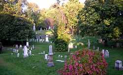
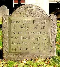
| 18 |
Rumney Marsh Burying Ground |
|
02004-02-11-0000February 11, 2004
(#04000025) |
Butler St. at Elm and Bixby Sts.
42°24′27″N 71°00′23″W / 42.4075°N 71.006389°W / 42.4075; -71.006389 (Rumney Marsh Burying Ground) |
Revere |
|
| 19 |
Winthrop Center/Metcalf Square Historic District |
|
02010-03-23-0000March 23, 2010
(#10000098) |
Roughly bounded by Lincoln, Winthrop Sts., Winthrop Cemetery, Buchanan, Fremont, Pauline, Hermon and Belcher Sts.
42°22′37″N 70°59′04″W / 42.377003°N 70.98445°W / 42.377003; -70.98445 (Winthrop Center/Metcalf Square Historic District) |
Winthrop |
|
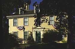
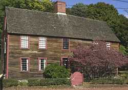
| 20 |
Deane Winthrop House |
|
01990-03-09-0000March 9, 1990
(#90000162) |
34 Shirley St.
42°22′57″N 70°58′41″W / 42.3825°N 70.978056°W / 42.3825; -70.978056 (Deane Winthrop House) |
Winthrop |
|
| 21 |
Winthrop Parkway, Metropolitan Parkway System of Greater Boston |
|
02004-01-21-0000January 21, 2004
(#03001471) |
Winthrop Parkway
42°23′29″N 70°58′55″W / 42.391389°N 70.981944°W / 42.391389; -70.981944 (Winthrop Parkway, Metropolitan Parkway System of Greater Boston) |
Revere |
|
| 22 |
Winthrop Shore Dr., Metropolitan Park System of Greater Boston |
|
02004-01-21-0000January 21, 2004
(#03001469) |
Winthrop Shore Dr.
42°22′11″N 70°58′05″W / 42.369722°N 70.968056°W / 42.369722; -70.968056 (Winthrop Shore Dr., Metropolitan Park System of Greater Boston) |
Winthrop |
|
References
- ↑ The latitude and longitude information provided in this table was derived originally from the National Register Information System, which has been found to be fairly accurate for about 99% of listings. For about 1% of NRIS original coordinates, experience has shown that one or both coordinates are typos or otherwise extremely far off; some corrections may have been made. A more subtle problem causes many locations to be off by up to 150 yards, depending on location in the country: most NRIS coordinates were derived from tracing out latitude and longitudes off of USGS topographical quadrant maps created under the North American Datum of 1927, which differs from the current, highly accurate WGS84 GPS system used by most on-line maps. Chicago is about right, but NRIS longitudes in Washington are higher by about 4.5 seconds, and are lower by about 2.0 seconds in Maine. Latitudes differ by about 1.0 second in Florida. Some locations in this table may have been corrected to current GPS standards.
- ↑ "National Register of Historic Places: Weekly List Actions". National Park Service, United States Department of the Interior. Retrieved on May 1, 2015.
- ↑ Numbers represent an ordering by significant words. Various colorings, defined here, differentiate National Historic Landmarks and historic districts from other NRHP buildings, structures, sites or objects.
- ↑ "National Register Information System". National Register of Historic Places. National Park Service. 2009-03-13.
- ↑ The eight-digit number below each date is the number assigned to each location in the National Register Information System database, which can be viewed by clicking the number.
|
|---|
| | Topics | | |
|---|
| | Lists by county | |
|---|
| | Lists by city | Barnstable County | |
|---|
| Bristol County | |
|---|
| Essex County | |
|---|
| Hampden County | |
|---|
| Middlesex County | |
|---|
| Norfolk County | |
|---|
| Suffolk County | |
|---|
| Worcester County | |
|---|
|
|---|
| | Other lists | |
|---|
|
-
 Category Category
-
 NRHP Portal NRHP Portal
- Massachusetts Portal
|
|