National Register of Historic Places listings in St. James Parish, Louisiana

Location of St. James Parish in Louisiana
This is a list of the National Register of Historic Places listings in St. James Parish, Louisiana.
This is intended to be a complete list of the properties and districts on the National Register of Historic Places in St. James Parish, Louisiana, United States. The locations of National Register properties and districts for which the latitude and longitude coordinates are included below, may be seen in a Google map.[1]
There are 22 properties and districts listed on the National Register in the parish, including 1 National Historic Landmark.
- This National Park Service list is complete through NPS recent listings posted May 1, 2015.[2]
Current listings
| [3] |
Name on the Register[4] |
Image |
Date listed[5] |
Location |
City or town |
Description |
|---|
| 1 |
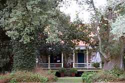
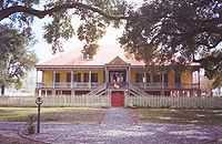
Bay Tree |
|
01991-11-21-0000November 21, 1991
(#91001738) |
3785 Louisiana Highway 18
30°00′11″N 90°46′51″W / 30.003056°N 90.780833°W / 30.003056; -90.780833 (Bay Tree) |
Vacherie |
|
| 2 |
Chauvin House |
|
02003-07-25-0000July 25, 2003
(#03000681) |
10138 Louisiana Highway 44
30°05′15″N 90°54′20″W / 30.0875°N 90.905556°W / 30.0875; -90.905556 (Chauvin House) |
Convent |
|
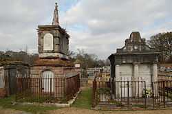
| 3 |
Colomb House |
Upload image |
01980-08-07-0000August 7, 1980
(#80004250) |
Northwest of Convent on River Rd.
30°04′02″N 90°51′24″W / 30.067222°N 90.856667°W / 30.067222; -90.856667 (Colomb House) |
Convent |
|
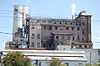
| 4 |
Colonial Sugars Historic District |
|
01994-10-11-0000October 11, 1994
(#94000858) |
1250 S. 5th Ave.
30°02′56″N 90°41′01″W / 30.048889°N 90.683611°W / 30.048889; -90.683611 (Colonial Sugars Historic District) |
Gramercy |
|
| 5 |
Desire Plantation House |
|
01986-05-15-0000May 15, 1986
(#86001054) |
Louisiana Highway 644
29°56′39″N 90°41′49″W / 29.944167°N 90.696944°W / 29.944167; -90.696944 (Desire Plantation House) |
Vacherie |
|
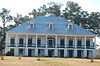
| 6 |
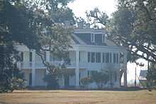
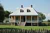
Felicity Plantation |
|
02010-03-08-0000March 8, 2010
(#10000062) |
3351 Louisiana Highway 18
30°00′25″N 90°46′22″W / 30.006933°N 90.772892°W / 30.006933; -90.772892 (Felicity Plantation) |
Vacherie |
|
| 7 |
Graugnard Farms Plantation House |
|
01992-05-14-0000May 14, 1992
(#92000510) |
5825 Louisiana Highway 18
29°59′28″N 90°50′07″W / 29.991111°N 90.835278°W / 29.991111; -90.835278 (Graugnard Farms Plantation House) |
St. James |
|
| 8 |
Lambert House |
|
02005-05-10-0000May 10, 2005
(#05000407) |
5669 Louisiana Highway 44
29°59′49″N 90°48′46″W / 29.996944°N 90.812778°W / 29.996944; -90.812778 (Lambert House) |
Convent |
|
| 9 |
Laura Plantation |
|
01993-02-03-0000February 3, 1993
(#92001842) |
2247 Louisiana Highway 18
30°00′21″N 90°43′26″W / 30.005833°N 90.723889°W / 30.005833; -90.723889 (Laura Plantation) |
Vacherie |
|
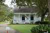
| 10 |
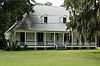
Little Texas |
|
01992-05-14-0000May 14, 1992
(#92000511) |
2834 Louisiana Highway 44
30°01′21″N 90°43′11″W / 30.0225°N 90.719722°W / 30.0225; -90.719722 (Little Texas) |
Paulina |
|
| 11 |
Longview |
Upload image |
01983-09-21-0000September 21, 1983
(#83000537) |
Louisiana Highway 44
30°02′13″N 90°41′52″W / 30.036944°N 90.697778°W / 30.036944; -90.697778 (Longview) |
Lutcher |
|
| 12 |
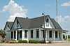
Lutcher & Moore Cypress Lumber Co., Ltd., Headquarters Building |
|
01994-05-13-0000May 13, 1994
(#94000411) |
2049 Railroad St.
30°02′25″N 90°41′52″W / 30.040278°N 90.697778°W / 30.040278; -90.697778 (Lutcher & Moore Cypress Lumber Co., Ltd., Headquarters Building) |
Lutcher |
|
| 13 |
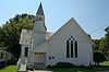
Lutcher United Methodist Church |
|
01992-02-13-0000February 13, 1992
(#92000042) |
2347 Texas St.
30°02′34″N 90°41′59″W / 30.042778°N 90.699722°W / 30.042778; -90.699722 (Lutcher United Methodist Church) |
Lutcher |
|
| 14 |
Manresa House of Retreats/Jefferson College |
|
01985-01-31-0000January 31, 1985
(#85000162) |
Louisiana Highway 44
29°59′34″N 90°49′15″W / 29.992778°N 90.820833°W / 29.992778; -90.820833 (Manresa House of Retreats/Jefferson College) |
Convent |
|
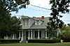
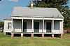
| 15 |
Mather House |
|
02001-05-30-0000May 30, 2001
(#01000569) |
5666 Louisiana Highway 44
29°59′45″N 90°48′48″W / 29.995833°N 90.813333°W / 29.995833; -90.813333 (Mather House) |
Convent |
|
| 16 |
Millet House |
|
01999-12-09-0000December 9, 1999
(#99001478) |
509 E. Jefferson Highway
30°02′40″N 90°41′08″W / 30.044444°N 90.685556°W / 30.044444; -90.685556 (Millet House) |
Gramercy |
|
| 17 |
Oak Alley Plantation |
|
01974-12-02-0000December 2, 1974
(#74002187) |
2.5 miles north of Vacherie
30°00′16″N 90°46′36″W / 30.004444°N 90.776667°W / 30.004444; -90.776667 (Oak Alley Plantation) |
Vacherie |
|
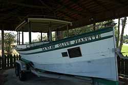
| 18 |
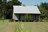
Olive Jeanette |
|
01991-10-03-0000October 3, 1991
(#91001421) |
Main St.
30°02′30″N 90°41′47″W / 30.041667°N 90.696389°W / 30.041667; -90.696389 (Olive Jeanette) |
Lutcher |
|
| 19 |
Our Lady of Peace Catholic Church |
|
02013-05-22-0000May 22, 2013
(#13000299) |
13281 LA 644
Coordinates missing |
Vacherie |
|
| 20 |
Judge Felix Poché Plantation House |
|
01980-12-03-0000December 3, 1980
(#80004251) |
River Rd.
30°00′44″N 90°49′37″W / 30.012222°N 90.826944°W / 30.012222; -90.826944 (Judge Felix Poché Plantation House) |
Convent |
|
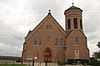
| 21 |
St. Joseph Plantation House |
|
02005-09-06-0000September 6, 2005
(#05000987) |
3535 Louisiana Highway 18
30°00′22″N 90°46′20″W / 30.006111°N 90.772222°W / 30.006111; -90.772222 (St. Joseph Plantation House) |
Vacherie |
|
| 22 |
St. Michael's Church Historic District |
|
01979-11-15-0000November 15, 1979
(#79003121) |
Louisiana Highway 44
30°00′40″N 90°49′31″W / 30.011111°N 90.825278°W / 30.011111; -90.825278 (St. Michael's Church Historic District) |
Convent |
|
See also
References
- ↑ The latitude and longitude information provided in this table was derived originally from the National Register Information System, which has been found to be fairly accurate for about 99% of listings. For about 1% of NRIS original coordinates, experience has shown that one or both coordinates are typos or otherwise extremely far off; some corrections may have been made. A more subtle problem causes many locations to be off by up to 150 yards, depending on location in the country: most NRIS coordinates were derived from tracing out latitude and longitudes off of USGS topographical quadrant maps created under the North American Datum of 1927, which differs from the current, highly accurate WGS84 GPS system used by most on-line maps. Chicago is about right, but NRIS longitudes in Washington are higher by about 4.5 seconds, and are lower by about 2.0 seconds in Maine. Latitudes differ by about 1.0 second in Florida. Some locations in this table may have been corrected to current GPS standards.
- ↑ "National Register of Historic Places: Weekly List Actions". National Park Service, United States Department of the Interior. Retrieved on May 1, 2015.
- ↑ Numbers represent an ordering by significant words. Various colorings, defined here, differentiate National Historic Landmarks and historic districts from other NRHP buildings, structures, sites or objects.
- ↑ "National Register Information System". National Register of Historic Places. National Park Service. 2009-03-13.
- ↑ The eight-digit number below each date is the number assigned to each location in the National Register Information System database, which can be viewed by clicking the number.
|
|---|
| | Topics | |
|---|
| | Lists by states | |
|---|
| | Lists by insular areas | |
|---|
| | Lists by associated states | |
|---|
| | Other areas | |
|---|
|
-
 Category Category
-
 Portal Portal
-
 WikiProject WikiProject
|
|

.jpg)